


Date: 16 March 2025
Location: Belize City, Belize
Credit: Copernicus Sentinel-2 image, processed by the CopernicusLAC Panama Centre
Description:
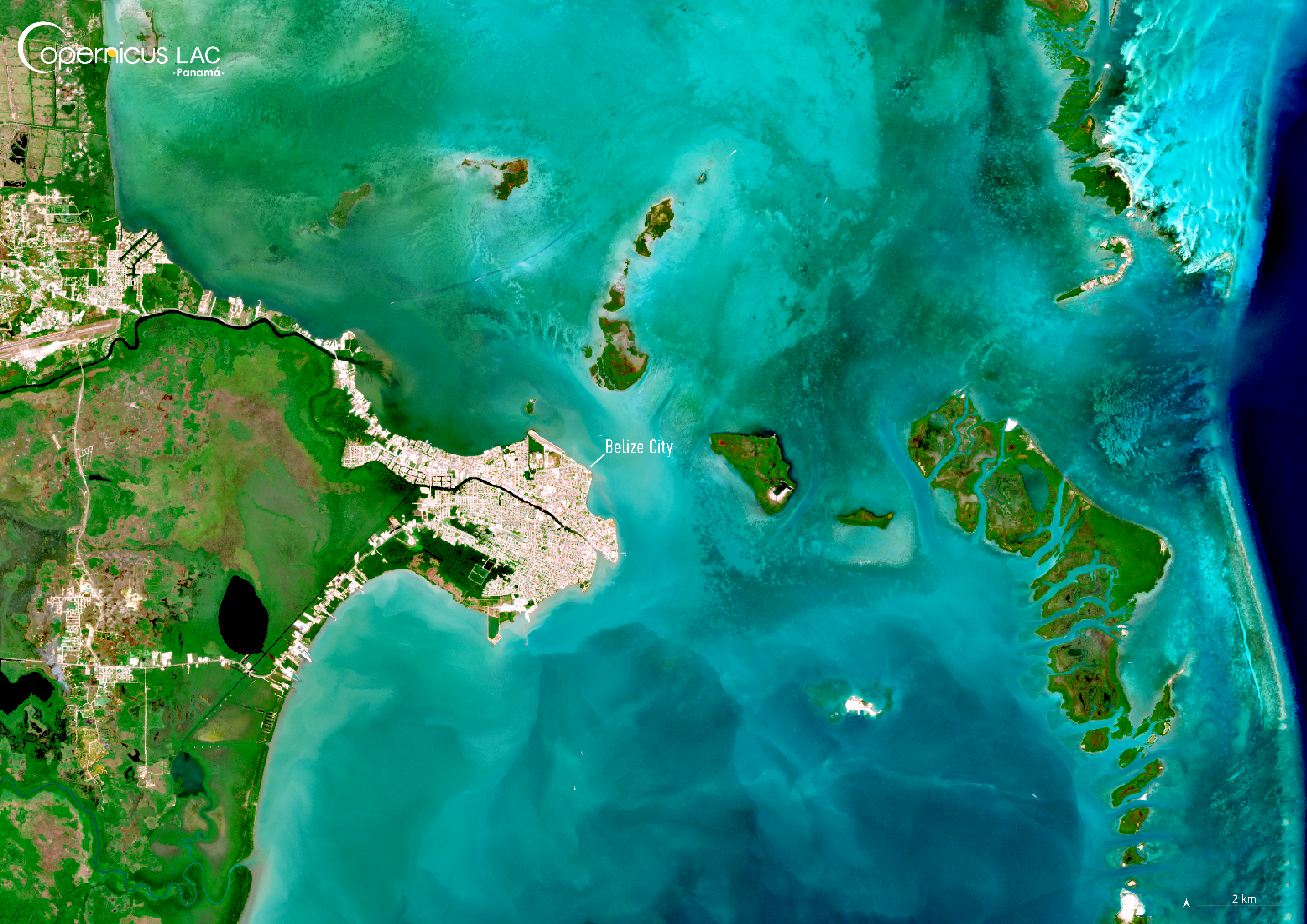
This Copernicus Sentinel-2 image, acquired on 16 March 2025, shows Belize City, Belize.
Belize is highly vulnerable to the consequences of climate change and the impacts of hazards such as hurricanes, storms, and the associated risks of flooding, wind damage, and storm surge, particularly in the Belize City area. The low-lying terrain of the country intensifies the effects of flooding and sea level rise.
For instance, between 2020 and 2024, Belize was impacted by several tropical systems, including Hurricane Lisa (2022) and Tropical Storm Sara (2024), which brought intense rainfall, flooding, and infrastructure damage across multiple districts. In parallel, recurring dry seasons have stressed water resources and threatened crop yields in the country’s interior.
In this context, the availability of timely, accurate, and location specific data is essential for risk reduction and disaster preparedness. To address this need, the CopernicusLAC Panama Centre is co-developing tailored Earth Observation services to support Belize and other countries in the LAC region respond more effectively to these hazards. These tools powered by the free and open data from Copernicus are meant to deliver key insights for national institutions, emergency responders, and development agencies, improving early warning systems, risk planning, and post-event recovery efforts.
To stay updated on the latest activities from our Centre, be sure to follow us on LinkedIn, Instagram, X, and subscribe to our newsletter.
Background Information
The Copernicus LAC Panama Centre’s activities take place within the overall context of the EU-LAC Digital Alliance, which is a strategic framework for promoting cooperation between the EU and the LAC region on digital and space issues under the EU Global Gateway umbrella. Within this context, the European Space Agency (ESA) is coordinating the Centre’s implementation on the basis of a Contribution Agreement with the Directorate-General for International Partnerships (DG INTPA) of the European Commission, and in close collaboration with Panama’s government, MIRE (Ministry of Foreign Affairs), Government Innovation Authority (AIG), and SENACYT (National Secretariat for Science, Technology and Innovation).
The CopernicusLAC Panama Centre will serve as a hub for innovation in the Latin America and Caribbean region, supporting national and local entities in leveraging Copernicus data and information to boost socio-economic benefits and resilience. In addition to providing engagement opportunities, the Centre is developing geospatial Disaster Risk Reduction (DRR) Earth Observation (EO) Services (addressing hydrometeorological hazards, wildfires, geological hazards, and hazard exposure) in close collaboration with local users and stakeholders, to whom they will be handed over to ensure that the unique needs of the region are addressed in the long term.
In addition, knowledge and skills transfer is a key element of the CopernicusLAC Panama Centre, which hosts a Digital Campus with access to training modules and educational resources for technical users and citizens alike. The Centre will also organise community-building events, policy dialogues and industry matchmaking, as well as hackathons and other EO data challenges to stimulate user adoption of Copernicus data and innovation. These events will also foster cross-collaboration among EO, disaster risk reduction (DRR) and other relevant ecosystems.
Finally, the Centre will support the development of a high-power computing and data storage cloud infrastructure for the LAC region. One of the final objectives of the Centre is to promote the development of communities of practice and to strengthen the knowledge and use of tools for DRR and other application areas in the public sector, academia, the private sector, and social organisations.