


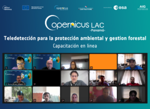
The CopernicusLAC Panama Centre successfully concluded its online training on Earth Observation (EO) for environmental protection and forest management on Friday, 26 September 2025. The five-day course, held from 22 to 26 September, brought together more than 200 participants from around 20 countries across Latin America and the Caribbean.
Led by experts Carmelo Alonso Jiménez and Alfredo Romo, the training provided a comprehensive programme covering from fundamental to advanced EO concepts, making extensive use of Sentinel satellite data and services of Copernicus. Each session combined theoretical explanations with practical exercises designed to consolidate learning and promote hands-on application.
Earth Observation applications for environmental protection
The first module introduced participants to the Sentinel missions relevant to environmental monitoring, the range of Copernicus services available to support environmental protection, and practical tools to access and visualise EO data using the Copernicus Data Space Ecosystem (CDSE). Building on this foundation, the module explored applications for biodiversity and ecosystem monitoring, with practical case studies such as drought detection using Sentinel-2 and change monitoring with Sentinel-1. The module concluded with an exercise on integrating EO data into decision-making processes through the assessment of air and water quality.
Earth Observation applications for forest management
The second module focused on the role of Earth Observation in advancing forest management. Participants explored relevant Copernicus datasets and ready-to-use products, alongside a practical exercise applying spectral indexes derived from Sentinel-2 and Sentinel-3 for forest monitoring. It was also highlighted the distinct advantages of Synthetic Aperture Radar (SAR) data for detecting forest change, illustrated through a case study on change detection techniques. Finally, it looked ahead to emerging trends and future developments in the use of EO for forest monitoring, providing participants with valuable insights into the field’s evolving landscape.
Participant Reflections
Feedback from participants emphasised the value of the course, noting the opportunities it provided to improve both academic and professional development. Copernicus was recognised as an exceptional resource for expanding knowledge and building key skills in the field. Participants especially valued the Sentinel datasets session, which provided a clear explanation of the different bands of satellite images.
Strengthening regional resilience
Through these initiatives the CopernicusLAC Panama Centre reaffirms its commitment to expanding technical knowledge and ensuring equitable access to EO technologies. By doing so, it supports the region’s capacity to respond effectively to the challenges posed by climate change and disasters.
The course materials and recordings are freely accessible on the Centre’s Digital Campus, requiring only user registration. The Digital Campus is integrated into the Centre’s broader capacity-building strategy, which includes in-person and online courses on topics related to sustainability and disasters risk reduction.
📝 Register to the digital campus here:
Background Information
The activities of the Centre fall within the overall context of the EU-LAC Digital Alliance, which is a strategic framework to promote cooperation between the European Union (EU) and the Latin America and Caribbean (LAC) region on digital and space issues under the umbrella of the EU Global Gateway strategy. In this context, the European Space Agency (ESA) coordinates the implementation of the Centre on the basis of a Contribution Agreement with the Directorate General for International Partnerships (DG INTPA) of the European Commission, and in close collaboration with the Government of Panama, the MIRE (Ministry of Foreign Affairs), the AIG (Government Innovation Authority), and the SENACYT (National Secretariat for Science, Technology and Innovation).