


On 28 October 2025, Hurricane Melissa made landfall in Jamaica as a catastrophic Category 5 storm, one of the most powerful ever recorded in the Atlantic basin. With wind speeds reaching 295 km/h and rainfall exceeding 1 meter in some regions, the island faces a critical post-disaster scenario.
In the context of disaster risk management, satellite technology plays a fundamental role in increasing climate resilience – particularly in Latin America and the Caribbean (LAC), where vulnerability to extreme weather events is high. The CopernicusLAC Panama Centre is developing satellite-based services to support disaster risk reduction and recovery activities through open-source tools and Earth Observation data from the Copernicus Sentinels’ in the LAC region.
In support of the Caribbean Institute for Meteorology and Hydrology (CIMH), two CopernicusLAC Panama services have delivered key information on the impacts of Melissa.
- The flood extent mapping service (developed by CIMA Foundation and WASDI Sarl) integrates SAR and optical imagery to detect and map water presence during extreme events.
- The economic value mapping (developed by Indra Espacio SLU) service estimates distributed economic value using 10-meter resolution maps.
The image below highlights the benefits of the combined output of these services:
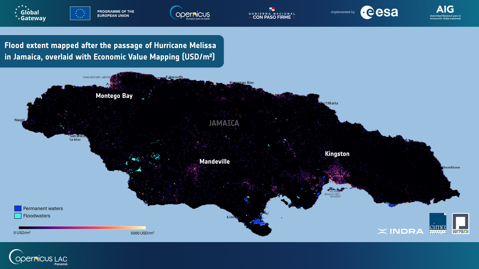
Flood extent mapped after the passage of Hurricane Melissa in Jamaica, overlaid with Economic Value Mapping (USD/m²). Credit: CopernicusLAC Panama Centre, 2025.
By overlaying these products over Jamaica it is possible to estimate the significant impacts caused by the passage of Hurricane Melissa:
- Around 3,000 hectares flooded in rural and industrial zones, particularly along the coast and Kingston port.
- Up to 123 million USD in potential economic value is affected by flooding.
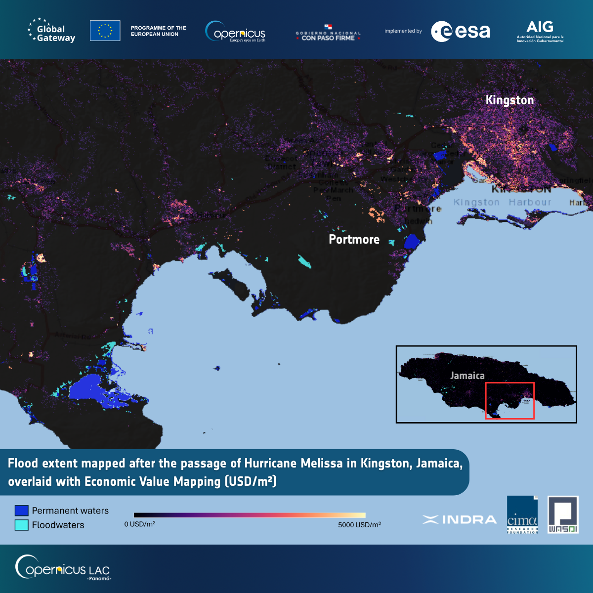
Flood extent mapped after the passage of Hurricane Melissa in Kingston, Jamaica, overlaid with Economic Value Mapping (USD/m²). Credit: CopernicusLAC Panama Centre, 2025.
David Farrell, Principal at the Caribbean Institute for Meteorology and Hydrology (CIMH) highlights the value of the information obtained:
“The CopernicusLAC Panama Centre flood-mapping service was an important and very useful tool for identifying and assessing the impacts of Hurricane Melissa as it approached, crossed and exited Jamaica. The tool allowed the CIMH to rapidly identify flooded areas even under cloud and rain. This real-time view strengthened our monitoring and coordination with disaster management teams, regional partners such as the Caribbean Disaster Emergency Management Agency among others and country level officials in Jamaica. In the post-event phase of this disaster, the information produced by the platform is expected to play a critical role in the identification of the most affected areas and inform relief actions across Jamaica. The CIMH takes this opportunity to thank the EU Commission and its agencies and programmes, including the Copernicus programme, for the significant support provided to the region during the passage of Hurricane Melissa.”
Through the development of these services, the CopernicusLAC Panama Centre aims to increase the use of Earth Observation data to strengthen disaster resilience across Latin America and the Caribbean. The Centre’s activities focus on both preparedness and post-disaster response, providing tools and services that are vital for effective planning, resource prioritization, and efficient recovery efforts. These services are co-developed with national and regional stakeholders to address the specific needs of users in the LAC region. This collaborative approach is key to empowering users across the region and ensuring that the solutions are both relevant and actionable.
Current developments include:
- 9 pre-operational services addressing floods, wildfires, landslides, and more.
- Over 20 regional institutions are engaged in co-development, demonstration, and validation of these services.
More information about the services’ capabilities can be found here.
Background information
The activities of the CopernicusLAC Panama Centre fall within the overall context of the EU-LAC Digital Alliance, which is a strategic framework to promote cooperation between the European Union (EU) and the Latin America and Caribbean (LAC) region on digital and space issues under the umbrella of the EU Global Gateway strategy. In this context, the European Space Agency (ESA) coordinates the implementation of the Centre on the basis of a Contribution Agreement with the Directorate General for International Partnerships (DG INTPA) of the European Commission, and in close collaboration with the Government of Panama, the MIRE (Ministry of Foreign Affairs) and the SENACYT (National Secretariat for Science, Technology and Innovation).