


Of the 20 countries most vulnerable to earthquakes, 11 are located in Latin America or the Caribbean. This heightened risk is largely due to the region’s geodynamics: Central America and the western coast of South America are affected by frequent earthquakes and volcanic activity due to the ongoing movement of tectonic plates in the region. Powerful earthquakes, including some of the strongest ever recorded, are primarily driven by subduction, whereby one plate is forced beneath another. This same tectonic process is also likely responsible for the formation of many of the region’s volcanoes.
The impacts of these seismic events go beyond immediate structural damage. Landslides, tsunamis, and disruption of essential services such as water, electricity, and telecommunications have compounded the challenges for affected communities following seismic events.
This article explores how Copernicus, the Earth Observation (EO) component of the European Union Space Programme, contributes to monitoring seismic hazards across the LAC region by providing near-real-time damage assessments and change detection. These tools improve early warning systems and inform emergency response operations, contributing to a more resilient approach to disaster risk reduction in the face of ongoing tectonic dynamics.
The Role of Copernicus EO satellite data and Services in monitoring seismic activity in the LAC Region
Copernicus provides a robust framework for monitoring hazards such as regional movements and volcanic activity, which can induce, among other phenomena, earthquakes, tsunamis, landslides, and lava flows. Copernicus delivers reliable, free, and open data with high frequency through its Sentinel satellites. This data allows scientists, emergency teams, and policymakers to better understand areas vulnerable to seismic activity, assess the impacts of ongoing events, and evaluate damage in the aftermath. Its integrated approach not only improves situational awareness but also supports long-term risk assessment and urban resilience planning.
At the heart of Copernicus’s ability to monitor ground deformation is the Sentinel-1 mission, which carries a Synthetic Aperture Radar (SAR) sensor capable of acquiring imagery in all weather conditions, day or night. A key technique employed, leveraging Copernicus Sentinel-1 data, is Interferometric Synthetic Aperture Radar (InSAR), which measures ground displacement with millimetre-level accuracy. InSAR enables the detection of land movements caused by tectonic shifts, volcanic unrest, and fault line activity. These measurements are essential in pre- and post-event assessments, allowing experts to model movements along faults. The frequent revisit time of Copernicus Sentinel-1 supports the development of dynamic hazard models.
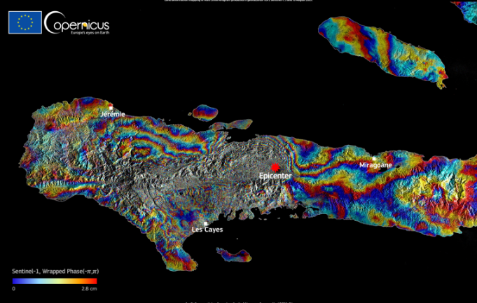
InSAR Interferogram of the 7.2 magnitude earthquake which struck Haiti on 14 August 2021, produced with radar data from Copernicus Sentinel-1. Credit: European Union, Copernicus Sentinel-1 imagery
While Sentinel-1 provides insights on surface deformation, the Copernicus Sentinel-2 mission complements it with optical imagery ideal for visual interpretation and damage assessment. The Sentinel-2 satellites’ multispectral sensors monitor landslides, provide information on thermal anomalies in volcanic areas, and map lava flow extent during volcanic eruptions. In the aftermath of tectonic or volcanic events, Sentinel-2 data supports assessments of damage to infrastructure and blocked roads or waterways, as well as estimates of the scale of affected populations. Sentinel-2 data also supports exposure mapping, helping determine which built environments and critical assets lie within high-risk areas. This information is crucial for emergency planners and civil protection agencies when prioritising response efforts and developing mitigation strategies.
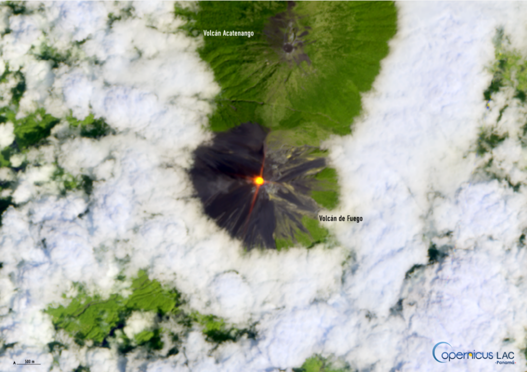
Copernicus Sentinel-2 image showing the thermal anomaly (infrared signature) detected at the summit of the Fuego Volcano in southern Guatemala on 9 March 2025. Credit: Copernicus Sentinel-2 image, processed by the CopernicusLAC Panama Centre
Finally, the Copernicus Emergency Management Service (CEMS) provides rapid, on-demand mapping products during and after disasters, including earthquakes, volcanic eruptions, or landslides. When activated, CEMS produces detailed maps of affected areas based on satellite data. These include delineation maps showing the extent of lava flows, grading maps which assess damage severity, and reference maps of key roads and infrastructure to support logistics and coordination on the ground. Beyond emergency response, CEMS complements local early warning systems and long-term recovery planning by supplying risk and exposure information. By leveraging satellite observations and geospatial data, CEMS ensures that stakeholders have the tools needed to act swiftly and effectively, reducing the human and economic toll of seismic events.
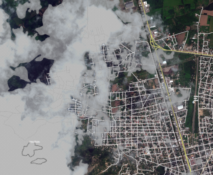
CEMS grading map showing the damage grade assessment of the area around the Salina Cruz Airport, Mexico, following a magnitude 8.2 earthquake on 7 September 2017. Credit: European Union, Copernicus Emergency Management Service
By combining precise information derived from the Copernicus Sentinel satellites and rapid-mapping products from CEMS, Copernicus equips authorities and researchers with the insights needed to mitigate risks, support emergency operations, and build long-term resilience in vulnerable areas in the LAC region.
The Role of the CopernicusLAC Panama Centre
This article outlined how Copernicus data is key to helping public authorities and local communities in the LAC region to better prepare for, respond to, and recover from seismic events and their consequences.
The CopernicusLAC Panama Centre serves as a hub for communities and individuals interested in harnessing free and open Copernicus data for disaster risk reduction and to address the challenges posed by climate change.
In particular, it is directly addressing seismic activity in the LAC region through its EO-based services. These will be delivered to local stakeholders for continued implementation after the demonstration phase. In addition to a hydrometeorological service and an exposure theme, the Centre will support the development of services within a geohazards theme. These services will leverage Copernicus Sentinel-1 radar data using SAR Interferometry (InSAR) techniques. There will be two services for precise terrain motion mapping, serving to detect and quantify surface displacements with high accuracy. Furthermore, there will be a SNAPPING IFG and Persistent Scatterer Interferometry (PSI) service and an Interferometric Stacking (IS) service. The services have applications in monitoring land subsidence, tectonic activity, volcanic deformation, and landslides, thereby supporting urban planning, disaster risk reduction, and infrastructure safety.
The Centre further hosts a Digital Campus, which provides free trainings and educational resources on EO data to all registered users. This includes lectures and materials focused on applications of Copernicus data for addressing earthquakes, volcanic eruptions, and other seismic activity. Register for the Digital Campus for free here.
About the CopernicusLAC Panama Centre
The activities of the Centre fall within the overall context of the EU-LAC Digital Alliance, which is a strategic framework to promote cooperation between the European Union (EU) and the Latin America and Caribbean (LAC) region on digital and space issues under the umbrella of the EU Global Gateway strategy. In this context, the European Space Agency (ESA) coordinates the implementation of the Centre on the basis of a Contribution Agreement with the Directorate General for International Partnerships (DG INTPA) of the European Commission, and in close collaboration with the Government of Panama, the MIRE (Ministry of Foreign Affairs) and the SENACYT (National Secretariat for Science, Technology and Innovation).
The CopernicusLAC Panama Centre will serve as a platform for innovation in the Latin America and Caribbean region, supporting national and local entities in leveraging Copernicus data and information to enhance socio-economic benefits and resilience. The Centre provides opportunities for engagement and is developing tailor-made EO Services (addressing hydrometeorological hazards, geological hazards and risk exposure services), which are developed in close collaboration with local users and stakeholders, to whom they will be delivered to ensure that the unique needs of the region are addressed in the long term.
In addition, knowledge and skills transfer is a key element of the CopernicusLAC Panama Centre, which hosts a Digital Campus with access to training modules and educational resources for technical users and citizens alike. The Centre will also organise community-building events, policy dialogues and industry matchmaking, as well as hackathons and other Earth observation (EO) data challenges to stimulate user adoption of Copernicus data and innovation. These events will also foster cross-collaboration of EO, Disaster Risk Reduction (DRR) and other relevant ecosystems.
Finally, the Centre will include the development of high-powered infrastructure and cloud computing for the LAC region. One of the ultimate objectives of the Centre is also to promote the development of communities of practice and strengthen capacities in the public sector, academia, the private sector and within social organisations in the knowledge and use of tools for DRR and other areas.