


In 2024, the population of the LAC region reached 663 million people, with projections indicating it will peak at approximately 730 million in 2053. As most urbanised regions in the world, the majority of the population is concentrated in cities and metropolises. As of 2024, around 81% of the LAC population lived in urban areas; by 2050, this number is expected to reach 89%. A significant driver of this urban growth is migration, particularly as a consequence of extreme weather events. Disasters such as hurricanes and prolonged droughts, the frequency of which have increased as a result of climate change, have prompted a vast number of rural residents to relocate to urban centres in search of better opportunities and safety.
The impacts of a growing rate of urbanisation range from more intense pollution to higher number of people exposed to disasters, since much of the population is concentrated in main urban settlements.
By exploring the role of Copernicus in monitoring urbanisation trends and population growth in the Latin American and Caribbean (LAC) region, this article introduces how Copernicus open data and services support LAC countries in increasing resilience to related challenges. As an initiative of the European Union’s Global Gateway strategy, the CopernicusLAC Panama Centre promotes the uptake of Copernicus data and serves as a hub for the development and use of EO products tailored to the specific needs of the LAC region.
The Role of Copernicus Data and Services for Urban Areas Monitoring
Monitoring population dynamics in urban environments
As urban areas in the LAC region expand at an unprecedented rate, understanding these growth patterns is crucial for sustainable development. In this regard, the Copernicus Emergency Management Service (CEMS) Global Human Settlement Layer (GHSL) is a tool which allows to monitor how cities grow and where people live. By integrating Sentinel satellites data and census data, this tool allows city planners to track changes, extract population density, and monitor urban sprawl. In addition, since 2016, the European Commission’s Joint Research Centre (JRC) has released periodic issues of The Human Planet Atlases, which have provided key insights based on GHSL data and addressed topics including urbanisation and disaster risk and exposure in urban areas.
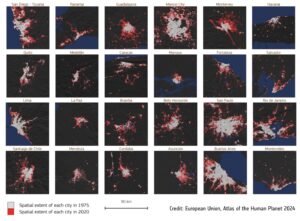
Visualising the growth of cities in the LAC region comparing Copernicus EMS Global Human Settlement Layer spatial extent data for 1975 and 2020. Credit: European Union, Atlas of the Human Planet 2024
Tracking urban green areas
Urban green areas, which play a key role in supporting biodiversity, reducing urban heat, and improving living conditions, are also monitored by leveraging Copernicus free and open data. In fact, Sentinel-2 satellite data enables the tracking of the health and size of these spaces, identifying changes over time. Furthermore, in coastal cities such as Lima, Sentinel-2 data also supports the monitoring of coastal erosion, linking urban growth to environmental impacts.
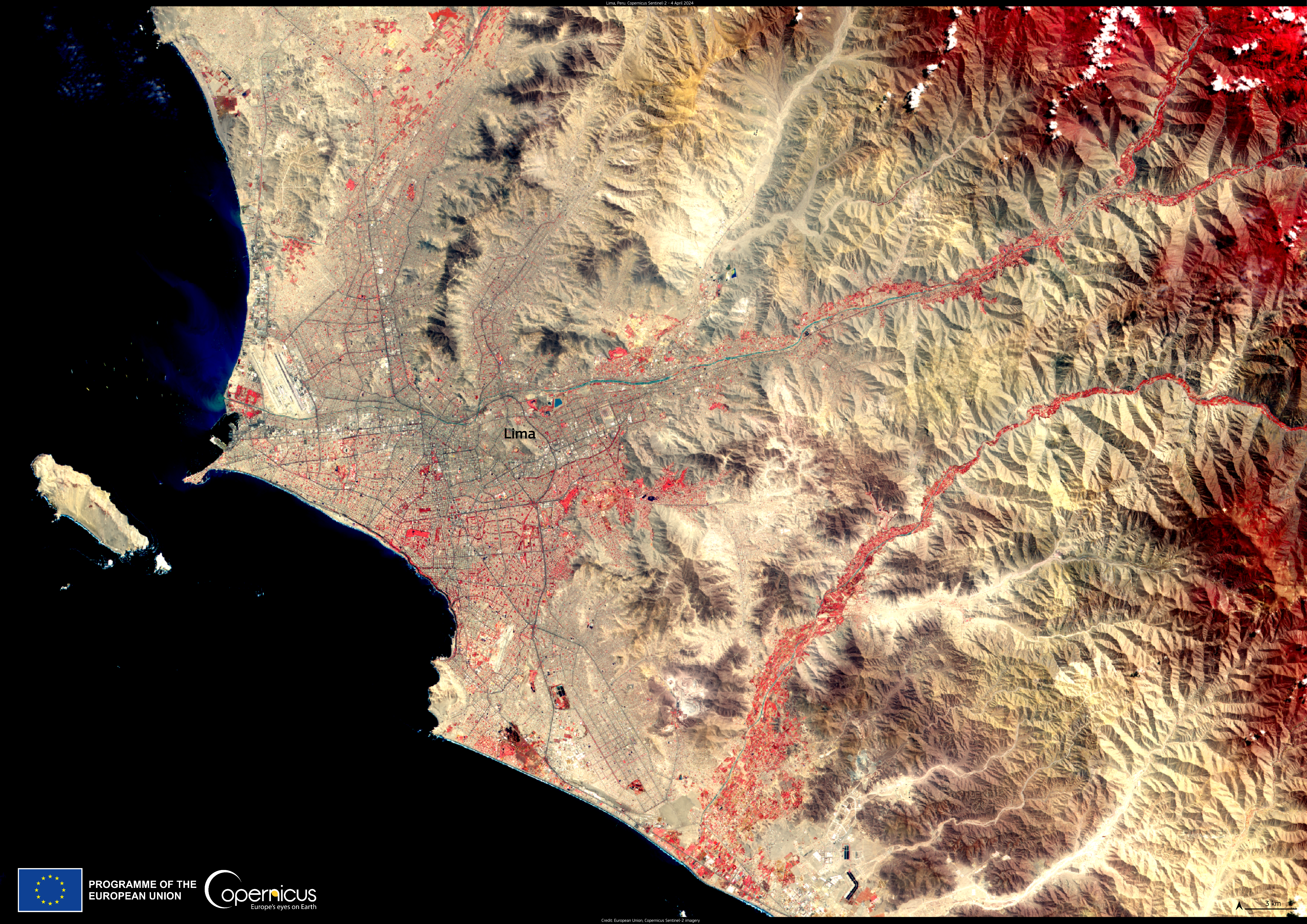
False-colour image of Lima, acquired by one of the Copernicus Sentinel-2 satellites on 4 April 2024. The use of false-colouring increases the visibility of urban green spaces such as parks, gardens, and tree-lined streets, making it easier to identify and monitor them within the city’s landscape. Credit: European Union, Copernicus Sentinel-2 imagery
Copernicus for monitoring water resources
Likewise, water resources are fundamental for urban populations, often sourced from areas outside densely populated centres. Copernicus Sentinel data enables monitoring of water reservoirs and drought conditions. For example, in Chile, Copernicus data has been used to track drought impacts on water supplies, supporting sustainable water management and urban planning.
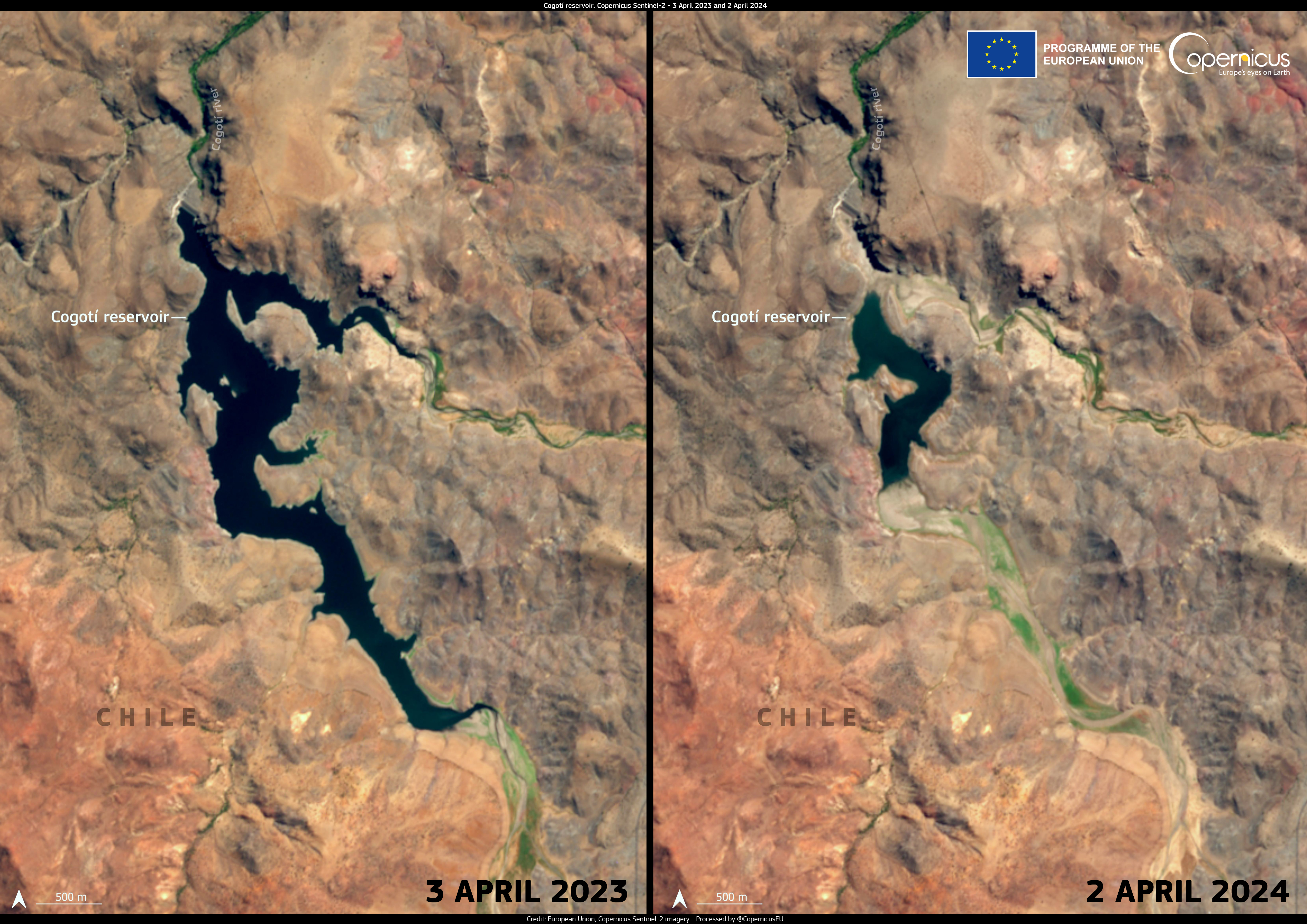
Copernicus Sentinel-2 images from April 2023 and April 2024 show the difference in the amount of water in the Cogotí Reservoir, North of Santiago, Chile.
Monitoring ground subsidence in urban areas
Finally, another important topic closely related to rapid urbanisation and urban sprawl is ground subsidence (sinking ground), which can be caused by seismic activity, volcanic eruptions, tectonic shifts, landslides, and human activities such as mining and construction as well as excessive groundwater withdrawal. This type of hazard poses significant risk to urban infrastructure. To this end, Copernicus Sentinel-1 satellite data allows for the detection of small land movements, informing disaster risk reduction strategies and supporting local authorities and urban planners in mitigating risks and ensuring public safety.
The Role Played by the CopernicusLAC Panama Centre
As the trend towards population growth and increased urbanisation in the LAC region continues, Copernicus data will play an even more significant role in helping public authorities and local communities to prepare for and respond to the resulting challenges.
In this context, the CopernicusLAC Panama Centre serves as a focal point for communities and individuals interested in leveraging free and open Copernicus data in relation to a variety of hazards and climate change-induced challenges.
One of the main activities of the Centre is the development of Earth Observation (EO) Services within three thematic areas: hydrometeorological hazards, geological hazards, and exposure.
Within the hydrometeorological theme, an urban flood mapping service is under development to improve flood detection in urban areas by providing event-based flood delineation maps in urban or scarcely vegetated areas. The service will be tested in the “flood historical record in urban areas” use case, taking place in Bolivia.
The Centre will further support the development of services within a geological hazards thematic area. These services will provide information on landslides and other hazards liked to the movement of the ground, such as seismic activity and subsidence. To test their applicability in urban areas, the services will be demonstrated in Panama in the “precise terrain motion mapping” use case by leveraging Copernicus Sentinel-1 measurements for ground motion detection.
The exposure thematic area focuses on quantifying the value of assets exposed to the abovementioned hazard types. One of these products is the urban characterisation service, which uses EO and other data to provide high-resolution dynamic information on the features of urban land, including building heights, population density, and built-up area. The service will be demonstrated in the “urban characterisation for exposure mapping” use case.
All of the Services will be delivered to local stakeholders for continued implementation after the pilot demonstration phase of the project.
In addition to developing ad-hoc Services for the region, the CopernicusLAC Panama Centre hosts policy dialogues, private sector support, workshops and community events, while providing trainings and educational resources on EO data, including applications related to urban areas and population growth. Furthermore, in October 2024, the Centre hosted its first hackathon, which featured three key challenges which participants addressed by leveraging Copernicus data. Under one of these challenges, dedicated to “Predicting and preparing for future disasters”, the team which won first place for their project “Monitoring Informal Urban Growth” proposed the application of Copernicus data for the monitoring and analysis of informal urban expansion in Peruvian cities. Through these events and opportunities, the Centre acts as a central hub for community engagement, as well as the exchange of knowledge and skills on these topics.
Finally, in parallel to the activities mentioned above, the Centre’s activities will also include technical assistance and the development of tools for the scoping, design, and installation of a Copernicus Data Centre in Panama, which will ensure privileged access to Copernicus data for users in the region.
Background Information
The Copernicus LAC Panama Centre’s activities take place within the overall context of the EU-LAC Digital Alliance, which is a strategic framework for promoting cooperation between the EU and the LAC region on digital and space issues under the EU Global Gateway umbrella. Within this context, the European Space Agency (ESA) is coordinating the Centre’s implementation on the basis of a Contribution Agreement with the Directorate-General for International Partnerships (DG INTPA) of the European Commission, and in close collaboration with Panama’s government, MIRE (Ministry of Foreign Affairs), Government Innovation Authority (AIG), and SENACYT (National Secretariat for Science, Technology and Innovation).