


Date: 9 March 2025
Location: Fuego Volcano, Guatemala
Credit: Copernicus Sentinel-2 image, processed by the CopernicusLAC Panama Centre
Description:
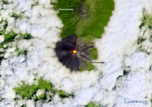
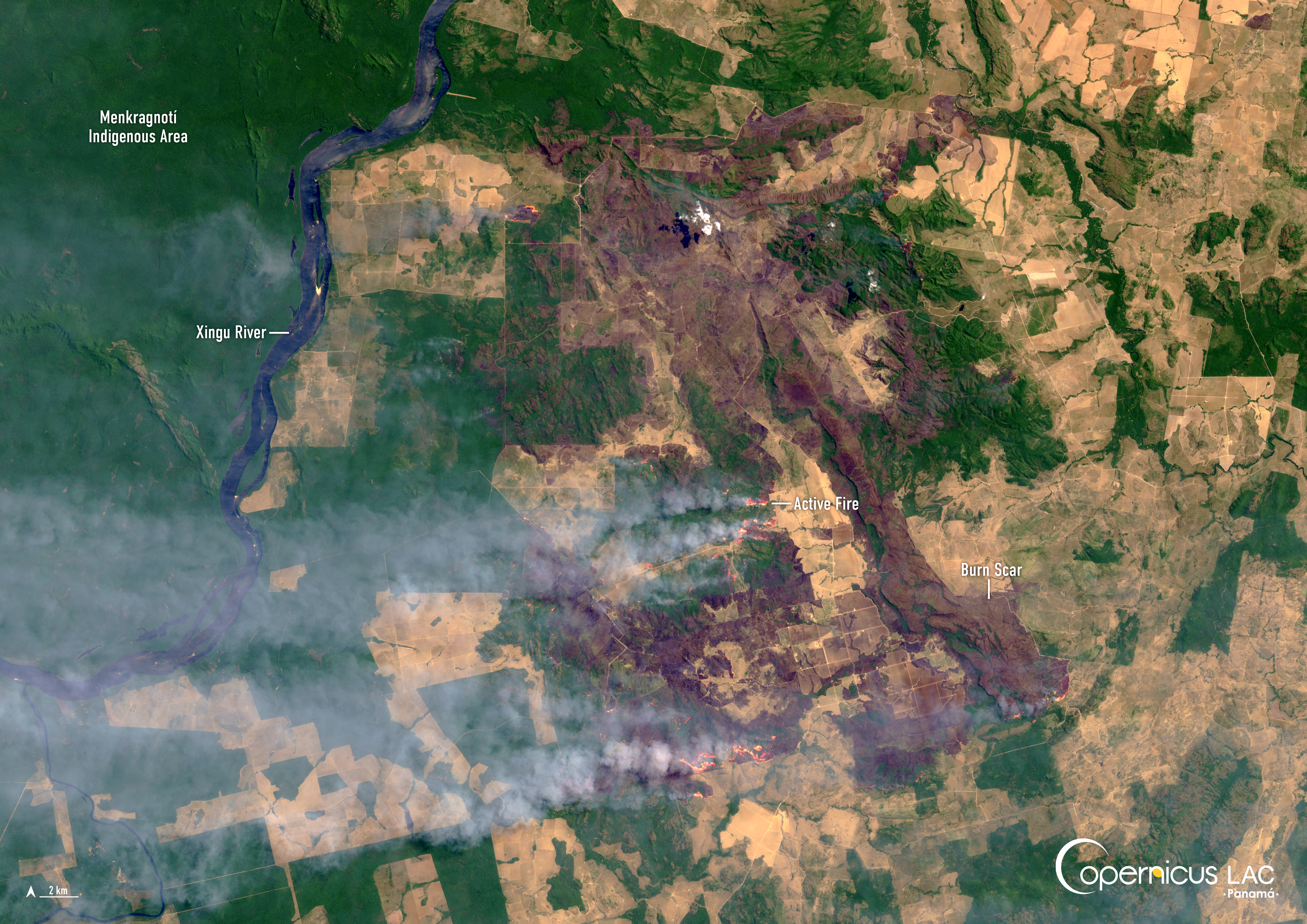
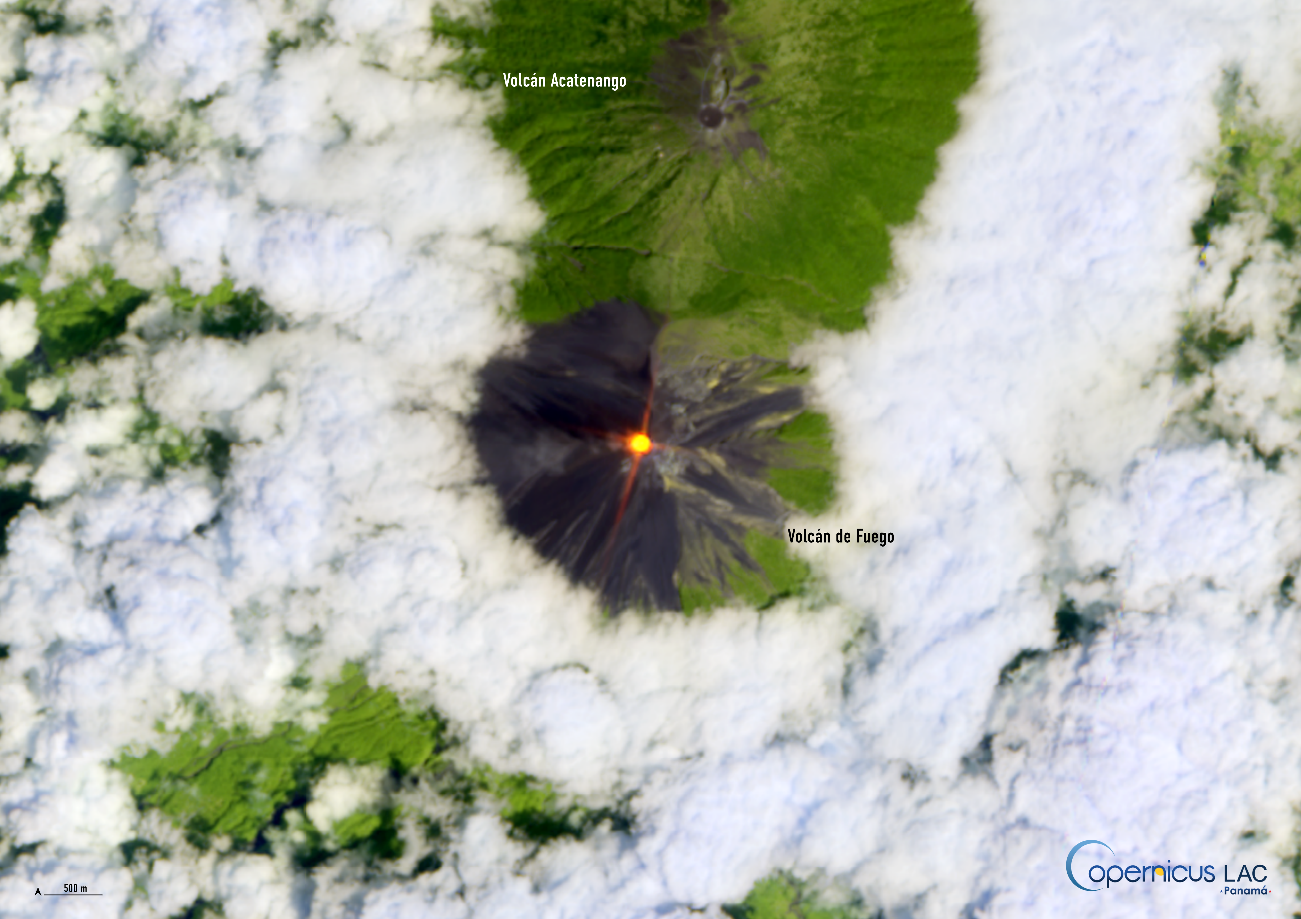
On 9 March 2025, the Fuego Volcano in southern Guatemala began erupting, leading to an ash column which reached up to 6,000 metres above sea level and travelled a distance of up to 120 km from the crater. Guatemalan authorities reported that over 1,000 individuals in the vicinity were safely evacuated.
The Fuego Volcano is one of the most active volcanoes in Central America. It is visible in this Copernicus Sentinel-2 image acquired on 9 March 2025, in which the thermal anomaly (infrared signature) detected at the summit of the Fuego Volcano is shown in red.
To support authorities and researchers in the LAC region in monitoring seismic activity, including the one related to volcanic eruptions, the CopernicusLAC Panama Centre is developing tailored Earth Observation services. These will support users in leveraging free and open Copernicus data to prepare and respond to these events, helping to keep affected communities safer.
Furthermore, the Centre hosts online and in-person training courses on the applications of Copernicus data for disaster risk reduction. The materials from these courses, some of which are related to volcano monitoring, are available for free for all registered users of our Digital Campus.
To stay up to date on future training courses and opportunities from the CopernicusLAC Panama Centre, follow us on LinkedIn, Instagram, and X, and subscribe to our newsletter!
Background Information
The Copernicus LAC Panama Centre’s activities take place within the overall context of the EU-LAC Digital Alliance, which is a strategic framework for promoting cooperation between the EU and the LAC region on digital and space issues under the EU Global Gateway umbrella. Within this context, the European Space Agency (ESA) is coordinating the Centre’s implementation on the basis of a Contribution Agreement with the Directorate-General for International Partnerships (DG INTPA) of the European Commission, and in close collaboration with Panama’s government, MIRE (Ministry of Foreign Affairs), Government Innovation Authority (AIG), and SENACYT (National Secretariat for Science, Technology and Innovation).
The CopernicusLAC Panama Centre will serve as a hub for innovation in the Latin America and Caribbean region, supporting national and local entities in leveraging Copernicus data and information to boost socio-economic benefits and resilience. In addition to providing engagement opportunities, the Centre is developing geospatial Disaster Risk Reduction (DRR) Pilot Services (addressing hydrometeorological hazards, geological hazards, and hazard exposure) in close collaboration with local users and stakeholders, to whom they will be handed over to ensure that the unique needs of the region are addressed in the long term.
In addition, knowledge and skills transfer is a key element of the CopernicusLAC Panama Centre, which hosts a Digital Campus with access to training modules and educational resources for technical users and citizens alike. The Centre will also organise community-building events, policy dialogues and industry matchmaking, as well as hackathons and other Earth Observation (EO) data challenges to stimulate user adoption of Copernicus data and innovation. These events will also foster cross-collaboration among EO, disaster risk reduction (DRR) and other relevant ecosystems.
Finally, the Centre will support the development of a high-power computing and data storage cloud infrastructure for the LAC region. One of the final objectives of the Centre is to promote the development of communities of practice and to strengthen the knowledge and use of tools for DRR and other application areas in the public sector, academia, the private sector, and social organisations.