


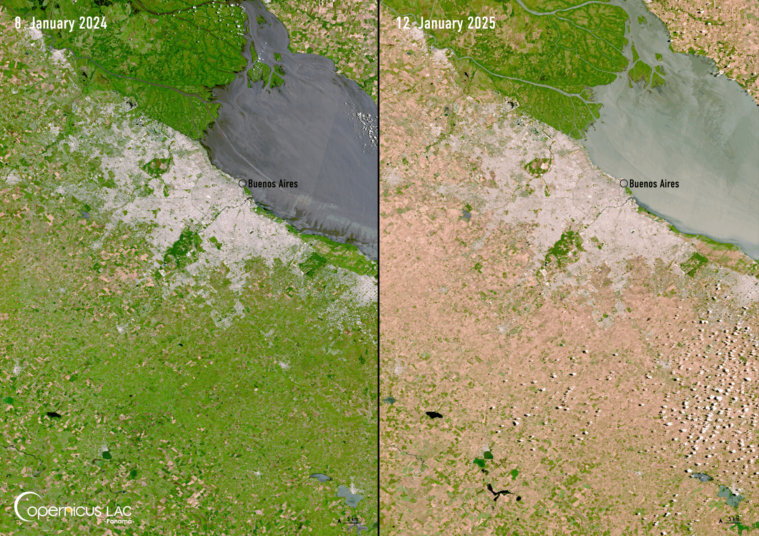
Date: 8 January 2024 and 12 January 2025
Location: Buenos Aires, Argentina
Credit: Copernicus Sentinel-2 image, processed by the CopernicusLAC Panama Centre
Description:
In early 2025, a severe drought affected parts of Argentina, particularly in the north and east of the country. The drought, linked to La Niña, left corn and soybean crops damaged, impacting yield forecasts of Argentina’s key grain exports.
The impact of the drought is visible when comparing images of Buenos Aires and the surrounding area, acquired on 8 January 2024 and 12 January 2025 by the Copernicus Sentinel-2 satellites. In the more recent image, the area appears drier and less vegetated, indicating clear signs of drought-induced stress.
To support Argentina and other Latin American and Caribbean (LAC) countries in addressing the consequences of drought, the CopernicusLAC Panama Centre is co-developing an Earth observation (EO)-based service for Drought Indices Mapping. The service will calculate and combine indices relevant for drought monitoring, including anomalies related to precipitation, soil moisture, and vegetation. These indices are derived from EO data combined with climatic time series analyses, and will provide insights on drought conditions to local stakeholders.
To stay updated on the latest activities from our Centre, be sure to follow us on LinkedIn, Instagram, X, and subscribe to our newsletter.
Background Information
The Copernicus LAC Panama Centre’s activities take place within the overall context of the EU-LAC Digital Alliance, which is a strategic framework for promoting cooperation between the EU and the LAC region on digital and space issues under the EU Global Gateway umbrella. Within this context, the European Space Agency (ESA) is coordinating the Centre’s implementation on the basis of a Contribution Agreement with the Directorate-General for International Partnerships (DG INTPA) of the European Commission, and in close collaboration with Panama’s government, MIRE (Ministry of Foreign Affairs), Government Innovation Authority (AIG), and SENACYT (National Secretariat for Science, Technology and Innovation).
The CopernicusLAC Panama Centre will serve as a hub for innovation in the Latin America and Caribbean region, supporting national and local entities in leveraging Copernicus data and information to boost socio-economic benefits and resilience. In addition to providing engagement opportunities, the Centre is developing geospatial Disaster Risk Reduction (DRR) Pilot Services (addressing hydrometeorological hazards, geological hazards, and hazard exposure) in close collaboration with local users and stakeholders, to whom they will be handed over to ensure that the unique needs of the region are addressed in the long term.
In addition, knowledge and skills transfer is a key element of the CopernicusLAC Panama Centre, which hosts a Digital Campus with access to training modules and educational resources for technical users and citizens alike. The Centre will also organise community-building events, policy dialogues and industry matchmaking, as well as hackathons and other Earth Observation (EO) data challenges to stimulate user adoption of Copernicus data and innovation. These events will also foster cross-collaboration among EO, disaster risk reduction (DRR) and other relevant ecosystems.
Finally, the Centre will support the development of a high-power computing and data storage cloud infrastructure for the LAC region. One of the final objectives of the Centre is to promote the development of communities of practice and to strengthen the knowledge and use of tools for DRR and other application areas in the public sector, academia, the private sector, and social organisations.