


Date: 12 February 2022
Location: Port of Spain, Trinidad and Tobago
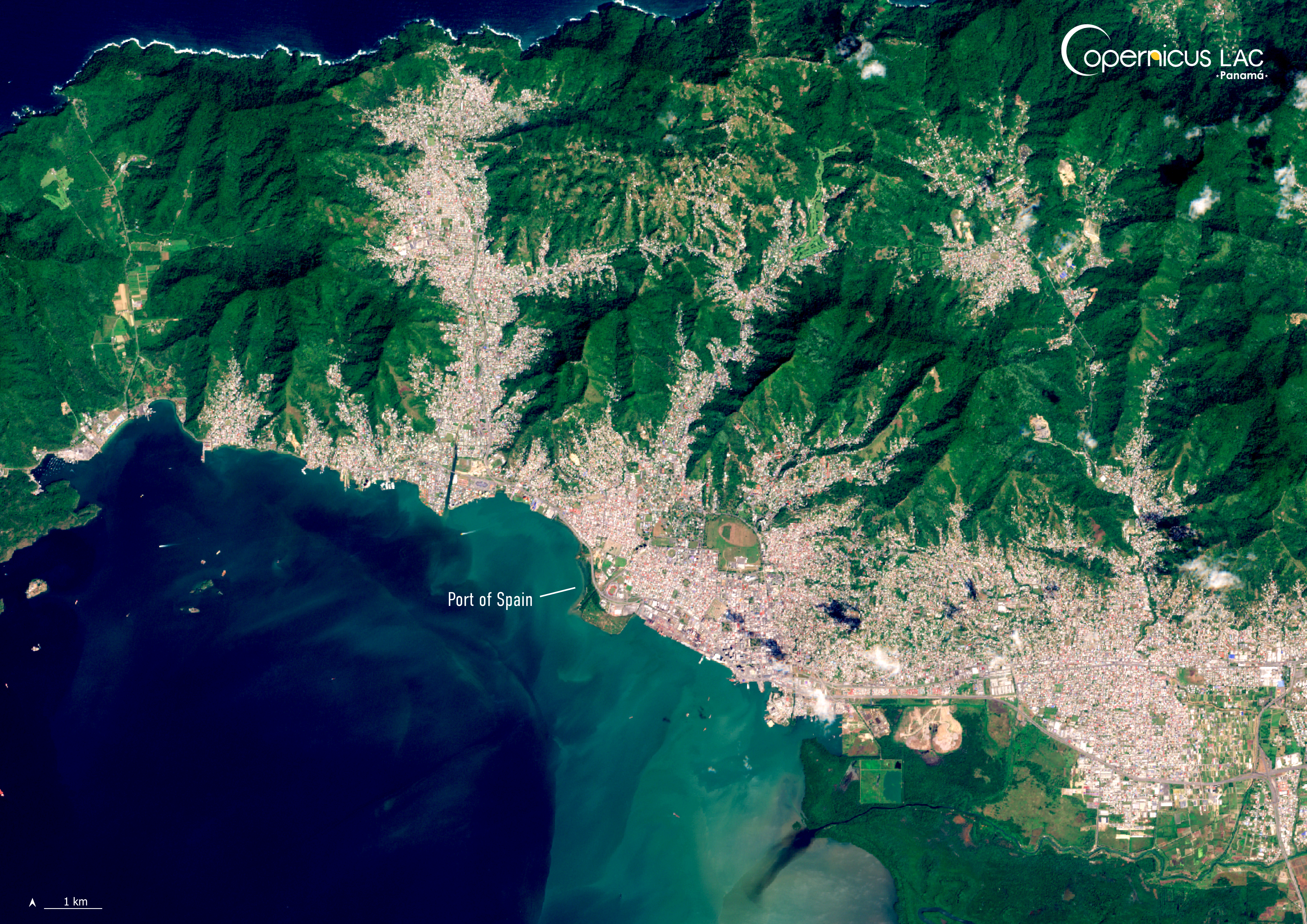
Credit: Copernicus Sentinel-2 image, processed by the CopernicusLAC Panama Centre
Description:
This Copernicus Sentinel-2 image, acquired on 12 February 2022, shows Port of Spain — capital of Trinidad and Tobago, the archipelago country located at southern extremity of the Caribbean islands, just off the coast of Venezuela.
Trinidad and Tobago is known for its rich biodiversity, but the archipelago is also particularly vulnerable to the cascading impacts of climate change. The country’s terrain consists of a mix of low-lying areas and mountainous regions which are susceptible to landslides and vulnerable to coastal flooding. Additionally, the islands are located on the border between the Caribbean and South American plates, making the area seismically active.
In recent years, the islands climate patterns have become more irregular. For instance, the November 2022 floods, triggered by persistent heavy rains, led to widespread damage to homes, infrastructure, and agriculture across both islands, affecting approximately 100,000 people. In August 2023, instead, an unprecedented heat wave affected the country during a period typically characterised by wet season conditions.
To complement regional capacities in disaster risk management, the CopernicusLAC Panama Centre is co-developing a set of Earth Observation services powered by Copernicus free and open data and tailored to the local needs. The products derived from these services include flood extent mapping, drought conditions monitoring and exposure analyses in relation to disasters events.
The Centre also promotes capacity building by providing practical training and learning resources through its Copernicus LAC Panama Centre Digital Campus. Registered users can access various courses, enabling both beginners and experienced professionals to improve their ability to use Copernicus data for disaster‑risk reduction.
To stay updated on the latest activities from our Centre, be sure to follow us on LinkedIn, Instagram, X, and subscribe to our newsletter.
Background Information
The Copernicus LAC Panama Centre’s activities take place within the overall context of the EU-LAC Digital Alliance, which is a strategic framework for promoting cooperation between the EU and the LAC region on digital and space issues under the EU Global Gateway umbrella. Within this context, the European Space Agency (ESA) is coordinating the Centre’s implementation on the basis of a Contribution Agreement with the Directorate-General for International Partnerships (DG INTPA) of the European Commission, and in close collaboration with Panama’s government, MIRE (Ministry of Foreign Affairs), Government Innovation Authority (AIG), and SENACYT (National Secretariat for Science, Technology and Innovation).
The CopernicusLAC Panama Centre will serve as a hub for innovation in the Latin America and Caribbean region, supporting national and local entities in leveraging Copernicus data and information to boost socio-economic benefits and resilience. In addition to providing engagement opportunities, the Centre is developing geospatial Disaster Risk Reduction (DRR) Earth Observation (EO) Services (addressing hydrometeorological hazards, wildfires, geological hazards, and hazard exposure) in close collaboration with local users and stakeholders, to whom they will be handed over to ensure that the unique needs of the region are addressed in the long term.
In addition, knowledge and skills transfer is a key element of the CopernicusLAC Panama Centre, which hosts a Digital Campus with access to training modules and educational resources for technical users and citizens alike. The Centre will also organise community-building events, policy dialogues and industry matchmaking, as well as hackathons and other EO data challenges to stimulate user adoption of Copernicus data and innovation. These events will also foster cross-collaboration among EO, disaster risk reduction (DRR) and other relevant ecosystems.
Finally, the Centre will support the development of a high-power computing and data storage cloud infrastructure for the LAC region. One of the final objectives of the Centre is to promote the development of communities of practice and to strengthen the knowledge and use of tools for DRR and other application areas in the public sector, academia, the private sector, and social organisations.