


Every year, disasters cost lives, damage ecosystems and disrupt economies around the world. In 2024 alone, the Emergency Events Database (EM-DAT) recorded 393 natural hazard-related disasters, resulting in 16,753 fatalities, affecting 167.2 million people, and causing more than $240 billion in economic losses. As extreme events become more frequent and intense because of climate change, investing in preparedness and resilience has never been more urgent.
Today, 13 October, on the International Day for Disaster Risk Reduction under the theme “Fund Resilience, Not Disasters”, the world is called to make a decisive shift, from reactive responses to proactive investments which prepare communities before crises occur. This shift requires not only financial commitment but also the strategic use of science and data to anticipate risks, reduce vulnerabilities and increase preparedness.
In this context, Earth Observation (EO) emerges as a key tool for reducing disaster risk. EO data is not only key for monitoring disasters as they occur, but also supports early warning capabilities, helping societies anticipate risks, reduce vulnerabilities, and plan effective mitigation strategies.
Copernicus: Supporting Global Preparedness and Recovery from Space
At the heart of this effort is Copernicus, the Earth Observation component of the European Union’s Space Programme. Copernicus delivers free, open and reliable satellite data through its Sentinel missions, supporting scientists, policymakers and emergency teams around the world.
These data allow users to better understand which areas are most exposed to hazards, to monitor events as they occur, and to evaluate damage in the aftermath. For instance, the radar instruments of Copernicus Sentinel-1 make it possible to identify flooded areas or monitor ground movements with millimetre precision. These measurements are essential in pre- and post-event assessments.
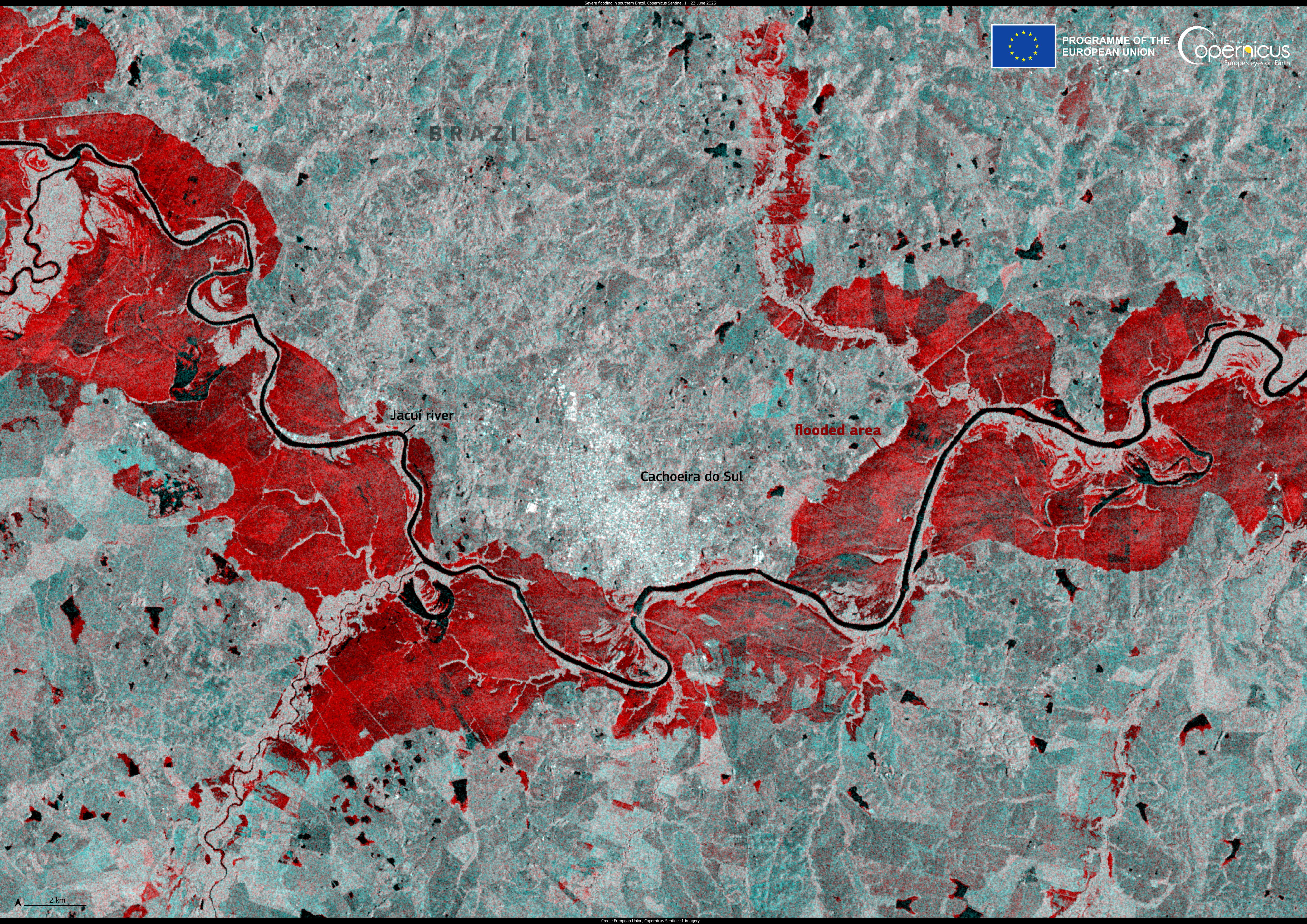
False-color image showing flooded areas (in red) along the Jacuí River in southern Brazil on 23 June 2025. Credit: European Union, Copernicus Sentinel-1 imagery
The Sentinel-2 mission complements the Sentinel-1 data with high-resolution optical imagery which supports visual interpretation and damage assessment. Its multispectral sensors can reveal for instance the extent of landslides, fires, and changes in vegetation, helping authorities to evaluate damages in the affected areas and plan recovery operations efficiently.
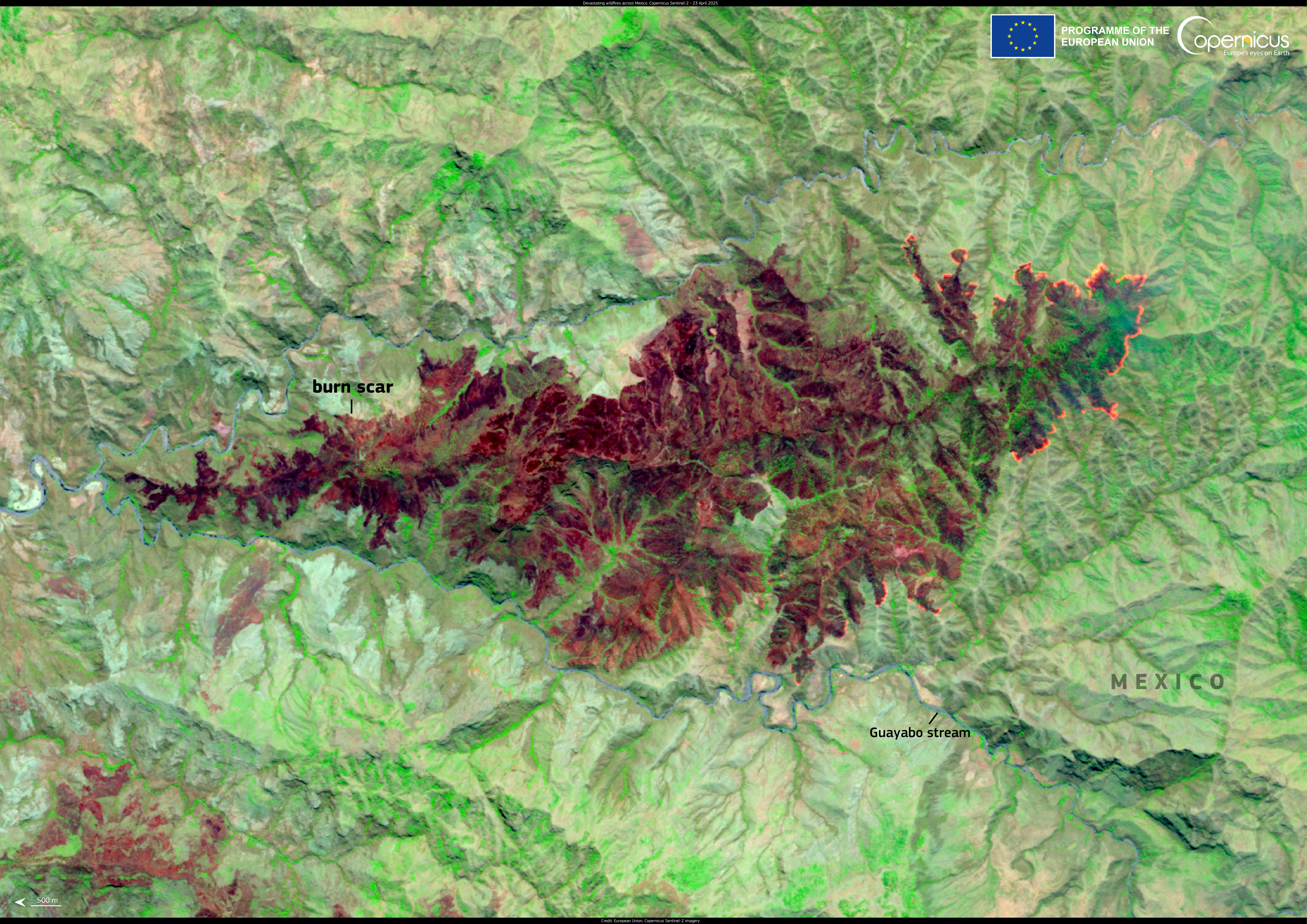
False colour image shows a burn scar from wildfires south of Ciudad Altamirano in the Mexican state of Guerrero on 23 April 2025. Credit: European Union, Copernicus Sentinel-2 imagery
Copernicus Services: Turning Data into Action for Disaster Risk Reduction
The true value of Copernicus lies not only in its data, but in the services which transform this information into actionable insight. The Copernicus Emergency Management Service (CEMS) exemplifies this mission by supporting all phases of disaster management, from preparedness and response to recovery and long-term risk reduction.
CEMS provides on-demand rapid risk mapping products, as well as early warning systems which monitor floods, wildfires, and droughts worldwide. For example, the Global Flood Awareness System (GloFAS) issues forecasts for river flooding up to 30 days in advance, giving authorities time to activate emergency plans. The Global Drought Observatory (GDO) tracks drought conditions and impacts on agriculture, supporting early action before crops fail.
Meanwhile, the Global Wildfire Information System (GWIS), a joint initiative of the Group on Earth Observations (GEO), NASA, and Copernicus, monitors fire danger and activity worldwide. In the Latin America and Caribbean (LAC) region, GWIS is involved in the Support to Forest Fire Management in Latin America and the Caribbean project, a collaboration between the European Union and regional partners aimed at strengthening national wildfire prevention and management capacities through shared expertise and best practices.
Equally important are the tools which provide data on populations exposed to disasters. By integrating census and satellite data, the Global Human Settlement Layer (GHSL), allows to better understand urbanisation patterns and how population density influence exposure to hazards.
CopernicusLAC Panama: A Regional Hub for Resilience
Latin America and the Caribbean is among the most disaster-prone regions in the world, exposed to events such as floods, droughts, hurricanes, earthquakes, volcanic eruptions, and wildfires. According to the UN Office for Disaster Risk Reduction (UNDRR) 2024 Regional Assessment Report for the Americas (RAR24), six of the ten countries with the highest economic losses from disasters relative to GDP are in this region.
As part of this effort, the CopernicusLAC Panama Centre serves as a regional hub for communities and individuals seeking to leverage free and open Copernicus data to address disaster risk reduction and climate change-related challenges. It empowers local authorities to make informed decisions and to plan more effectively for the future.
Through its work, the Centre is co-developing tailored EO services for hydrometeorological, geological and wildfire hazards, as well as for exposure and value mapping. These services are designed to support emergency management stakeholders to better anticipate, prevent, and recover from disasters. One example is the Landslide Susceptibility and Hazard service, which combines data from the Sentinel missions with local information and machine learning techniques to forecast potential landslide zones. Having completed its development stage, the service now entered its demonstration phase. Its outputs are meant to help identify communities at risk and supports targeted mitigation efforts.
![]()
Pixel-based landslide susceptibility map of an area in Peru. Each pixel is colour-coded according to the estimated susceptibility, ranging from green (low, 0) to red (high, 1).Credit: CopernicusLAC Panama Centre
Moreover, the wildfire services focus on supporting wildfire risk management through the detection, monitoring, and analysis of active fires, fire danger and post-disaster recovery. One of these products is the Fire Danger Mapping service, which provides a qualitative fire danger index per pixel analysed through the combination of environmental variables which are key contributors for fire ignition and propagation. This service has successfully completed its development phase and is now in its demonstration stage.
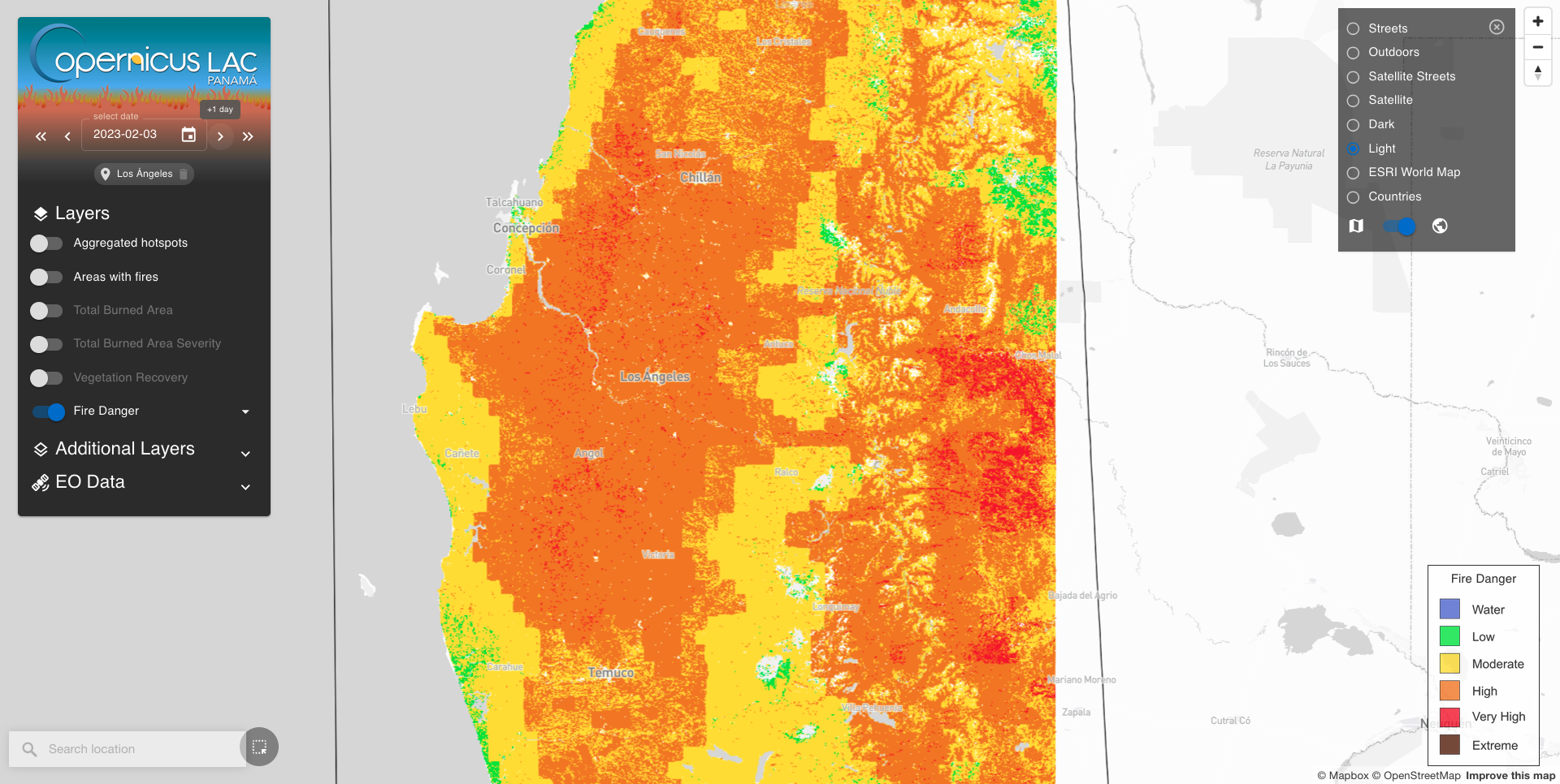
Visualisation of a fire danger map for an area near Los Ángeles, Chile, on 3 February 2023. Credit: CopernicusLAC Panama Centre.
Beyond service development, the CopernicusLAC Panama Centre acts as a catalyst for community engagement. It hosts policy dialogues, private sector support, trainings and hackathons to strengthen regional capacity and stimulate innovation. In August 2025, the Centre hosted its second hackathon, where participants were challenged to address key issues such as urban resilience and disaster preparedness using Copernicus data. The winning project, Comunidades Satélites, proposed a platform which integrates satellite-based monitoring with territorial analysis to anticipate risks, issue alerts and promote sustainable urban growth. Learn more here.
By supporting the adoption of Copernicus capabilities across the region, the Centre helps governments, civil society, and technical experts translate data into preparedness and resilience.
At the Global Platform for Disaster Risk Reduction (GPDRR), the Centre’s commitment was highlighted through an official statement delivered by our Stakeholder Liaison Officer, Claudia Herrera. Published as part of the event proceedings, her message underscored the transformative power of Earth Observation data in strengthening resilience and reaffirmed the Centre’s mission to support disaster risk reduction across the region.
Background Information
The activities of the Centre fall within the overall context of the EU-LAC Digital Alliance, which is a strategic framework to promote cooperation between the European Union (EU) and the Latin America and Caribbean (LAC) region on digital and space issues under the umbrella of the EU Global Gateway strategy. In this context, the European Space Agency (ESA) coordinates the implementation of the Centre on the basis of a Contribution Agreement with the Directorate General for International Partnerships (DG INTPA) of the European Commission, and in close collaboration with the Government of Panama, the MIRE (Ministry of Foreign Affairs), the AIG (Government Innovation Authority), and the SENACYT (National Secretariat for Science, Technology and Innovation).