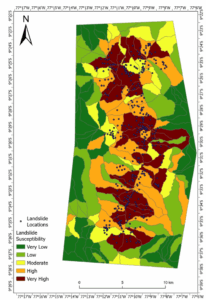
In this use case, an online tool will be provided for leveraging Copernicus Sentinel-2 data and Machine Learning to estimate the likelihood of landslides per pixel. The product is a landslide susceptibility map which can be generated on-demand anywhere in the Latin American and Caribbean region. This landslide susceptibility map can subsequently be reclassified into a landslide hazard map by overlaying ground motion rates from Interferometric Synthetic Aperture Radar (InSAR) methodologies.
Area of application: Peru

Customised landslide susceptibility map over Chavín de Huántar (Peru). Legend: qualitative classes of Landslide susceptibility, from Very Low (greener colors) to Very High (brown color). Credits: Geoapp


