The Earth’s surface is constantly changing because of geological events such as earthquakes, volcanic eruptions, and tectonic plate movement. These processes often trigger natural hazards such as landslides, tsunamis, snow avalanches, rock or debris flows, and subsidence phenomena, causing thousands of casualties and severe economic losses.
Subsidence represents the downward displacement of the Earth’s surface caused by changes in the properties of subsoil materials and the redistribution of underground mass. It represents a significant threat to important infrastructure and urban environments, especially in coastal areas, where accelerated sinking rates increase the risk of flooding. When combined with rising sea levels, subsidence can worsen the damage caused by hurricanes and other natural disasters.
To mitigate these risks, policymakers and disaster management authorities need to make informed and data-driven decisions. This requires, first, understanding the hazards, which often involve long-term processes such as ground movement and, second, addressing real-time operational challenges.
Copernicus EO products and solutions for Subsidence
The Copernicus Earth Observation (EO) Programme, part of the EU’s Space Programme, enables the monitoring of the Earth’s surface at both regional and global scales.
Copernicus’ ability to monitor ground deformation comes from the Sentinel-1 satellites, which are equipped with a Synthetic Aperture Radar (SAR) sensor, making it possible to acquire radar imagery in all weather conditions, day and night. By comparing multiple SAR acquisitions over time, a technique known as SAR Interferometry (InSAR), small ground displacements can be detected with high precision. This data, when combined with other techniques, such as geophysical models, enable fundamental insights into the processes occurring beneath the Earth’s surface.
Beyond the satellite data, Copernicus Services add value by integrating in-situ measurements and modelling. The Copernicus Emergency Management Service (CEMS), for example, provides rapid, on-demand mapping products during and after disasters including storms, earthquakes, volcanic eruptions, which can trigger sudden ground movement and landslides. Once activated, CEMS delivers detailed satellite-based maps that include grading maps to assess damage severity (e.g. identifying landslides after an event) and provide essential information for logistics and on-the-ground coordination. In addition to emergency response, CEMS complements local early warning systems and supports long-term recovery planning with risk and exposure products, such as landslide susceptibility maps.
Subsidence in Latin America and the Caribbean
Subsidence in the Latin America and Caribbean (LAC) region can result from both natural and human-induced factors. Drivers include volcanic activities, tectonic shifts, landslides, mining, large-scale construction, and excessive groundwater extraction, all of which can induce a ground deformation.
In particular, the region’s vulnerability is marked by its location along the Pacific Ring of Fire, one of the world’s most active zones of tectonic interaction. The collision and shifting of plates have not only given rise to several mountain ranges and volcanoes, but they have also unleashed volcanic eruptions and earthquakes with severe, sometimes catastrophic, impacts.
One of the most significant events occurred in Chile on the 22nd of May 1960, when the country was hit by the strongest earthquake ever instrumentally recorded, with a magnitude of 9.5. The earthquake generated a trans-Pacific tsunami which caused damage and loss of life as far away as Hawaii and Japan, while in Chile it resulted in 1,655 deaths, left around two million people homeless, and caused widespread destruction across the south of the country.
More recently, on 8 July 2025, a series of earthquakes struck about 20 km from Guatemala City, affecting an estimated three million people. The strongest tremor, of magnitude 5.6, triggered multiple hazards including landslides, movement of ground material and infrastructure damage.
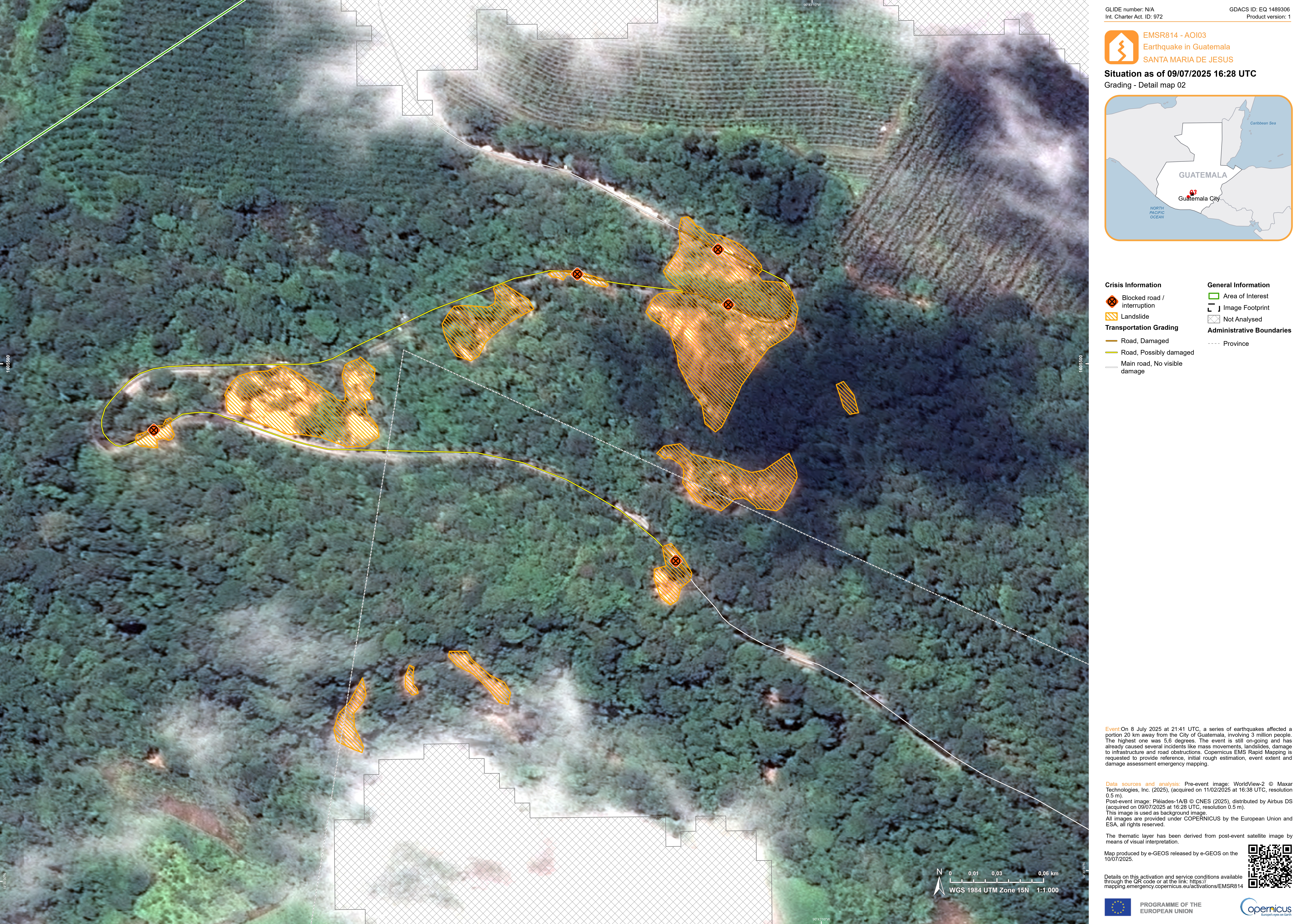
In response, the CEMS On-Demand Mapping service was activated (EMSR814) to produce reference maps, initial damage estimates, event extent maps, and detailed grading maps. Using 28 satellite images, the team estimated that in 15 areas of interest, over 94.5 hectares of landslides occurred, 3 km of roads were affected, and six buildings were damaged. These rapid assessments enabled local authorities to coordinate emergency response and prioritise recovery efforts.

Damage grading product for the Santa María de Jesús municipality, Guatemala, following the 5.6 earthquake on 8 July 2025. Credit: European Union, Copernicus Emergency Management Service, 2025.
The role of the CopernicusLAC Panama Centre
The CopernicusLAC Panama Centre serves as a hub for communities, institutions, and individuals interested in leveraging the free and open Copernicus data to support disaster risk reduction efforts and address the pressing challenges of climate change.
In the context of subsidence, the Centre plays a key role through its Terrain Motion Services under its Geological Hazards Theme, which applies Copernicus Sentinel-1 data and InSAR techniques to monitor and assess ground movement. On of these services is the Surface Motion Mapping (SNAPPING – IFG, PSI), which delivers average surface motion rates and time series in both vertical (up–down) and horizontal (east–west) directions. For example, SNAPPING data can monitor the inflation of a volcano, caused by magma or hydrothermal fluids accumulating beneath the surface, prior to an eruption.

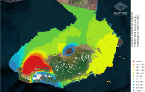
SNAPPING average motion rates over a two-year period (2016-2018) prior eruption event of Sierra Negra Volcano, Galapagos, Ecuador. Credit: Aristotle University of Thessaloniki (AUTh) and the Geohazards Exploitation Platform (GEP).
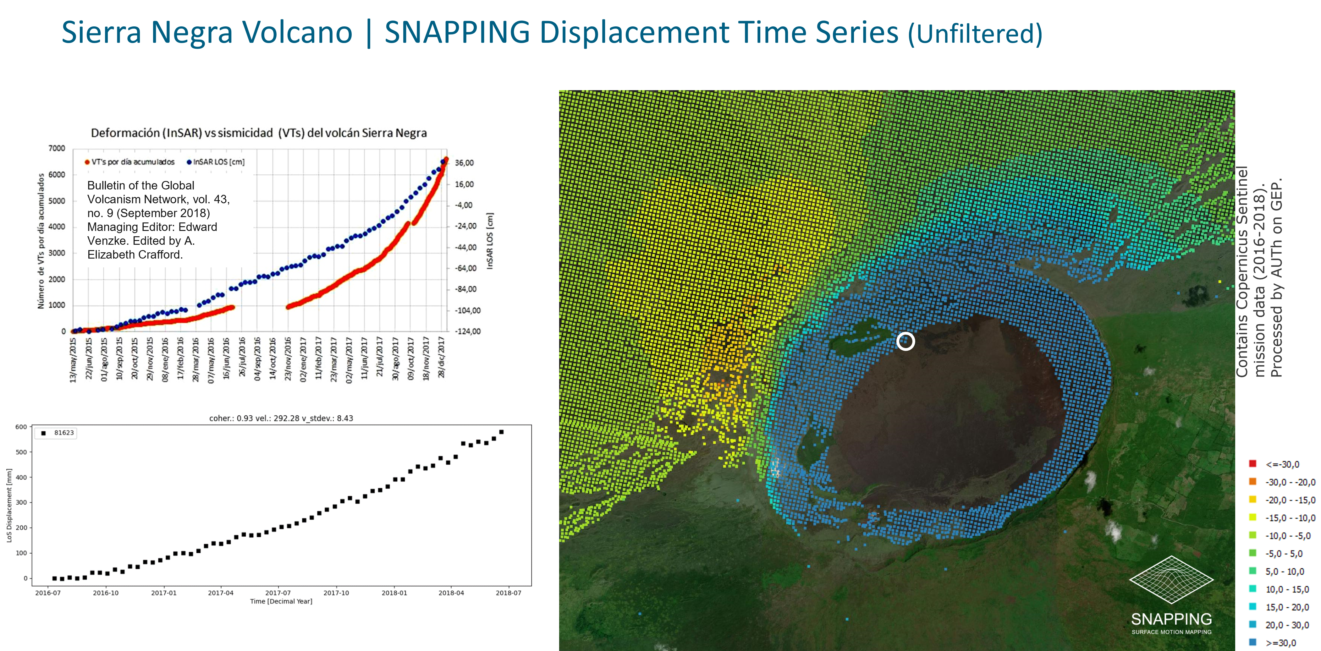
The following figure presents SNAPPING displacement time series of the caldera floor over a 2-year period (2016-2018) (points in black). These findings align closely with previous studies, where InSAR-derived deformation of the caldera floor (points in blue) was found to coincide with an increase in the number of recorded earthquakes, represented by the orange line (cumulative volcano-tectonic earthquakes) for the 2015-2017 period.

SNAPPING displacement time series over a two-year period (2016 -2018) prior eruption event of Sierra Negra Volcano, Galapagos, Ecuador. Credit: Aristotle University of Thessaloniki (AUTh) and the Geohazards Exploitation Platform (GEP).
The Centre’s Exposure Services are complementary and serve to quantify the impacts of geological hazards, such as subsidence and landslides, on populations and infrastructure, producing data which is key for urban planning, disaster preparedness, and infrastructure resilience.
Additionally, the Centre promotes capacity building through its Digital Campus, which provides practical training resources for free. Registered users can access past courses such as “Remote Sensing Applied to Disaster Risks”, which provides both theoretical and practical guidance on monitoring hazards like volcanoes and landslides, with the aim of strengthening early warning systems and enhancing disaster resilience strategies.
Background Information
The activities of the Centre fall within the overall context of the EU-LAC Digital Alliance, which is a strategic framework to promote cooperation between the European Union (EU) and the LAC region on digital and space issues under the umbrella of the EU Global Gateway strategy. In this context, the European Space Agency (ESA) coordinates the implementation of the Centre on the basis of a Contribution Agreement with the Directorate General for International Partnerships (DG INTPA) of the European Commission, and in close collaboration with the Government of Panama, the MIRE (Ministry of Foreign Affairs) and the SENACYT (National Secretariat for Science, Technology and Innovation).
The CopernicusLAC Panama Centre will serve as a platform for innovation in the Latin America and Caribbean region, supporting national and local entities in leveraging Copernicus data and information to enhance socio-economic benefits and resilience. The Centre provides opportunities for engagement and is developing tailor-made EO Services (addressing hydrometeorological hazards, geological hazards and risk exposure services), which are developed in close collaboration with local users and stakeholders, to whom they will be delivered to ensure that the unique needs of the region are addressed in the long term.
In addition, knowledge and skills transfer is a key element of the CopernicusLAC Panama Centre, which hosts a Digital Campus with access to training modules and educational resources for technical users and citizens alike. The Centre will also organise community-building events, policy dialogues and industry matchmaking, as well as hackathons and other Earth observation (EO) data challenges to stimulate user adoption of Copernicus data and innovation. These events will also foster cross-collaboration of EO, Disaster Risk Reduction (DRR) and other relevant ecosystems.
Finally, the Centre will include the development of high-powered infrastructure and cloud computing for the LAC region. One of the ultimate objectives of the Centre is also to promote the development of communities of practice and strengthen capacities in the public sector, academia, the private sector and within social organisations in the knowledge and use of tools for DRR and other areas.


