


Date: 6 December 2022
Location: Lima, Peru
Credit: Copernicus Sentinel-2 image, processed by the CopernicusLAC Panama Centre
Description:
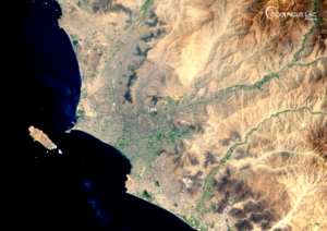
This Copernicus Sentinel-2 image, acquired on 6 December 2022, shows Lima, the capital of Peru.
Since December 2024, Peru has been affected by heavy rainfall, leading to floods and landslides which had affected more than 168,000 people as of 14 March 2025. The country’s geography makes it especially prone to flooding and landslides, with these events accounting for approximately half of hazard occurrences between 1980 and 2020.
In this context, Peru has been selected as a demonstration site for the pre-operational phase of the Landslide Susceptibility Mapping EO Service of the CopernicusLAC Panama Centre, developed within the Geological Hazards Theme. The service will strengthen the Latin America and Caribbean (LAC) region’s capabilities related to landslide exposure and impact assessments, thereby supporting its overall resilience to these types of events. More information about the service is available here.
Peru is also one of the areas of application for the Centre’s “Flood hazard with hydrological modelling and Earth Observation” use case, developed within the Hydrometeorological Hazards Theme. The services applied in this use case will allow for improved preparedness and disaster risk reduction related to floods. More information about these activities is available here.
To stay up to date on future training courses and opportunities from the CopernicusLAC Panama Centre, follow us on LinkedIn, Instagram, and X, and subscribe to our newsletter!
Background Information
The Copernicus LAC Panama Centre’s activities take place within the overall context of the EU-LAC Digital Alliance, which is a strategic framework for promoting cooperation between the EU and the LAC region on digital and space issues under the EU Global Gateway umbrella. Within this context, the European Space Agency (ESA) is coordinating the Centre’s implementation on the basis of a Contribution Agreement with the Directorate-General for International Partnerships (DG INTPA) of the European Commission, and in close collaboration with Panama’s government, MIRE (Ministry of Foreign Affairs), Government Innovation Authority (AIG), and SENACYT (National Secretariat for Science, Technology and Innovation).
The CopernicusLAC Panama Centre will serve as a hub for innovation in the Latin America and Caribbean region, supporting national and local entities in leveraging Copernicus data and information to boost socio-economic benefits and resilience. In addition to providing engagement opportunities, the Centre is developing geospatial Disaster Risk Reduction (DRR) Pilot Services (addressing hydrometeorological hazards, geological hazards, and hazard exposure) in close collaboration with local users and stakeholders, to whom they will be handed over to ensure that the unique needs of the region are addressed in the long term.
In addition, knowledge and skills transfer is a key element of the CopernicusLAC Panama Centre, which hosts a Digital Campus with access to training modules and educational resources for technical users and citizens alike. The Centre will also organise community-building events, policy dialogues and industry matchmaking, as well as hackathons and other Earth Observation (EO) data challenges to stimulate user adoption of Copernicus data and innovation. These events will also foster cross-collaboration among EO, disaster risk reduction (DRR) and other relevant ecosystems.
Finally, the Centre will support the development of a high-power computing and data storage cloud infrastructure for the LAC region. One of the final objectives of the Centre is to promote the development of communities of practice and to strengthen the knowledge and use of tools for DRR and other application areas in the public sector, academia, the private sector, and social organisations.