


Date: 19 July 2024
Location: Bogota, Colombia
Credit: Copernicus Sentinel-2 image, processed by the CopernicusLAC Panama Centre
Description:
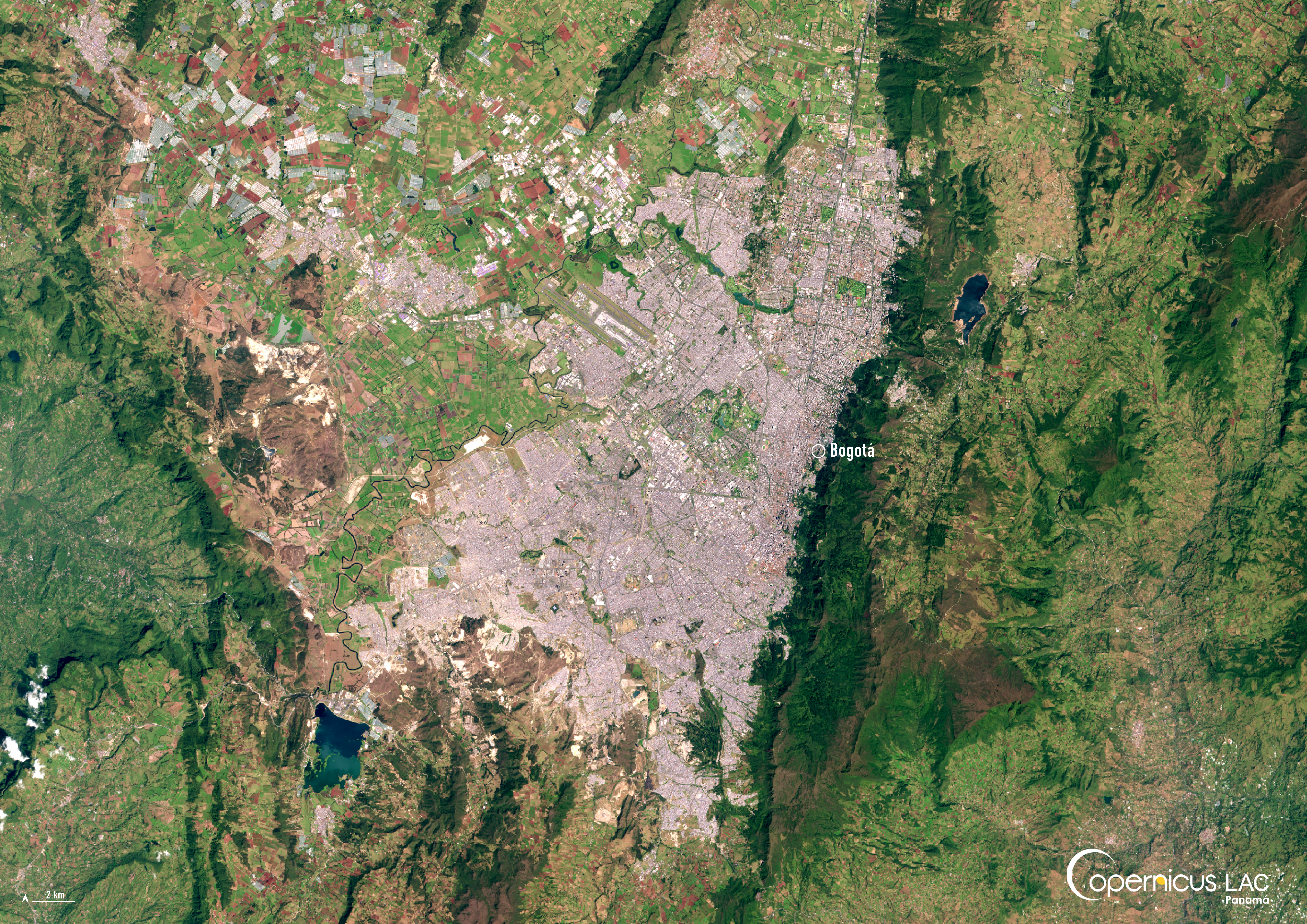
This image, acquired by one of the Copernicus Sentinel-2 satellites on 23 January 2024, shows Bogota, the bustling capital of Colombia.
Situated at an elevation of 2,640 metres above sea level, Bogota is surrounded by green hills and valleys and characterised by a relatively cool climate, despite its location near the equator. With a population of over 7 million people, the city serves as Colombia’s political, economic and cultural hub.
Bogota is also the site of the CopernicusLAC Panama Centre in-person training course “Applications of Remote Sensing for Flood Risk”, taking place from 24 to 28 March 2025.
Through the course, participants explore the use of Copernicus satellite data, including optical and synthetic aperture radar (SAR) imagery data, for disaster risk reduction related to flooding. This includes identifying regions vulnerable to flooding events, mapping affected areas as these events occur, and carrying out damage assessments in their aftermath. Participants further gain hands-on experience in processing and analysing Copernicus data for flooding through the use of specific software and applications. Find more information on the training course here.
The lectures and resources from the training course will be made available for free for all registered users of the Centre’s Digital Campus.
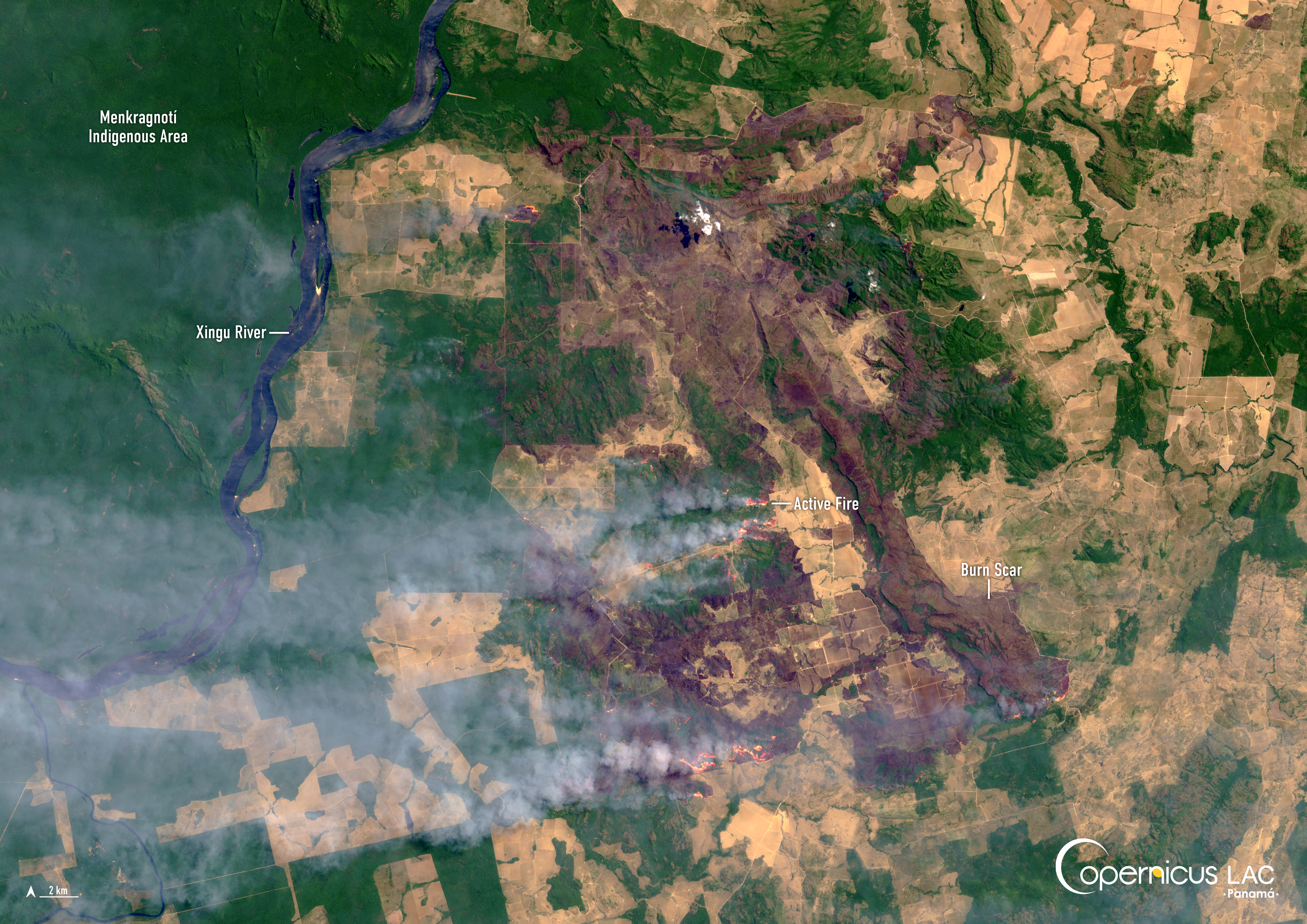
Finally, Colombia has been selected as a pre-operational implementation site during the demonstration phase of the CopernicusLAC pilot service dedicated to wildfires. This service supports local institutions tasked with wildfire management by providing EO-based applications to monitor the risk of forest fires occurring, as well as their evolution and the damage caused. The involvement of institutions in Colombia and other countries is essential to the development of the pilot service. Find more information about this service here and here.
To stay up to date on future training courses and opportunities from the CopernicusLAC Panama Centre, follow us on LinkedIn, Instagram, and X, and subscribe to our newsletter!
Background Information
The Copernicus LAC Panama Centre’s activities take place within the overall context of the EU-LAC Digital Alliance, which is a strategic framework for promoting cooperation between the EU and the LAC region on digital and space issues under the EU Global Gateway umbrella. Within this context, the European Space Agency (ESA) is coordinating the Centre’s implementation on the basis of a Contribution Agreement with the Directorate-General for International Partnerships (DG INTPA) of the European Commission, and in close collaboration with Panama’s government, MIRE (Ministry of Foreign Affairs), Government Innovation Authority (AIG), and SENACYT (National Secretariat for Science, Technology and Innovation).
The CopernicusLAC Panama Centre will serve as a hub for innovation in the Latin America and Caribbean region, supporting national and local entities in leveraging Copernicus data and information to boost socio-economic benefits and resilience. In addition to providing engagement opportunities, the Centre is developing geospatial Disaster Risk Reduction (DRR) Pilot Services (addressing hydrometeorological hazards, geological hazards, and hazard exposure) in close collaboration with local users and stakeholders, to whom they will be handed over to ensure that the unique needs of the region are addressed in the long term.
In addition, knowledge and skills transfer is a key element of the CopernicusLAC Panama Centre, which hosts a Digital Campus with access to training modules and educational resources for technical users and citizens alike. The Centre will also organise community-building events, policy dialogues and industry matchmaking, as well as hackathons and other Earth Observation (EO) data challenges to stimulate user adoption of Copernicus data and innovation. These events will also foster cross-collaboration among EO, disaster risk reduction (DRR) and other relevant ecosystems.
Finally, the Centre will support the development of a high-power computing and data storage cloud infrastructure for the LAC region. One of the final objectives of the Centre is to promote the development of communities of practice and to strengthen the knowledge and use of tools for DRR and other application areas in the public sector, academia, the private sector, and social organisations.