


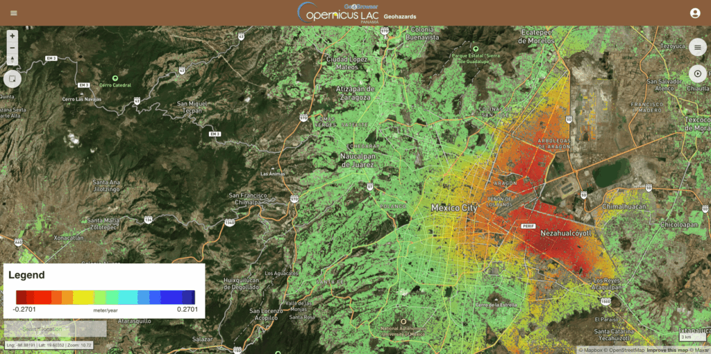
- Mass production of land deformation data
- Land deformation on a medium scale
CopernicusLAC Panama is making progress on new satellite services for monitoring land deformation in Latin America and the Caribbean
The first meetings have been held for two new strategic use cases focusing on monitoring land deformation using Earth Observation data. The aim of these developments is to strengthen institutional capacities for the management of geological hazards risk and to support decision-making based on objective and consistent information for urban planning and resource allocation.
Ground deformation is caused by various factors: tectonic activity, extreme weather events or infrastructure construction, causing significant impacts on people’s safety. Therefore, the aim is to provide user institutions with operational products providing extensive coverage which can be integrated into monitoring systems to support spatial planning and disaster risk reduction.
The services are based on InSAR (Synthetic Aperture Radar Interferometry) techniques, which provide a highly accurate and scalable solution, and on Copernicus Sentinel-1 data. In particular, the development of the following three complementary services is being considered:
- KinesIS Ground Motion Mapping, aimed at obtaining average ground motion rates over large areas using interferometric stacking techniques. This service enables the identification of consistent, long-term regional deformation patterns.
- PSI Monitoring of Ground Motion, through which time series of displacement and average velocities are obtained, to support the analysis of slow and persistent deformations. This service is based on the SNAPPING PSI (Persistent Scatterer Interferometry) processing scheme.
- 3D Geometric Decomposition, a post-processing service that combines the results of the above to estimate the actual vertical and horizontal components of ground motion, thereby simplifying the interpretation of the results by the end user.
Mass production of ground deformation data
This refers to the use case in which these services are applied for the purpose of carrying out a single large-scale data collection exercise, implemented in Guatemala, El Salvador and Costa Rica.
It involves the collaborative participation of various institutions in Guatemala, including the National Institute of Seismology, Volcanology, Meteorology and Hydrology (INSIVUMEH) and the National Co-ordinating Body for Disaster Risk Reduction (CONRED). Also involved are the Institute of Geosciences at the University of Panama, the Ministry of the Environment and Natural Resources of El Salvador, the Volcanological and Seismological Observatory of the National University of Costa Rica, and the Centre for Atmospheric, Oceanographic and Seismic Studies of Honduras, within the Permanent Contingency Commission, and alongside the European Commission’s Directorate-General for Civil Protection and Humanitarian Aid Operations (DG-ECHO). Their participation is key to ensuring that the services meet their actual needs and strengthening regional capacity for hazard monitoring.
Land deformation on a medium scale
This second use case focuses on monitoring ground deformation on a medium scale, applied to regional areas of Mexico and Panama, using the three services mentioned.
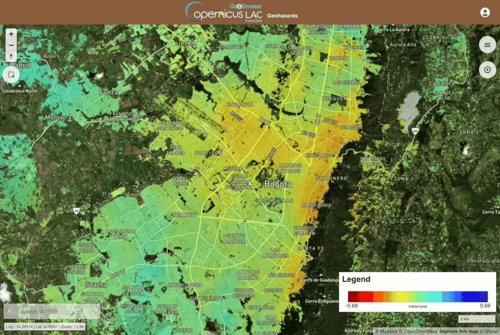
The development of these services involves the participation of numerous Mexican institutions, such as the Mexican Geological Survey (SGM), the National Centre for Prevention (SSPC), the Secretariat for Comprehensive Risk Management and Civil Protection, the National Centre for Disaster Prevention (CENAPRED), the National Forestry Commission, the National Water Information System (CONAGUA-SML), the National Commission for the Knowledge and Use of Biodiversity (CONABIO), the National Council for the Prevention of Discrimination (CONAPRED), the National Meteorological Service, the Autonomous Technological Institute of Mexico (ITAM), the University of Colima, the UNAM Institute of Geosciences and the National Institute of Ecology and Climate Change. In addition, the Panama Canal Authority, the Higher Technological Institute of Ecuador (ISTCRE), the European Commission’s DG-ECHO and the United Nations Development Programme (UNDP) are also participating.
For the relevant authorities, having accurate mapping is crucial for identifying risk areas, thereby enabling the implementation of appropriate mitigation measures.
These developments highlight the role of the CopernicusLAC Centre in Panama as a platform for collaboration between institutions, the scientific community and satellite technology for monitoring land deformation. Through the co-development of these services, access to standardised and accessible information is facilitated; this information is integrated into institutional systems and supports agencies in their decision-making for improved risk management, spatial planning and civil protection.
Background information
The activities of the CopernicusLAC Panama Centre fall within the overall context of the EU-LAC Digital Alliance, which is a strategic framework to promote cooperation between the European Union (EU) and the Latin America and Caribbean (LAC) region on digital and space issues under the umbrella of the EU Global Gateway strategy. In this context, the European Space Agency (ESA) coordinates the implementation of the Centre on the basis of a Contribution Agreement with the Directorate General for International Partnerships (DG INTPA) of the European Commission, and in close collaboration with the Government of Panama, the MIRE (Ministry of Foreign Affairs) and the SENACYT (National Secretariat for Science, Technology and Innovation).
Sign up for our newsletter by registering on the digital campus and follow us on social media to keep up to date with the Centre’s activities.