


Within this use case, on-demand and detailed flood hazard maps for different return periods expressed in terms of flood water depth will be delivered. For this purpose, Copernicus Sentinel-1 and Sentinel-2 data will be integrated into high-resolution hydrological and hydraulic model data.
The services to be demonstrated in this use case are focused on urban areas and will enable the delivery of accurate empirical and modelled flood depth estimates and flood frequency analysis. They will also support impact assessments by specifically targeting building assets and population vulnerability.
Area of application: Bolivia
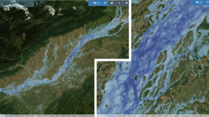
Example of empirical flood frequency product based on the Copernicus Sentinel-1 catalogue. Period of analysis: 2015-2021. Legend: Darker shades of blue identify areas with higher flood frequency. Credits: CIMA Foundation, LIST and WASDI