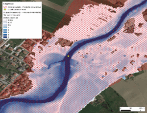
Within this use case hazard mapping and flood forecasting will be provided. Copernicus Emergency Management Service (CEMS) Global Flood Awareness System (GloFAS) and high-resolution flood observations from the Copernicus Sentinel-1 mission data will be used. The services under demonstration will deliver flood extent and water depth maps, flood frequency assessments, and flood probability forecasts. By integrating modelled and empirical data, they will improve the evaluation of flood frequency, particularly for events with shorter return periods, thereby reducing the likelihood of model underestimations.
Areas of application: Central America, Peru, Ecuador

Hazard map developed merging TELEMAC-2D model and adjusted to Earth Observation flood extent. Marche region (Italy), 2023. Legend: Darker shades of blue indicate deeper water. Credits: CIMA foundation


