


Date: 24 August and 24 September 2024
Location: La Paz, Bolivia
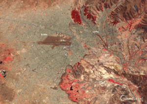
Credit: Copernicus Sentinel-2 image, processed by the CopernicusLAC Panama Centre
Description:
La Paz, Bolivia is shown in this false-colour mosaic of Copernicus Sentinel-2 images acquired on 24 August and 24 September 2024.
Bolivia is highly vulnerable to hydrometeorological hazards, including drought, floods, and forest fires.
The 2024 fire season was one of the most severe to affect the country in many years, leaving behind a devastating impact on ecosystems, wildlife, and local communities.
According to the National Agrarian Reform Institute (INRA), the department of Santa Cruz was the most affected by wildfires, followed by Beni and La Paz. The World Wildlife Fund reports that these fires have severely affected large areas of forest and pastureland, endangering important ecosystems and biodiversity in these regions.
Free and open data from the Copernicus Sentinel satellites serves as an essential resource for tracking the extent of wildfires and assessing their consequences on ecosystems across the Latin American and Caribbean (LAC) region. Read more about the applications of Copernicus data for wildfires in this blog article.
In addition to providing trainings on remote sensing for wildfires – the resources of which are freely accessible via our Digital Campus – the Centre is further developing an Earth Observation service dedicated to wildfires. It will increase the ability of institutions across the LAC region to respond to challenges resulting from wildfires more effectively. More information about the service is available here.
Finally, the Centre also works to promote the protection of biodiversity in the LAC region. One of the three challenges of the 2024 CopernicusLAC Hackathon was “Preserving biodiversity and endangered habitats”, for which participants conceptualised how Copernicus data can be leveraged for these applications. More information about the upcoming CopernicusLAC Hackathon in July 2025 will be available soon.
To stay updated on upcoming trainings and additions of modules to the Digital Campus, be sure to follow our Centre on LinkedIn, Instagram, X, and subscribe to our newsletter.
Background Information
The Copernicus LAC Panama Centre’s activities take place within the overall context of the EU-LAC Digital Alliance, which is a strategic framework for promoting cooperation between the EU and the LAC region on digital and space issues under the EU Global Gateway umbrella. Within this context, the European Space Agency (ESA) is coordinating the Centre’s implementation on the basis of a Contribution Agreement with the Directorate-General for International Partnerships (DG INTPA) of the European Commission, and in close collaboration with Panama’s government, MIRE (Ministry of Foreign Affairs), Government Innovation Authority (AIG), and SENACYT (National Secretariat for Science, Technology and Innovation).
The CopernicusLAC Panama Centre will serve as a hub for innovation in the Latin America and Caribbean region, supporting national and local entities in leveraging Copernicus data and information to boost socio-economic benefits and resilience. In addition to providing engagement opportunities, the Centre is developing geospatial Disaster Risk Reduction (DRR) Pilot Services (addressing hydrometeorological hazards, geological hazards, and hazard exposure) in close collaboration with local users and stakeholders, to whom they will be handed over to ensure that the unique needs of the region are addressed in the long term.
In addition, knowledge and skills transfer is a key element of the CopernicusLAC Panama Centre, which hosts a Digital Campus with access to training modules and educational resources for technical users and citizens alike. The Centre will also organise community-building events, policy dialogues and industry matchmaking, as well as hackathons and other Earth Observation (EO) data challenges to stimulate user adoption of Copernicus data and innovation. These events will also foster cross-collaboration among EO, disaster risk reduction (DRR) and other relevant ecosystems.
Finally, the Centre will support the development of a high-power computing and data storage cloud infrastructure for the LAC region. One of the final objectives of the Centre is to promote the development of communities of practice and to strengthen the knowledge and use of tools for DRR and other application areas in the public sector, academia, the private sector, and social organisations.