


The intensity, duration, and frequency of wildfires are increasing around the globe. This has important consequences for communities living in areas prone to fires, since they can have devastating impacts on the environment, property, and human life. The Latin America and Caribbean (LAC) region is particularly vulnerable to wildfires: in 2023 alone, hundreds of thousands of hectares of land in Central and South America were affected, with Chile, Argentina, Venezuela, Brazil, Guatemala, Belize, and Bolivia most impacted.
Most fires in the LAC region are caused by human activities, with a large portion of wildfires driven by tropical deforestation. Local conditions, such as large, dense forests of non-native, combustible tree species, can further contribute to more frequent or more severe wildfires. This trend is also being driven in recent years by climate change, which can lead to prolonged drought and higher temperatures.
This article explores how Copernicus Earth Observation (EO) satellite data and Services have helped local authorities respond to wildfires in the LAC region and better understand the broader impacts of fire activity. It further discusses how the CopernicusLAC Panama Centre will support communities in the LAC region in increasing resilience to wildfires.
The role of Copernicus EO satellite data and Services
Copernicus satellite data and the value-added information delivered by the Copernicus Services are used before, during, and after wildfires to obtain insights about the risk of wildfires in a given area, the amount of land, property, or individuals affected by a fire, or to estimate the emissions of pollutants and particles which result from a fire.
Copernicus is served by a set of dedicated satellites (the Sentinel family) and Contributing Missions (existing commercial and public satellites). The Copernicus Sentinel satellites deliver free and open data with high temporal and spatial resolutions which allow for the continual monitoring of fire activity regardless of the extent or morphology of the area of interest. The Copernicus Services then transform satellite and in situ data into value-added information by processing and analysing them.
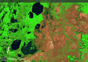
Copernicus Sentinel-2 image acquired on 4 July 2024, showing wildfires in Pantanal, the world’s largest wetland, most of which is in Brazil. The dark red areas of the image are burn scars. Credit: European Union, Copernicus Sentinel-2, 2024.
Fire danger forecasts published by the Global Wildfire Information System (GWIS) allow policymakers and communities to better understand the risk of fires in a given area, including in the LAC region. GWIS is a collaborative initiative of the European Union, NASA, the Group on Earth Observations (GEO), and Copernicus to integrate regional and national fire information, providing a global perspective on fire regimes and fire impacts, as well as tools for wildfire management. Among its applications, GWIS provides fire danger forecasts up to ten days in advance, as well as information on active fires. It also provides statistics at the national level for regions of interest based on detected wildfire activity. By leveraging GWIS, the EU also supports the “Support to Wildfire Management in the LAC region” project, composed of two complementary programmes working to reduce the impact of wildfires in the Amazon and neighbouring countries through collaboration with LAC countries and international organisations. The following map published by the European Commission’s Directorate-General for Civil Protection and Humanitarian Aid Operations’ (DG ECHO) Emergency Response Coordination Centre (ERCC) on 6 June 2024 leverages GWIS data to show wildfire activity in Belize, Honduras, and Guatemala.
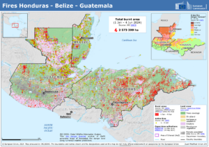
DG ECHO’s ERCC Daily Map of 6 June showing the wildfire situation across Guatemala, Belize, and Honduras between 1 January and 4 June 2024. Credit: European Union, DG ECHO, ERCC, 2024.
During wildfire activity, the Copernicus Atmosphere Monitoring Service (CAMS), through its Global Fire Assimilation System, delivers data on wildfires’ distribution, intensity, and corresponding emissions into the atmosphere. CAMS provides forecasts on the transport of smoke in the atmosphere, helping affected communities to limit their exposure to harmful pollutants.
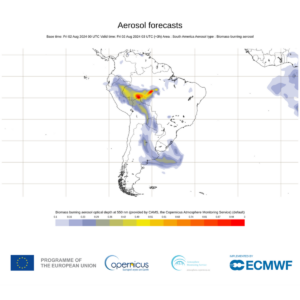
Daily forecast from 2 August 2024 showing Biomass Burning Aerosol Optical Depth, a measure of how much sunlight is able to pass through the atmosphere, indicating the amount of particulate matter in wildfire smoke plumes. Credit: European Union, Copernicus Atmosphere Monitoring Service, 2024.
Another useful resource is the Sentinel-3 World Fire Atlas, developed by the European Space Agency, which detects night-time fires and other high-temperature events around the world by leveraging data from the Copernicus Sentinel-3A satellite. The Atlas provides maps and statistics on fire events which can be filtered by country or area of interest and time range, providing comprehensive data on night-time fire activity.
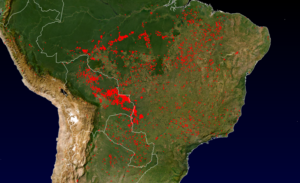
High-temperature hot spots detected by Sentinel-3A in part of South America between 1 June and 14 August 2024. Credit: European Union, Sentinel-3 World Fire Atlas, provided by the European Space Agency, 2024.
The timely geospatial information and mapping products provided by the Copernicus Emergency Management Service (CEMS) further deliver key information related to wildfires. In the first half of 2024, fires ravaged parts of Central America, mostly affecting Mexico, Guatemala, and Belize. Between April and June 2024, the CEMS On-Demand Mapping team was activated three times to deliver preliminary estimates, fire extent, and damage assessments of specific wildfires in these countries. Among the three countries, 68 mapping products were delivered during the wildfire activity, detecting a total burnt area of over 2,270 square kilometres, over three times the size of Guatemala City.
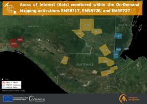
Areas of Interest (AoIs) monitored by the Copernicus EMS Mapping team as part of the EMSR717 (Wildfires in Mexico), EMSR726 (Wildfires in Belize), and EMSR727 (Wildfires in Guatemala) On-Demand Mapping activations. Credit: European Union, Copernicus Emergency Management Service, 2024.
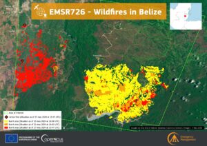
Temporal evolution data visualisation of the burnt area in the Douglas da Silva Area of Interest in Belize (EMSR726) based on data from the products released by the Copernicus EMS On-Demand Mapping component between 23 and 27 May 2024. Credit: European Union, Copernicus Emergency Management Service, 2024.
Separately, in February 2024, the Chilean president declared a State of Emergency as the country’s deadliest forest fire on record affected the Valparaiso region. In addition to activating the CEMS On-Demand Mapping service to support emergency response activities, DG ECHO, on behalf of Chile’s National Forestry Corporation (CONAF) also requested support during the recovery phase, providing a detailed damage assessment, human settlements mapping, and other assessments, including a quantification of the buildings, roads, and types of vegetation affected.
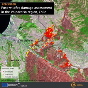
Damage assessment of the Valparaíso Area of Interest (AoI), Chile, as of 12 February 2024. The assessment shows that 5,694 buildings were completely destroyed by wildfire activity. Credit: European Union, Copernicus Emergency Management Service, 2024.
Information provided by Copernicus EMS is important for helping emergency responders and disaster management teams address wildfires more efficiently. By having a more comprehensive understanding of the areas affected and the damage caused by wildfire activity, more informed decisions regarding the allocation of resources or evacuation of residents can be made. This helps protect the health and well-being of local communities and ecosystems and ensures a more efficient recovery.
Looking forward: the role of the CopernicusLAC Panama Centre
As the warming climate stands to cause an increase in the frequency and intensity of wildfires, Copernicus data will play an even more important role in helping public authorities and local communities to respond to wildfires and to understand long-term trends in fire activity in the LAC region.
In this context, the CopernicusLAC Panama Centre serves as a hub for communities and individuals interested in leveraging Copernicus free and open data for disaster risk reduction or for tackling climate change-related issues.
By hosting political dialogues, hackathons, workshops, and community events, and by providing trainings and educational resources on EO data, including on applications related to wildfires, the Centre acts as a focal point for community engagement and capacity building on these topics.
To complement these existing activities, and to support the further development of local capabilities and capacity building, the CopernicusLAC Panama Centre will develop three streams of EO-based pilot services which will be handed over to local stakeholders for continued implementation after the end of the pilot demonstration phase. In addition to a geological hazards service and an exposure service, the Centre will support the development of a hydrometeorological service, which will focus on leveraging Copernicus data to help public authorities strengthen their early warning capabilities in relation to events such as wildfires, floods, or drought. This data can support preparedness and prevention activities, thereby increasing resilience to such events.
Finally, in parallel to aforementioned activities it is also foreseen technical assistance and development of tools for scoping, designing and the initial setup of a Copernicus Data Centre in Panama which will ensure a privileged access to Copernicus data to users in the region.
To ensure that the unique needs, requirements, gaps, and priorities of the region underpin the development and direction of the pilot services, their development is based on stakeholder consultations and will be assessed for validity through various use cases.
Through these activities, the CopernicusLAC Panama Centre will increase the resilience of the LAC region to wildfires.
Background Information
The Copernicus LAC Panama Centre’s activities take place within the overall context of the EU-LAC Digital Alliance, which is a strategic framework for promoting cooperation between the EU and the LAC region on digital and space issues under the EU Global Gateway umbrella. Within this context, the European Space Agency (ESA) is coordinating the Centre’s implementation on the basis of a Contribution Agreement with the Directorate-General for International Partnerships (DG INTPA) of the European Commission, and in close collaboration with Panama’s government, MIRE (Ministry of Foreign Affairs), Government Innovation Authority (AIG), and SENACYT (National Secretariat for Science, Technology and Innovation).