


The CopernicusLAC Panama Centre has announced the successful completion of the development phase of Use Case 6 on “Wildfires: Mapping events, danger and recovery”. This milestone has resulted in the creation of three open-source services designed to support comprehensive wildfire risk management:
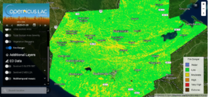
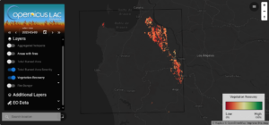
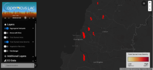
- Fire Danger Mapping (FDM): A service which generates maps to assess wildfire danger in specific regions.
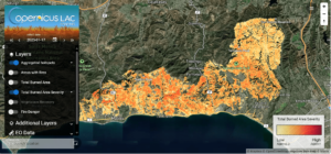
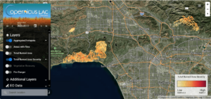
- Burned Area Mapping (BAM): A service for high-precision identification and mapping of areas affected by wildfires.
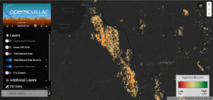
- Fire Recovery Mapping (FRM): A service focused on analysing ecosystem recovery following wildfires.
These services will provide practical and accessible solutions for institutions tasked with wildfire and disaster management across the Latin America and Caribbean (LAC) region.
Use Case 6 will now move to a demonstration phase, scheduled to span three months during the 2024-2025 wildfire season. This phase will allow the project team to validate the services’ operational capabilities and demonstrate their value in real-world settings.
The demonstration phase will feature:
- Pre-operational implementation in Colombia and Central America: The services will be deployed to monitor and manage wildfires during the demonstration period.
- Automated, systematic execution: The underlying algorithms will process data automatically, showcasing their efficiency and accuracy.
- Collaborative access: The services will be hosted on the CopernicusLAC Panama Centre platform, where users will be able to explore results in a dedicated workspace by viewing maps, downloading data, and suggesting improvements for future iterations.
Institutions from Colombia, Honduras, and Guatemala which were involved in the development phase, as well as other organisations from the region, will have access to the services via the CopernicusLAC Panama Centre platform, where they can engage with the tools, provide feedback, and contribute to the ongoing refinement of the services.
Feedback from users during this phase will play a key role in improving the services ahead of their operational rollout.
Additionally, in-person training part of the demonstration phase. The training will focus on:
- Explaining the functionality of the three services
- Detailing the algorithms behind the tools and their outputs
- Showcasing the potential applications of these tools for wildfire management
Participants will also discuss how to integrate the services into their institutional workflows, ensuring seamless adoption and long-term sustainability. More information about the training sessions is coming soon.
Use Case 6 represents a significant advancement in wildfire risk management for the LAC region. The three services developed under this initiative are expected to increase the ability of local institutions to address wildfire challenges effectively.
Background Information
The Copernicus LAC Panama Centre’s activities take place within the overall context of the EU-LAC Digital Alliance, which is a strategic framework for promoting cooperation between the EU and the LAC region on digital and space issues under the EU Global Gateway umbrella. Within this context, the European Space Agency (ESA) is coordinating the Centre’s implementation on the basis of a Contribution Agreement with the Directorate-General for International Partnerships (DG INTPA) of the European Commission, and in close collaboration with Panama’s government, MIRE (Ministry of Foreign Affairs), Government Innovation Authority (AIG), and SENACYT (National Secretariat for Science, Technology and Innovation).