


Flooding events are one of the most frequent types of disasters and affect millions of people every year. The consequences of floods range from affected crops, thereby compromising food security, to damaged infrastructure or loss of human life.
Deforestation, wildfires, and urbanisation are all factors contributing to flood risk. When vegetation is removed, the soil loses its natural ability to absorb water, increasing runoff into rivers and eventually reaching urban areas. In cities, impermeable surfaces increase the risk by blocking infiltration and often overloading drainage systems, especially as heavy rainfall events become more frequent and intense as a consequence of climate change. Effective urban planning, resilient infrastructure, and timely weather forecasting are therefore essential to reduce impacts and protect communities.
In this context, there is an increasing need to adopt data-driven prevention and mitigation strategies, including evidence-based land management and the use of forecasting tools to anticipate and respond to extreme weather events more effectively.
Copernicus Sentinel satellites and Copernicus Services
Copernicus, the Earth Observation (EO) component of the EU’s Space Programme, provides free and open data from its satellites (Sentinels) as well as via the Copernicus Services with high temporal and spatial resolution across the globe.
For instance, the data provided by the Copernicus Sentinel-2 satellites is key to monitoring rivers, reservoirs, and cities, tracking these environments to assess potential flood damage and plan recovery operations for affected areas. At the same time, data provided by Copernicus Sentinel-1 makes it possible to identify water bodies and observe the extent of flooding during the day, at night and even in unstable atmospheric conditions, which may coincide with extreme phenomena triggering these flood events (such as storms or hurricanes).
In addition, Copernicus Services, which integrate data from satellites, models and in situ data, provide relevant products related to atmosphere, climate change, oceans, and land monitoring, as well as for supporting emergency management activities.
The reference service for flood preparedness, response, and recovery activities is the Copernicus Emergency Management Service (CEMS), delivering key and timely geospatial information through three components:
- Early Warning and Monitoring: Including the Global Flood Awareness System (GloFAS), which provides global probabilistic hydrological forecasts (days to months) and the Global Flood Monitoring (GFM), which provides flood extent information thanks to an automated processing of all the incoming Copernicus Sentinel-1 radar imagery.
- On-Demand Mapping: This component provides timely geospatial products following a formal activation. It supports stakeholders in emergency management before, during and after flood events. This service delivers risk analyses and assessments before and after flood events, as well as monitoring flood extent and providing damage assessments in their immediate aftermath.
- Exposure Mapping: Through the Global Human Settlement Layer (GHSL), which combines satellite data with census data, it is possible to access a wide range of datasets which help map and identify vulnerable populations and infrastructure, granting crucial insights for risk reduction and long-term planning.
The effective use of Copernicus data improves the immediate response and strengthens the resilience of affected communities, serving as a strategic reference for national authorities, humanitarian agencies, and civil protection stakeholders across the globe, including the Latin America and Caribbean (LAC) region.
Use cases in flood management in Latin America and the Caribbean
Extreme weather events are becoming more frequent and severe, also in the LAC region, which is already highly vulnerable to hurricanes and floods, as well as to wildfires, and prolonged droughts, which in turn increase the risk of flooding due to exposed land cover. Copernicus has provided data before, during, and after these events.
For instance, 300 mm of rain fell in the mountains of northern Rio Grande do Sul State in Brazil on 31 April 2024, causing dam breaks and landslides, and submerging entire towns. Over 160 people lost their lives as the floodwaters headed south towards the Guaíba drainage basin, where the streams from the northern third of the state converge and flow directly past the centre of Porto Alegre.
In response, the CEMS On-Demand Mapping component was activated by the European Commission’s Directorate-General for European Civil Protection and Humanitarian Aid Operations (DG ECHO) for monitoring and assessing the impact of the event in the state of Rio Grande do Sul, Brazil.
Within the activation of EMSN194, the On-Demand Mapping team delivered several geospatial products, including:
- Flood delineation maps
- Temporal analysis of flood events
- Detailed damage assessment analyses
- Impact assessment/exposure analyses for assets and population
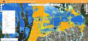
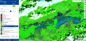
Damage assessment product delivered within the EMSN194 activation as accessible on the Copernicus EMS viewer. Credit: European Union, Copernicus Emergency Management Service, 2024.
Unfortunately, a second bout of heavy rains in the region caused a new flood in mid-June 2025. The Jacuí River burst its banks, leaving highly populated areas such as Cachoeira do Sul underwater.
Using the Global Flood Monitoring (GFM) tool, it was possible to visualise the extent of the flooded areas. In fact, data on flood extent, land use, and affected population can be downloaded directly from the GFM portal. Moreover, the flood delineation data provided by GFM are integrated into the GloFAS portal, enabling users to access flood information and forecasts in a single platform.
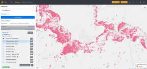
Observed Flood Extent product available via the GFM portal showing the Jacuí River on 23 June 2025. Credit: European Union, Copernicus Emergency Management Service, 2025.
GloFAS has also been key to flood forecasting in the face of extreme events such as Hurricane Iota. In November 2020, several Central American countries prepared for the arrival of one of the most intense hurricanes in recorded history, Category 5 Hurricane Iota.
As the hurricane approached the coasts of Nicaragua and Honduras, GloFAS provided floodplain forecasts, outlining the estimated flood extent of major rivers.
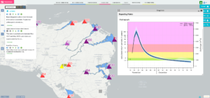
Forecast information available via the GloFAS viewer during Hurricane Iota crisis on 18 November 2020. Credit: European Union, Copernicus Emergency Management Service, 2025.
In the days following Hurricane Iota’s landfall, data from the Copernicus Sentinel-1 and Copernicus Sentinel-2 satellites showed the flood-affected areas, with rivers overflowing their banks along the Northern coast of Nicaragua and Honduras.
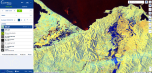
Flooded areas along Motagua River, Guatemala, and Ulúa River, Honduras. Credit: European Union, Copernicus Sentinel-1 imagery, 19 November 2020.
Flooded areas along Motagua River, Guatemala, and Ulúa River, Honduras. Credit: European Union, Copernicus Sentinel-2 imagery, 25 November 2020.
The Role of the CopernicusLAC Panama Centre
The CopernicusLAC Panama Centre serves as a hub for national authorities, emergency responders, and local stakeholders seeking to harness free and open Copernicus data to support disaster risk reduction and tackle the effects of climate change in our region.
In particular, the Centre is directly addressing flood risks through its Hydrometeorological Hazards Services. This set of services, which is co-developed and tailored to local needs, focuses on delivering geospatial products leveraging the free and open data provided by the Copernicus Sentinel satellites to assess hydrometeorological risks, including floods, storms, and extreme rainfall events.
Products of this service dedicated to flood include the Flood Extent Mapping, which provides an estimation of the cumulative extent of flood traces using Copernicus Sentinel-1 imagery over a defined period around the event start date.
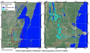
Copernicus Sentinel 1-derived flood extent maps for Belize (data acquired on 3 November 2022). Credit: CopernicusLAC Centre
When combined with elevation data such as a Digital Elevation Model (DEM) map, these flood extent maps enable the delivery of the Flood Depth Mapping (FLDM) product, which delivers high-resolution maps of maximum water depth per pixel.
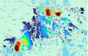
Water depth maps analysis for a flood event in Colombia. Data derived from the flood extent maps and integrating them with a DEM. Credit: CopernicusLAC Centre
The Centre EO Services are meant to deliver key insights for national institutions, emergency responders, and development agencies, improving early warning systems, risk planning, and post-event recovery efforts.
Moreover, capacity building is further supported through the Centre’s Digital Campus, where courses on the use of satellite data applied to disasters such as floods are available. Relevant courses already available cover:
- “Remote sensing applied to flood monitoring”
- “Hydromet hazards”
- “Remote sensing applied to disaster risks”
These courses are designed to equip participants with theoretical and practical skills, applying Earth Observation data to real disaster risk reduction scenarios. Beyond building technical expertise, they foster a holistic understanding of the socio-economic and environmental dimensions that are essential for effective flood management and preparedness.
📝 Register to the digital campus here:
Conclusions
Floods pose an increasing threat to lives, infrastructure, and ecosystems across the LAC region. By combining the powerful capabilities of the Copernicus Sentinel satellites with operational services such as CEMS, Copernicus delivers timely and reliable data for flood forecasting, emergency response, monitoring, and recovery. From mapping inundated areas to forecasting river overflows and assessing population exposure, these tools enable national authorities and humanitarian actors to make evidence-based decisions.
Through the CopernicusLAC Panama Centre, this global capacity is translated into local action, empowering local authorities to harness the free and open Copernicus data for disaster risk reduction. Training initiatives, community events, and the co-development of tailored Earth Observation services are meant to further strengthen local capacities, helping communities across Latin America and the Caribbean build resilience against disasters and climate change challenges.
Background Information
The activities of the Centre fall within the overall context of the EU-LAC Digital Alliance, which is a strategic framework to promote cooperation between the European Union (EU) and the Latin America and Caribbean (LAC) region on digital and space issues under the umbrella of the EU Global Gateway strategy. In this context, the European Space Agency (ESA) coordinates the implementation of the Centre on the basis of a Contribution Agreement with the Directorate General for International Partnerships (DG INTPA) of the European Commission, and in close collaboration with the Government of Panama, the MIRE (Ministry of Foreign Affairs), the AIG (Government Innovation Authority), and the SENACYT (National Secretariat for Science, Technology and Innovation).