


To speak of La Mojana is to speak of water. This vast alluvial plain in Colombia, where the Magdalena, Cauca, and San Jorge rivers converge, has historically been a landscape shaped by flooding. Its marshes, streams, and slow-moving waterways are not an anomaly, but part of its natural dynamics.
This situation presents considerable challenges for effective risk management. Colombia is regularly affected by flooding events, resulting in recurrent emergencies and an urgent need to analyse flood occurrence, severity, patterns, and frequency. A comprehensive understanding of these factors is critical for informed decision-making across different time horizons.
A recent event clearly demonstrated this. On 27 August 2025, the breach of a levee in the Cara de Gato area, in San Jacinto del Cauca (Bolívar), caused widespread flooding in La Mojana. The damage extended to several municipalities, affecting communities, productive systems and livelihoods, and serving as a stark reminder of this region’s vulnerability to hydrological hazards.
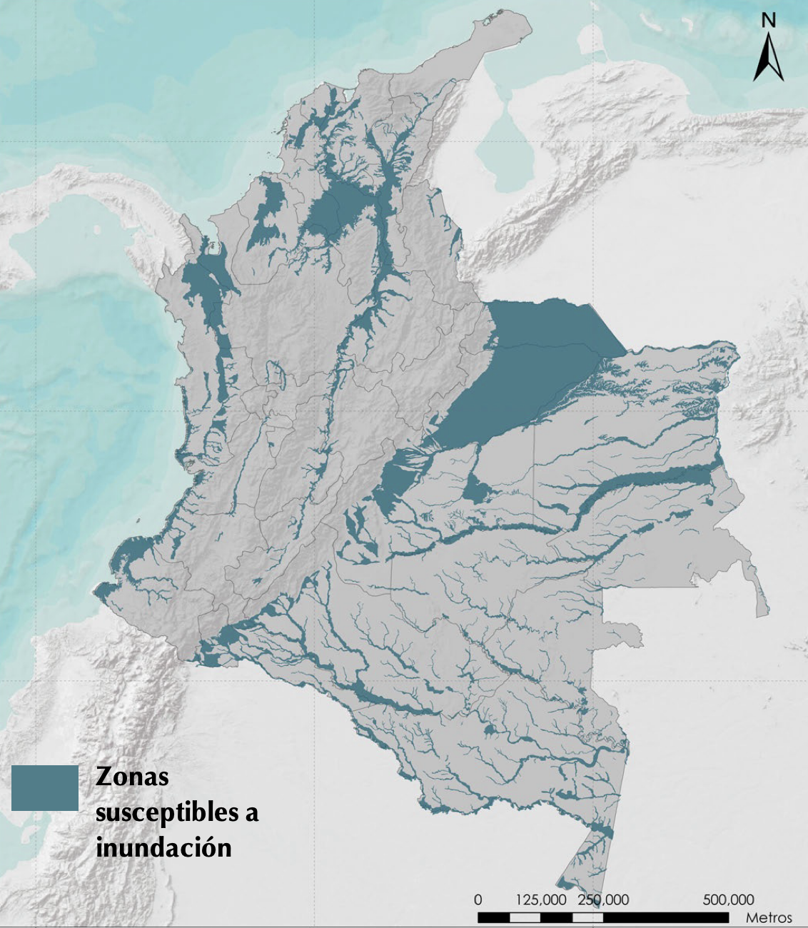
Figure 1. Map of flood-prone areas in Colombia. Source: Colombia Risk Atlas: Revealing Latent Disasters, UNGRD 2019
From reaction to anticipation
In this context, Earth Observation data has opened a new way of understanding risk. Through the services co-developed with the CopernicusLAC Panama Centre, Colombia’s National Unit for Disaster Risk Management (UNGRD) has strengthened its analytical capacity, shifting from a reactive approach to a more proactive one.
These services turn large volumes of satellite data into actionable insights, providing ongoing evidence to identify trends, forecast conditions, and improve decision-making beyond the simple monitoring of flooding events.
Thanks to these services, it is possible to distinguish between permanent water bodies and temporarily flooded areas, estimate the extent of flooding episodes, approximate water depth and analyse the frequency with which these phenomena recur across the territory. This set of capabilities has changed the way risk is interpreted in complex regions such as La Mojana.
Furthermore, the historical flood catalogue (2015–2025) developed complements the monitoring capability and enables identification of recurrence patterns and facilitates comparison of event magnitudes over time. Information derived from EO data serves as a key input for evidence-based decision-making in risk management. In fact, these resources allow for estimation of flood depth and the conduct of preliminary impact assessments by integrating flooded areas with digital elevation models and geospatial data concerning the exposure of population, crops, and livestock.
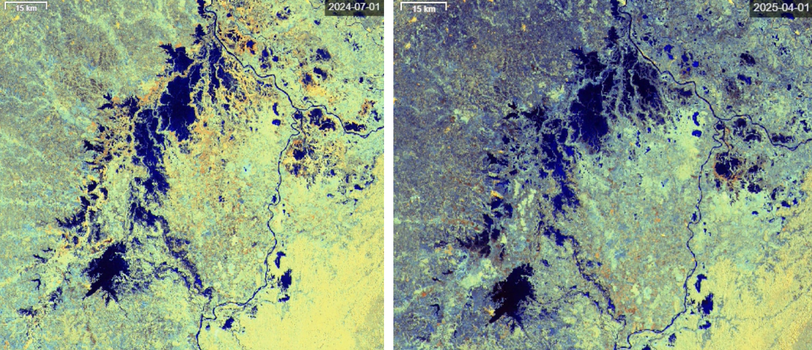
Figure 2. La Mojana region, Colombia in 2024 (left) and 2025 (right). These Copernicus Sentinel-1 satellite images show water in dark blue, urban areas in yellow, vegetated areas in turquoise and bare or sparsely vegetated surfaces in dark purple. Source: European Union, Copernicus Sentinel-1 imagery.
Three services to understand the territory
Three services have been developed as part of the CopernicusLAC Panama Centre activities within Use Case 2, which focuses on flood frequency and impact mapping. These combine data from the Copernicus Sentinel-1 and Sentinel-2 satellite missions with cloud-based processing.
- The Flood Extent Mapping service enables the precise delineation of flooded areas.
- The Flood Frequency Service builds on flood extent mapping by generating a statistical record of how often each location has been flooded.
- The Flood Depth Service estimates water depth using flood extent mapping and a Digital Elevation Model.
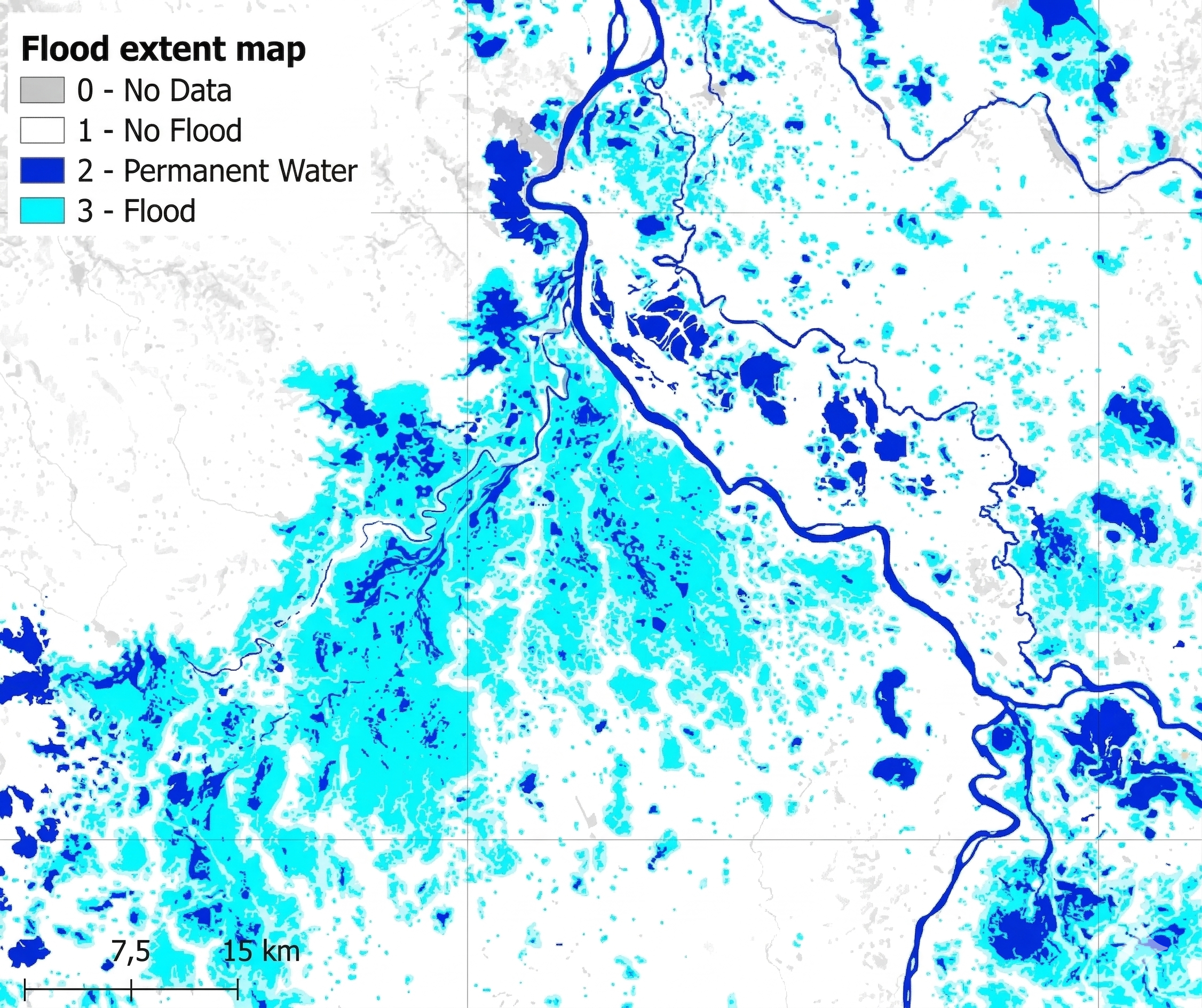
Figure 3. Flood Extent Mapping Service applied to La Mojana region, Colombia in August 2025.
They not only generate information but also provide a comprehensive overview of flood dynamics. The Flood Extent Mapping service has been fully automated: every time a new satellite image is ingested, the system processes it immediately and publishes a new flood-extent map in the user’s workspace, hosted on the CopernicusLAC Panama Centre platform – available to authorised entities.
This process allows the production of flood maps with an automatic update capability, which is crucial during emergencies. This immediacy has significantly reduced analysis times, enabling institutions to obtain an initial estimate of the event’s scale within a few hours of the images being acquired.
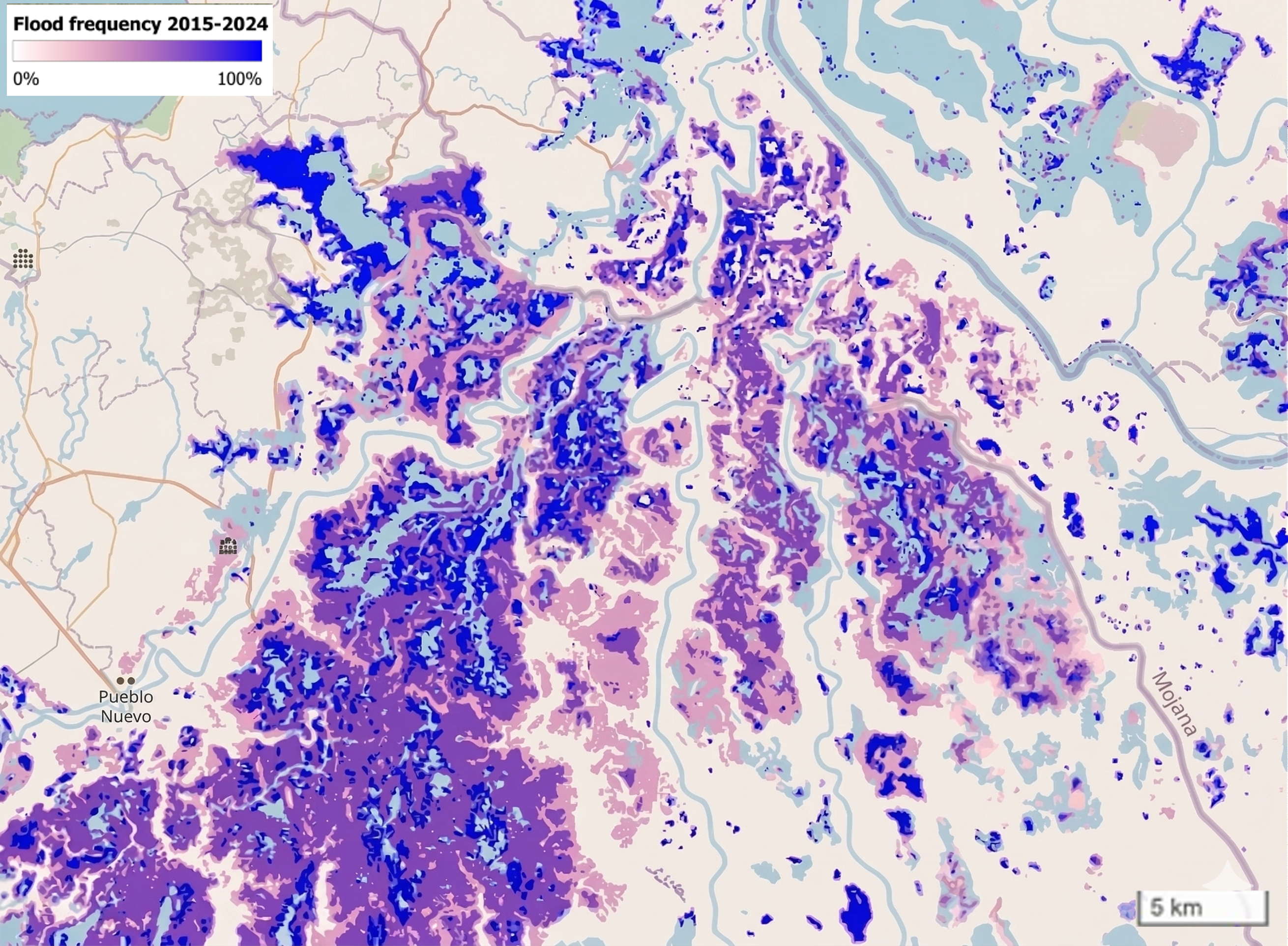
Figure 4. Flood Frequency Map for the La Mojana Region, Colombia.
The Flood Frequency Service builds on Flood Extent Mapping by generating a statistical record of how often each location has been flooded, automatically analysing all available satellite imagery to calculate flood frequency per pixel. By analysing over a decade of Copernicus Sentinel satellite data, this service has shown that many of the affected areas are not the result of exceptional events, but of recurring patterns. These new services, co-developed by the CopernicusLAC Panama Centre, have been instrumental in informing spatial planning, land use and long-term development strategies through the use of objective evidence.
Additionally, the Flood Depth Mapping Service estimates water depth using Flood Extent Maps and a Digital Elevation Model, turning flood maps into tools for assessing potential damage. It runs on demand and helps evaluate the impact on people, infrastructure, and crops.
From data to institutional action
One of the greatest contributions of these services has been their effective integration into institutional processes. At the UNGRD, information derived from EO data is incorporated into geographic information systems and cross-referenced with data on population, infrastructure, crops and livestock, as well as with field reports. This integration has enabled a shift from fragmented analyses to more comprehensive assessments of the territory, strengthening the monitoring of hydrometeorological hazards, the evaluation of impacts and the prioritisation of planning and response actions.
The impact of this approach has been amplified by collaboration between the UNGRD, the Institute of Hydrology, Meteorology and Environmental Studies (IDEAM) and the National Adaptation Fund (FAN). The active participation of these entities in the design, validation and use of the services has ensured that the tools meet real needs and can be used in operational contexts.
A significant milestone was the deployment of these services during the flooding event in the department of Córdoba, Colombia, in which the CopernicusLAC Panama Centre’s services were used to support emergency response activities. This case demonstrated that timely access to reliable information can make a substantial difference to decision-making during a crisis.
What factors have been key to its viability and potential replicability?
According to the UNGRD, there are three key factors:
- This methodology relies on open data, automated workflows, and standardised criteria, enabling its use in other areas susceptible to flooding, such as Arauca or the Orinoquía region.
- Consistent satellite coverage makes it easier to compare different regions and produce reliable national analyses.
- Incorporating these products into institutional geographic information systems means results can be added to current analysis methods without needing new tools for every location.
The CopernicusLAC Panama Centre and its contribution to disaster risk reduction in Latin America and the Caribbean
The experience in La Mojana represents a concrete example of the impact of CopernicusLAC Panama Centre EO services for disaster risk reduction in Latin America and the Caribbean (these services fall under the EU’s Global Gateway strategy). In a region highly exposed to hydrometeorological hazards, having tools which enable the anticipation, monitoring, and analysis of events represents a strategic advantage.
These EO services contribute to risk reduction by strengthening three key aspects: improving risk awareness by providing detailed information on the occurrence, frequency, and intensity of events; strengthening emergency response by providing timely inputs to support decision-making; supporting long-term planning by generating evidence which can be incorporated into land-use planning and sustainable development.
In this regard, the CopernicusLAC Panama Centre not only provides technology but also promotes a shift in the way risk is managed: a transition towards more preventive, data-driven models which are coordinated across institutions.
Background Information
The activities of the CopernicusLAC Panama Centre fall within the overall context of the EU-LAC Digital Alliance, which is a strategic framework to promote cooperation between the European Union (EU) and the Latin America and Caribbean (LAC) region on digital and space issues under the umbrella of the EU Global Gateway strategy. In this context, the European Space Agency (ESA) coordinates the implementation of the Centre on the basis of a Contribution Agreement with the Directorate General for International Partnerships (DG INTPA) of the European Commission, and in close collaboration with the Government of Panama, the MIRE (Ministry of Foreign Affairs) and the SENACYT (National Secretariat for Science, Technology and Innovation).