


Date: 19 September 2020
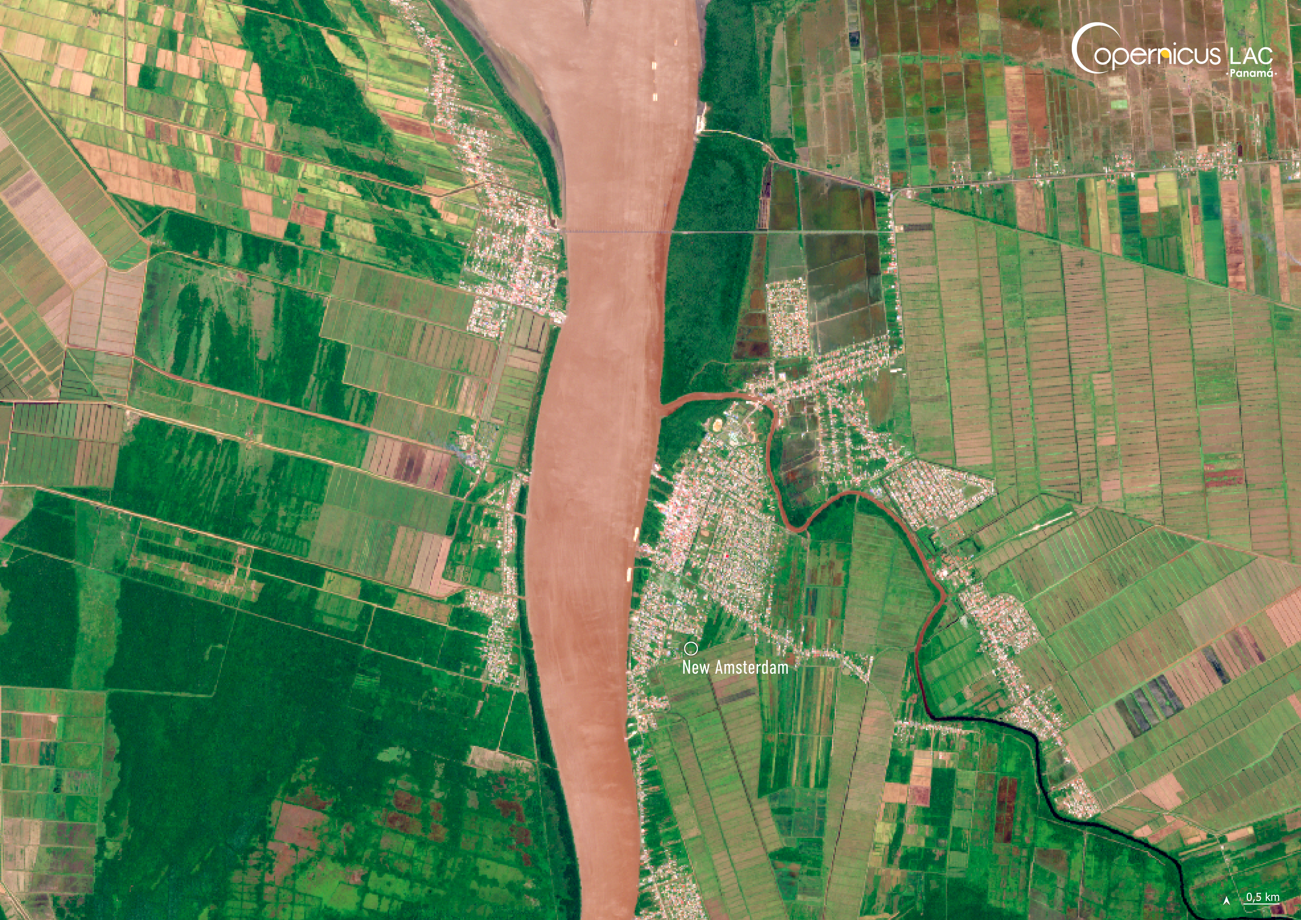
Location: New Amsterdam, Guyana
Credit: Copernicus Sentinel-2 image, processed by the CopernicusLAC Panama Centre
Description:
This Copernicus Sentinel-2 image, acquired on 19 September 2020, shows New Amsterdam, Guyana.
Guyana faces a range of climate-related threats, with flooding being the most challenging. Approximately 90% of the country’s population resides in areas situated below sea level. In addition, the deterioration and disappearance of mangrove forests have worsened coastal flooding and allowed saltwater to encroach onto agricultural lands. This saltwater intrusion not only threatens crop production but also poses a risk to the country’s freshwater resources.
This risk is compounded by the fact that sea levels in Guyana are rising at a rate exceeding the global average of 2 to 4 mm, further intensifying the threat to lives, infrastructure, and the national economy.
In this context, the CopernicusLAC Panama Centre is co-developing tailored Earth Observation Services to address these risks, leveraging the free and open data provided by the Copernicus Sentinel satellites. These includes services related to flood frequency and impact mapping and delineation mapping of past flooding events. These services aim to support stakeholders across the LAC region, including in Guyana, in responding to and preparing for future events.
To stay updated on the latest activities from our Centre, be sure to follow us on LinkedIn, Instagram and X.
Background Information
The Copernicus LAC Panama Centre’s activities take place within the overall context of the EU-LAC Digital Alliance, which is a strategic framework for promoting cooperation between the EU and the LAC region on digital and space issues under the EU Global Gateway umbrella. Within this context, the European Space Agency (ESA) is coordinating the Centre’s implementation on the basis of a Contribution Agreement with the Directorate-General for International Partnerships (DG INTPA) of the European Commission, and in close collaboration with Panama’s government, MIRE (Ministry of Foreign Affairs), Government Innovation Authority (AIG), and SENACYT (National Secretariat for Science, Technology and Innovation).
The CopernicusLAC Panama Centre will serve as a hub for innovation in the Latin America and Caribbean region, supporting national and local entities in leveraging Copernicus data and information to boost socio-economic benefits and resilience. In addition to providing engagement opportunities, the Centre is developing geospatial Disaster Risk Reduction (DRR) Earth Observation (EO) Services (addressing hydrometeorological hazards, wildfires, geological hazards, and hazard exposure) in close collaboration with local users and stakeholders, to whom they will be handed over to ensure that the unique needs of the region are addressed in the long term.
In addition, knowledge and skills transfer is a key element of the CopernicusLAC Panama Centre, which hosts a Digital Campus with access to training modules and educational resources for technical users and citizens alike. The Centre will also organise community-building events, policy dialogues and industry matchmaking, as well as hackathons and other EO data challenges to stimulate user adoption of Copernicus data and innovation. These events will also foster cross-collaboration among EO, disaster risk reduction (DRR) and other relevant ecosystems.
Finally, the Centre will support the development of a high-power computing and data storage cloud infrastructure for the LAC region. One of the final objectives of the Centre is to promote the development of communities of practice and to strengthen the knowledge and use of tools for DRR and other application areas in the public sector, academia, the private sector, and social organisations.