


Date: 27 January 2025
Location: Castries, Saint Lucia
Credit: Copernicus Sentinel-2 image, processed by the CopernicusLAC Panama Centre
Description:
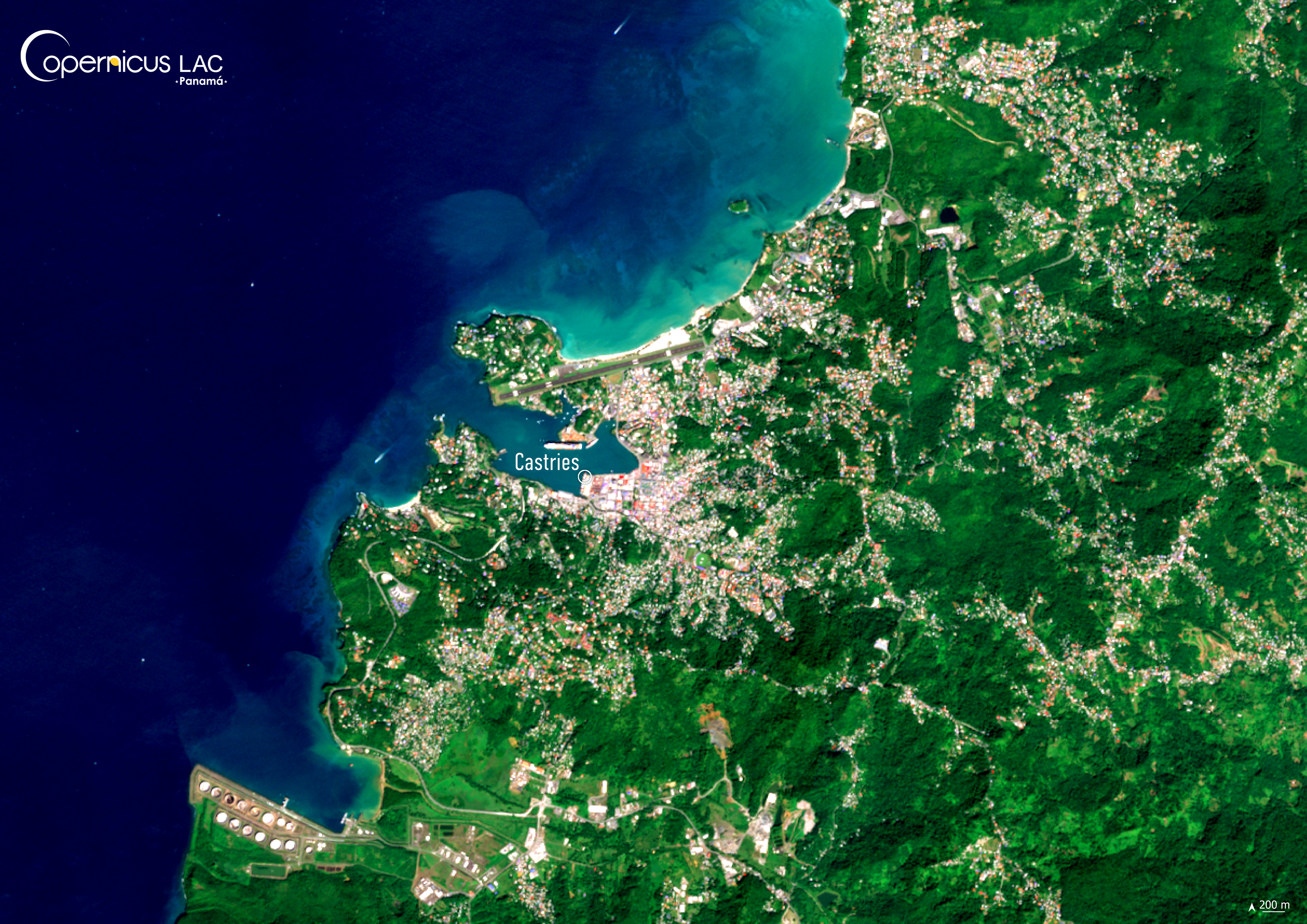
This Copernicus Sentinel-2 image shows Castries, the capital of Saint Lucia, as captured on 27 January 2025.
Saint Lucia, a volcanic island of just 616 km² – around the same size as Santiago’s urban area in Chile – which is highly vulnerable to climate-related hazards. Situated in the Atlantic hurricane belt, the island is regularly exposed to tropical cyclones and associated floods, particularly during the hurricane season from June to November.
Rapid urban expansion around the capital Castries, combined with ecosystem degradation, is intensifying the island’s risks to these hazards.
Timely and reliable Earth Observation (EO) data is key for monitoring storms and its impacts. In this context, the CopernicusLAC Panama Centre supports local authorities and emergency responders of Saint Lucia and the Caribbean in leveraging the free and open Copernicus EO data to support disaster preparedness. In close collaboration with local stakeholders, the Centre is also co-developing tailored EO Services, such as the Geohazards Service, which focuses on detecting and monitoring a wide range of ground motion phenomena, and the Hydrometeorological Service, which provides key information on drought and floods leveraging Copernicus Sentinel data.
In addition, the Centre works to increase the uptake of Copernicus data in the LAC region through trainings and educational resources on Copernicus data for disaster risk reduction (DRR). Materials from past training courses are made available for free to all registered users of the CopernicusLAC Panama Centre Digital Campus, which offers not only introductions to the fundamentals of remote sensing but also applied training including:
- Remote sensing applied to flood monitoring
- Hydrometeorological hazards
- Remote sensing applied to disaster risks
To stay updated on the latest activities from our Centre, be sure to follow us on LinkedIn, Instagram and X.
Background Information
The Copernicus LAC Panama Centre’s activities take place within the overall context of the EU-LAC Digital Alliance, which is a strategic framework for promoting cooperation between the EU and the LAC region on digital and space issues under the EU Global Gateway umbrella. Within this context, the European Space Agency (ESA) is coordinating the Centre’s implementation on the basis of a Contribution Agreement with the Directorate-General for International Partnerships (DG INTPA) of the European Commission, and in close collaboration with Panama’s government, MIRE (Ministry of Foreign Affairs), Government Innovation Authority (AIG), and SENACYT (National Secretariat for Science, Technology and Innovation).
The CopernicusLAC Panama Centre will serve as a hub for innovation in the Latin America and Caribbean region, supporting national and local entities in leveraging Copernicus data and information to boost socio-economic benefits and resilience. In addition to providing engagement opportunities, the Centre is developing geospatial Disaster Risk Reduction (DRR) Earth Observation (EO) Services (addressing hydrometeorological hazards, wildfires, geological hazards, and hazard exposure) in close collaboration with local users and stakeholders, to whom they will be handed over to ensure that the unique needs of the region are addressed in the long term.
In addition, knowledge and skills transfer is a key element of the CopernicusLAC Panama Centre, which hosts a Digital Campus with access to training modules and educational resources for technical users and citizens alike. The Centre will also organise community-building events, policy dialogues and industry matchmaking, as well as hackathons and other EO data challenges to stimulate user adoption of Copernicus data and innovation. These events will also foster cross-collaboration among EO, disaster risk reduction (DRR) and other relevant ecosystems.
Finally, the Centre will support the development of a high-power computing and data storage cloud infrastructure for the LAC region. One of the final objectives of the Centre is to promote the development of communities of practice and to strengthen the knowledge and use of tools for DRR and other application areas in the public sector, academia, the private sector, and social organisations.