


The Exposure Mapping section provides three Earth Observation services to accurately map urban characteristics and economic assets. The output layers when overlaid with vulnerability and hazard data can support all kind of disaster risk and impact assessment. In addition, proprietary layers are made available in the platform for usage in one of the services and direct exploitation from the end user.
Population Distribution
The Population Distribution service provides high‑resolution estimates of population distribution and density by redistributing aggregated population counts using detailed information on the built environment. The service leverages the World Settlement Footprint (WSF) layers, WSF Tracker, WSF Imperviousness, and WSF 3D (building‑height data), to capture settlement extent, surface sealing and vertical structure.
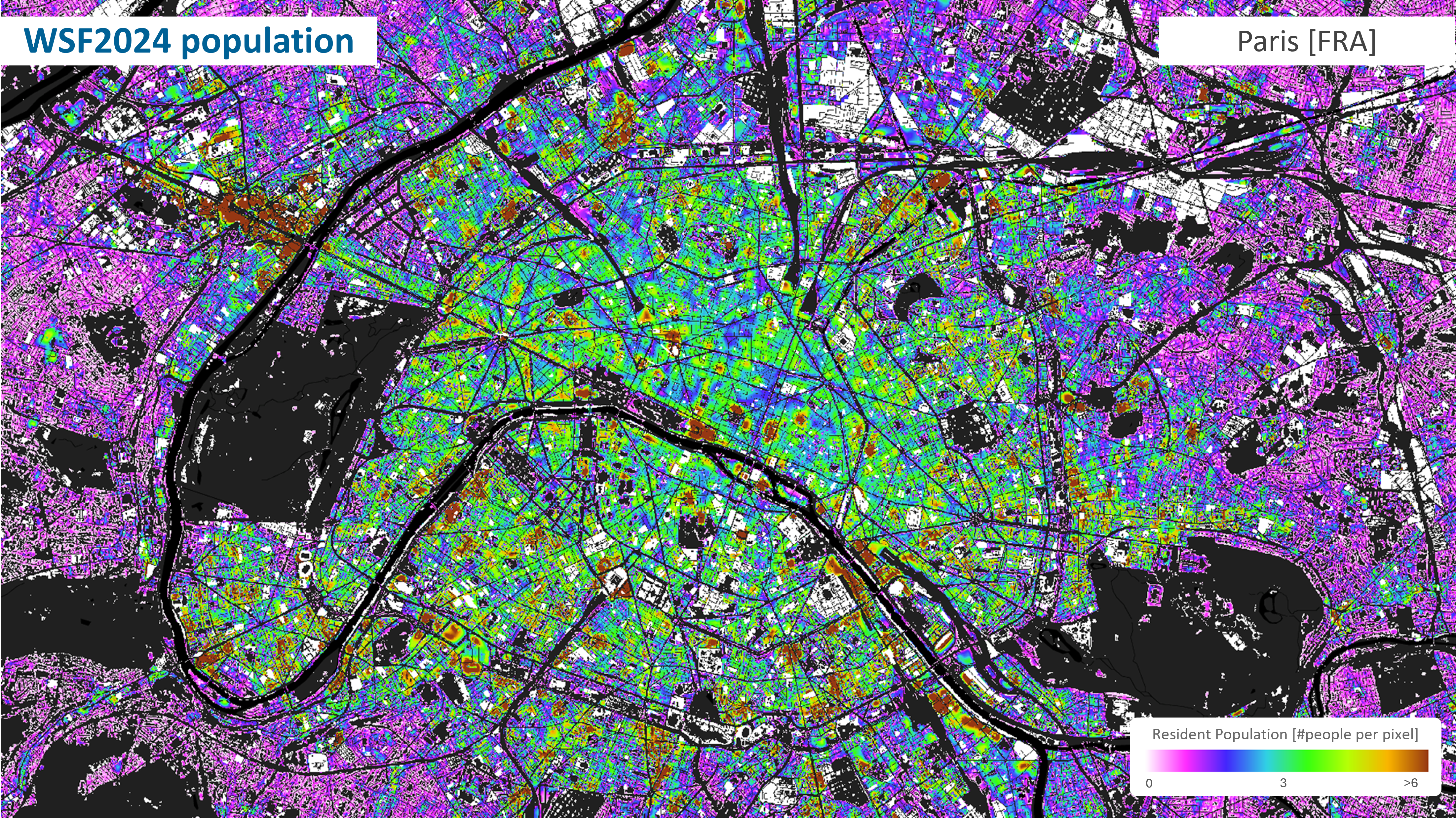
Example of population distribution results over Paris (France). Credits: DLR
The service, developed by DLR and Indra, spatially disaggregates population figures supplied at administrative‑unit level into fine‑scale population maps using a geospatial redistribution approach informed by settlement characteristics. Users may provide their own reference population totals for the selected area, such as census or official statistical data, which are then redistributed across the urban fabric based on the relative weight of the WSF input layers.
By combining built‑up extent, impervious surfaces and building height, the service accounts for both horizontal and vertical settlement patterns, producing population estimates at up to 10‑metre spatial resolution. Population layers can be generated on demand for a user‑defined Area of Interest and updated as new WSF datasets or population inputs become available.
The outputs support urban and territorial planning, disaster-risk management and emergency preparedness, exposure and impact assessment and allocation of resources, and include:
- A raster population‑distribution map (persons per pixel), and
- Where applicable, vector‑based population estimates at building level.
Economic Value Mapping
The Economic Value Mapping (EVM) service provides estimates of the economic value of exposed physical assets within a user‑defined area of interest. The service translates aggregated economic information into georeferenced value layers, enabling quantitative assessment of exposure and potential impacts when combined with hazard and vulnerability data.
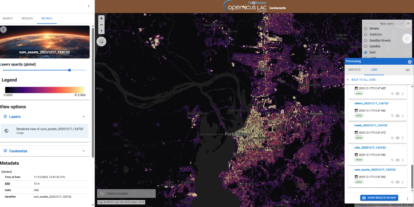
Example of economic valuation map over Porto Alegre (Brazil) – sum of all assets layer – in USD/m2, displayed in the CopernicusLAC platform.
The service, developed by Indra, estimates the economic value of built and productive assets, such as residential and industrial buildings, transport infrastructure, agricultural production systems and other man‑made elements. It relies on open geospatial layers describing land use, settlements and infrastructure, together with official statistics and economic datasets from reliable sources.
Users execute the service on demand by selecting an Area of Interest (AOI) and defining the economic reference values to be used. They may either rely on the default national‑level economic totals provided by the service, supply their own national aggregated asset values, or directly introduce aggregated asset values for the selected AOI when such local information is available. These reference values are then spatially disaggregated across the AOI using land‑use and asset‑distribution information.
The valuation approach is designed to be flexible and adaptable across different national contexts, ensuring that local economic knowledge can be incorporated without requiring detailed asset‑by‑asset inventories.
Outputs consist of raster layers representing the spatial distribution of economic value, expressed in USD/m2, and suitable for direct integration with hazard, susceptibility and vulnerability maps. The products are provided per asset category (e.g. agriculture stock, industrial buildings and equipment, roads, rails, household contents…) and as a summation of all assets analysed.
The products support disaster-risk and impact assessment, post-event damage estimation and recovery planning, prioritisation of mitigation and protection measures and strategic planning and resource allocation.
Ecosystem Services Value Mapping
The Ecosystem Services Value Mapping (ESVM) service provides spatially explicit estimates of the economic value of key ecosystem services within a user‑defined area of interest. The service quantifies and maps ecosystem contributions that are relevant for disaster‑risk management, land‑use planning and environmental decision‑making, complementing physical‑asset exposure analyses.
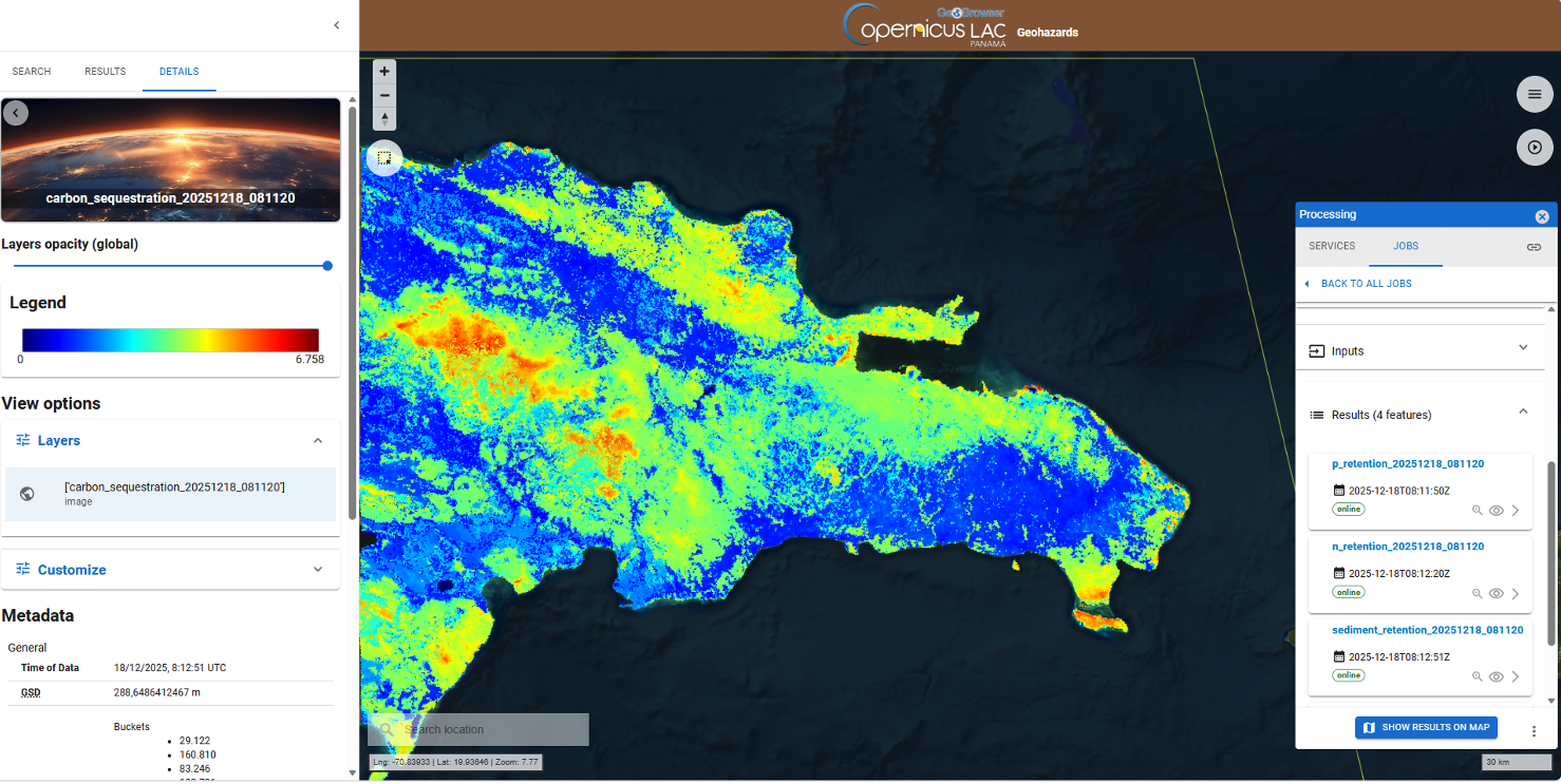
Example of carbon storage valuation over the Dominican Republic, displayed in the CopernicusLAC platform.
The service, developed by Indra, estimates the economic value of selected regulating ecosystem services, including:
- Carbon storage,
- Nutrient retention, and
- Sediment retention.
It builds on established InVEST‑based modelling approaches, combining open geospatial datasets describing land cover, terrain and hydrological characteristics with economic valuation parameters derived from recognised sources. These datasets are integrated to produce spatial representations of ecosystem service provision and their associated economic value.
The service is executed on demand, with users selecting an Area of Interest (AOI). Default valuation parameters are provided at the national level, ensuring applicability even in data‑scarce contexts. Where local information is available, users may customise valuation parameters by introducing their own aggregated economic values, allowing the results to better reflect national or regional conditions.
The outputs consist of raster layers representing the spatial distribution of ecosystem service values, expressed in monetary terms. These layers are delivered as GIS‑ready products and can be directly combined with hazard, vulnerability and exposure datasets.
The service supports disaster-risk and impact assessment, by accounting for the economic role of natural systems, evaluation of nature-based solutions and ecosystem-based adaptation, land-use and environmental planning and prioritisation of protection and mitigation measures.