


The wildfires theme will focus on leveraging Copernicus Sentinel data for wildfire assessment and preparedness in the LAC region.
Services will provide insights on burned area, fire danger, and fire recovery mapping, among other topics. The corresponding use cases will be tailored according to the specific needs of the geographic area of application.
The project portfolio includes pre-operational applications, or use cases, of the developed services in selected areas throughout the LAC region for the purpose of demonstrating and testing their capabilities and potential.
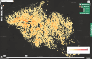
Burned Area Mapping
Service for near-real-time monitoring of active wildfires. This service relies on thermal anomalies acquired from the Copernicus Sentinel-3 Sea and Land Surface Temperature Radiometer (SLSTR) to automatically delineate burned areas on high-resolution Copernicus Sentinel-2 Multi-Spectral Instrument (MSI) tiles. Products include hotspot, burned area extent, probability, and severity maps.
...
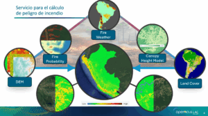
Fire Danger Mapping
Service to estimate the Fire Danger Index per pixel of Copernicus Sentinel-2 imagery based on variables derived from Copernicus, the Global Wildfire Information System (GWIS) Fire Weather Index, and other EO sources.
...
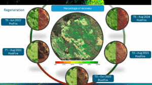
Fire Recovery Mapping
Service designed to monitor and evaluate the recovery of vegetation in areas affected by wildfires. It generates user-defined temporal Normalised Difference Vegetation Index (NDVI) composites over detected burned areas and compares them to pre-wildfire conditions to determine the degree of vegetation recovery (in percentage).
...
Burned Area Severity (BAS)
BAS is an on-demand open-source service which computes the severity of fire-affected areas using Copernicus Sentinel-2 imagery.
...
Coherence and Intensity Composite (SAR-COIN)
SAR-COIN is a change detection tool using Copernicus Sentinel-1 SLC data pairs.
...
Filter and Vectorize (FilterVectorize)
FilterVectorize simplifies raster classification outputs by removing noise and converting them to polygons.
...
NDVI Change Detection (NDVI-CD)
NDVI-CD assesses vegetation loss by comparing pre- and post-event optical imagery.
...
Co-located Stacking (STACK)
The STACK service creates a multi-temporal stack of single-band raster datasets co-located on a common spatial grid.
...