


The Latin America and the Caribbean (LAC) region is among the world’s most disaster-prone areas. According to the Regional Assessment Report on Disaster Risk in Latin America and the Caribbean by UNDRR, more than 190 million people were affected by over 1,500 disasters between 2000 and 2022. These events generated an estimated annual loss of USD 58 billion, limiting the capacity of communities and governments to recover and strengthen resilience to future hazards. As climate change increases the frequency and intensity of extreme weather events, the challenges faced by the region continue to grow.
More than 80% of the population of Latin America and the Caribbean live in urban areas, and this proportion is expected to rise. As cities expand, more people and essential services are concentrated in areas exposed to hazards such as floods, landslides, storms, and earthquakes. At the same time, many urban centres in the region have inadequate infrastructure, as well as an increasingly vulnerable population. Together, this results in high levels of exposure.
Understanding who and what is at risk is therefore crucial. Accurate exposure mapping supports not only post-disaster damage assessments but also anticipatory action, long-term planning, and more resilient development pathways. By identifying the assets, populations, and systems which are most exposed, decision-makers can better target investments, design effective preparedness strategies, and reduce the overall impact of disasters across the region.
The Value of Earth Observation for Exposure Analysis
Exposure mapping refers to the process of identifying and locating communities, infrastructure, and economic assets which may be affected by a hazard. It helps determine not only where risks are concentrated but also what is likely to be impacted when an event occurs. Accurate exposure mapping is essential for effective disaster risk management: supporting emergency services in identifying priority areas, guiding long-term planning decisions, and strengthening the ability of governments to prepare for, respond to, and recover from disasters.
Traditional ground-based assessments provide important insights but are often resource-intensive and difficult to update regularly. Earth Observation (EO) satellite data overcomes these limitations by enabling consistent, large-scale, and cost-effective monitoring of land use, settlement growth, and environmental conditions. EO data helps governments and institutions detect changes over time, identify emerging hotspots, and assess exposure with far greater precision. These insights support decision-making across the entire disaster management cycle.
Within the global EO landscape, the European Union’s Earth Observation programme Copernicus provides open access high-quality data . To further promote the uptake of Copernicus data and services, the CopernicusLAC Panama Centre has been setup in the framework of the EU-LAC Digital Alliance and the EU Global Gateway strategy, supporting stakeholders across the LAC region with capacity building activities and tailored co-developed services with local partner institutions. By making advanced geospatial information more accessible and easier to integrate into policy and planning, the CopernicusLAC Panama Centre contributes directly to strengthening the region’s capacity to anticipate and reduce the impacts of disasters.
Monitoring Exposure and Population with Copernicus Data
Copernicus provides extensive EO data through its Sentinel and contributing missions, delivering consistent information about our planet. Sentinel-1 radar imagery detects built-up areas and infrastructure regardless of weather or daylight, while Sentinel-2 optical imagery provides detailed information on land cover and land use. Together, they provide a comprehensive understanding of the spatial patterns and temporal evolution of human settlements.
In addition to satellite observations, Copernicus Services integrate multiple data sources to generate thematic products relevant to a wide range of applications. The Copernicus Emergency Management Service (CEMS) is particularly important in the context of exposure mapping. Within CEMS, the Global Human Settlement Layer (GHSL), covering periods from 1975 to 2030 (projected), provides comprehensive datasets of built-up areas, population density, and human settlements. These combine Copernicus Sentinel-1 imagery with national census information, delivering insight into where people live, how cities expand, and how urbanisation patterns evolve. Such information is essential for identifying populations most exposed to natural hazards and for informing planning and policy development.
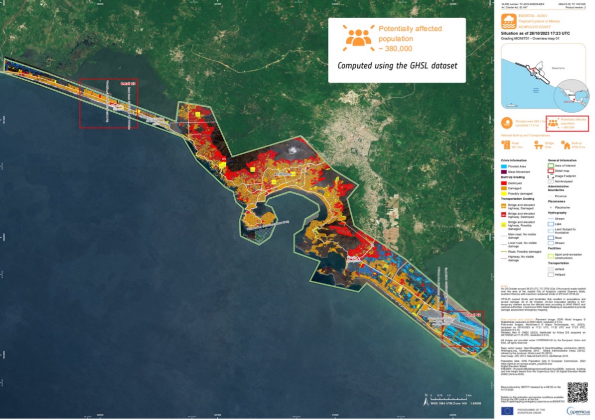
Image showing the CEMS grading map damage grade assessment of the Acapulco coast, Mexico, following Huracán Otis on 25 October 2023. The image includes the potentially affected population, which is computed using GHSL datasets. Credit: European Union, Copernicus Emergency Management Service
The European Commission’s Joint Research Centre (JRC) supports the development of these tools including The Atlas of the Human Planet. Each edition combines settlement maps, population trends, and risk data to highlight how communities grow and where challenges or opportunities arise. Published regularly since 2016, by using GHSL as the backbone of its product, it supports policymakers, researchers, and investors.
The Role of The CopernicusLAC Panama Centre
The CopernicusLAC Panama Centre plays an important role in promoting the uptake of Copernicus free and open EO data and tools also through capacity-building activities, as well as in co-developing tailored services with local partner institutions across the LAC region.
To advance this mission, the Centre is co-developing two services within the exposure theme. These include:
- Economic Value Mapping (EVM) service: which provides estimates of the economic value of assets distributed throughout the LAC region.
- Population Density (PD) service: which produces high-resolution estimates of population density across the region.
The EVM service integrates geospatial, economic, and demographic data to generate classified raster maps in which each pixel represents the estimated value of physical assets such as buildings and infrastructure. When combined with hazard and vulnerability information, these layers support impact assessment, risk estimation, and recovery planning.
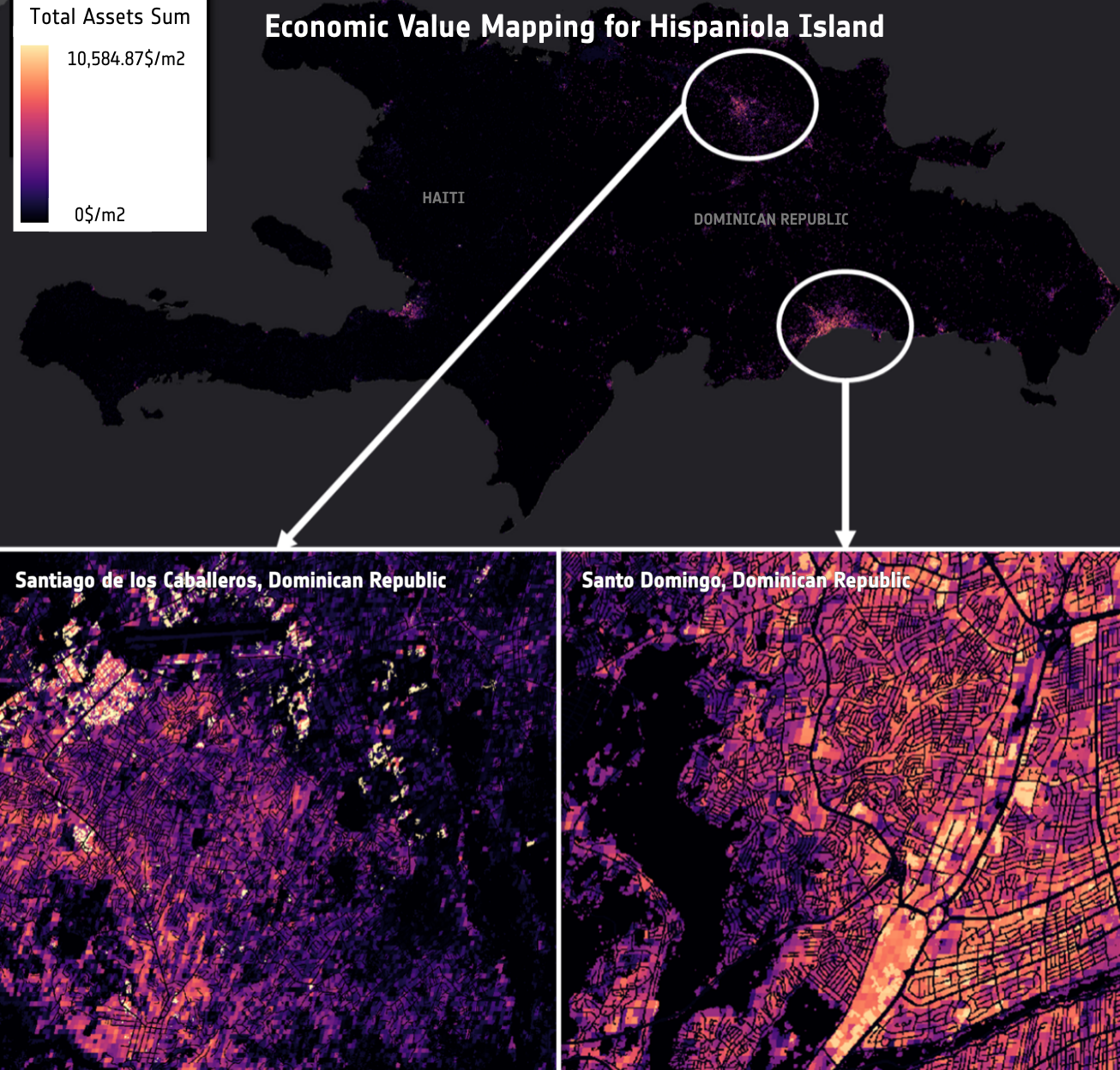
Economic Value map showing assets in USD/pixel for Hispaniola Island, encompassing Haiti and the Dominican Republic. Credit: CopernicusLAC Panama
The Population Distribution (PD) service uses DLR’s World Settlement Footprint (WSF) to produce high-resolution estimates of resident population density at a 10 m spatial resolution, provided in raster and vector formats. It draws on the WSF suite, specifically WSF Tracker, WSF Imperviousness, and WSF 3D, to redistribute population figures within built-up areas according to structural characteristics. The WSF Evolution product provides regular six-monthly updates, enabling users to capture rapid urban expansion and analyse changes in near real time.
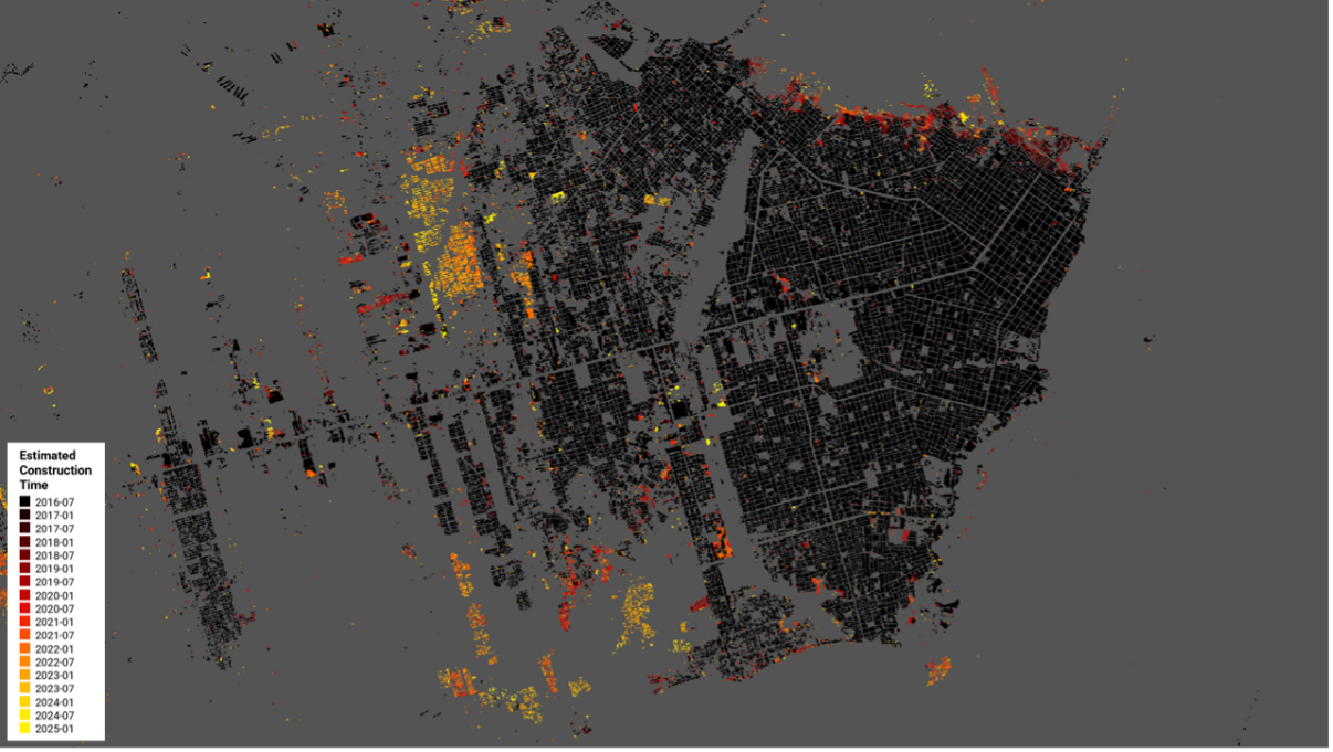
WSF Tracker outlining the 6-month settlement extent growth at 10 m spatial resolution from July 2016 to January 2025, Pucallpa, Peru. Credit: CopernicusLAC Panama
The WSF Imperviousness layer calculates the percent impervious surface (PIS) which is widely used as a proxy for building density and plays a key role in improving population distribution in urban models. An impervious surface is one that does not allow water to infiltrate, such as a paved road or concrete. This layer is key for assessing urban flood risk and characterising the urban heat-island effect. For a more detailed view of the built environment, the WSF 3D dataset provides global estimates of the vertical dimension of built-up areas at 10-metre resolution, combining open-access elevation models with artificial intelligence-derived information.
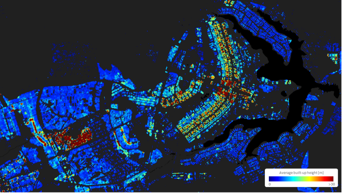
WSF 3D estimating building height at 10 m spatial resolution for Brasília, Brazil. Credit: CopernicusLAC Panama
Conclusion
As disasters in Latin America and the Caribbean become more frequent and severe, strengthening resilience requires not only understanding exposure but also integrating EO data into the operational workflow. Copernicus Sentinel satellite missions and services provide consistent and reliable data, enabling authorities to identify communities, infrastructure, and economic assets at risk. The CopernicusLAC Panama Centre supports stakeholders in translating these insights into actionable planning, preparedness, and recovery measures, providing tailored tools as well as capacity-building opportunities through online, on-site, and MOOC training via the Digital Campus. By promoting the uptake of its EO services, The CopernicusLAC Panama Centre helps build safer, more resilient communities across the region.
Background Information
The activities of the CopernicusLAC Panama Centre fall within the overall context of the EU-LAC Digital Alliance, which is a strategic framework to promote cooperation between the European Union (EU) and the Latin America and Caribbean (LAC) region on digital and space issues under the umbrella of the EU Global Gateway strategy. In this context, the European Space Agency (ESA) coordinates the implementation of the Centre on the basis of a Contribution Agreement with the Directorate General for International Partnerships (DG INTPA) of the European Commission, and in close collaboration with the Government of Panama, the MIRE (Ministry of Foreign Affairs) and the SENACYT (National Secretariat for Science, Technology and Innovation).