





Following the recent Copernicus-supported earthquake responses in Venezuela and Colombia, a major seismic event in Panama has again demonstrated the importance of rapid and actionable Earth Observation information across Latin America and the Caribbean. The response also brings this regional challenge directly to the host country of the CopernicusLAC Panama Centre, where satellite-based emergency mapping and ground-motion analysis are supporting both immediate situational awareness and longer-term resilience planning.
The powerful magnitude 7.7 earthquake that struck central Panama on 9 October 2026 (17:56 UTC / 12:56 local time) in Los Santos province, made emergency managers and geospatial experts mobilize Earth Observation (EO) tools to map infrastructure damage, identify active displacement zones, and support field operations.
Through coordination among national authorities—including the Government Innovation Agency (AIG)—the Copernicus Emergency Management Service (CEMS), the International Charter: Space and Major Disasters, the CopernicusLAC Panama Centre and the ECHO Regional Office in Panama, satellite-based workflows are providing rapid situational awareness and detailed measurements of ground displacement across the affected provinces.
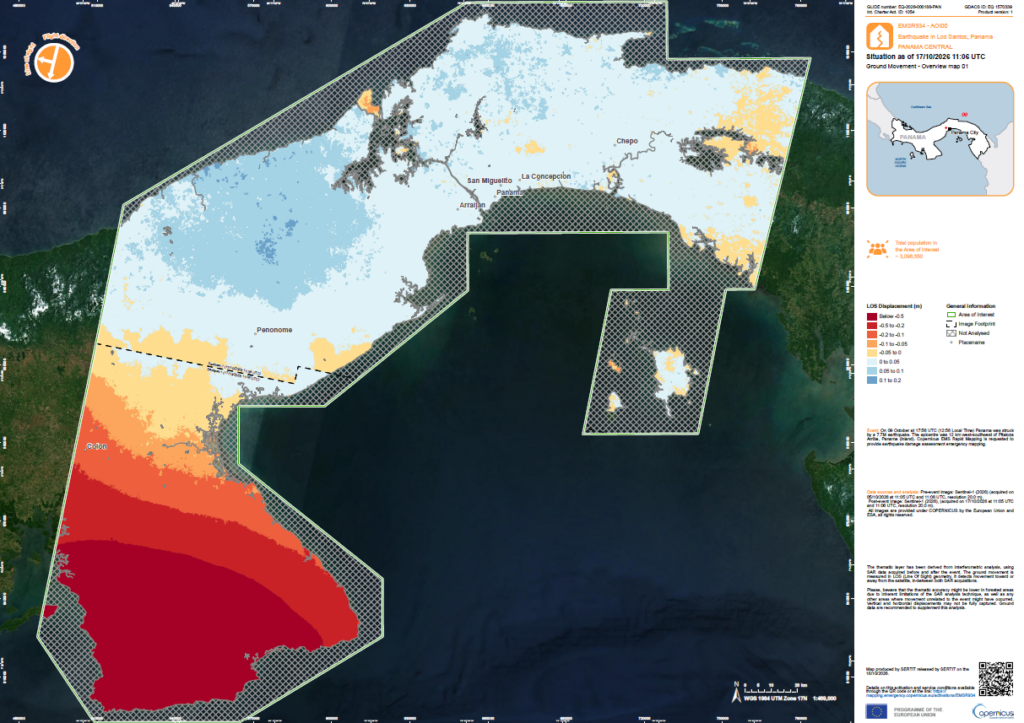
The Impact Footprint & Affected Areas
The inland rupture occurred at an estimated focal depth of 12.6 km. Strong ground motion impacted the Azuero Peninsula and central Panama, heavily affecting the provinces of Herrera, Los Santos, Coclé, and Veraguas, with severe shaking felt across Panama City.
Infrastructure Impact: Structural damage to residential and public buildings, localized road cuts, and impacts reported across 29 healthcare facilities spanning eight provinces and the Ngäbe-Buglé Indigenous Region. A national state of emergency was declared on 10 October to facilitate coordinated relief (Source: Disasters Charter).
Immediately following the event, the Copernicus Emergency Management Service (CEMS) was triggered under activation EMSR934, establishing 9 Areas of Interest (AOIs). Contributing commercial missions were tasked to acquire Very High-Resolution (VHR) optical data over prioritized settlements and infrastructure corridors. The International Charter was also activated (activation ID 1054)
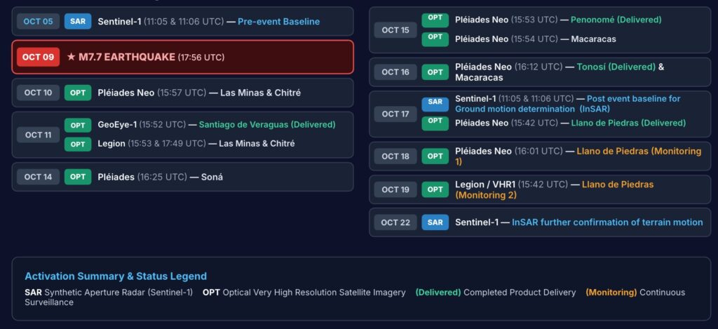
Regional InSAR Ground Movement Analysis
In parallel with optical damage grading, radar interferometry (InSAR) provides an expansive view of surface deformation. Copernicus Sentinel-1 radar imagery acquired pre-event (05/10/2026, 11:05 UTC) was paired with post-event acquisitions on 17/10/2026 (11:05 UTC) across the affected area.
The resulting overview map provides a detailed quantification of Line of Sight (LOS) surface displacement. Please note that this map and the final report can still change with further revisions of the processing.
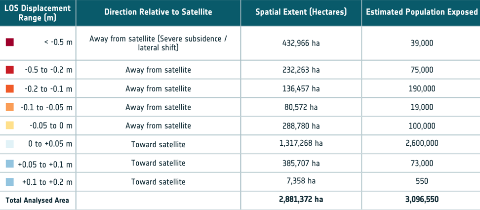
The analysis identifies approximately 432,966 hectares with line-of-sight displacement greater than 0.5 m away from the satellite, intersecting areas with an estimated population of 39,000. Because a single InSAR viewing geometry measures displacement only along the sensor’s line of sight, additional analysis is required to separate vertical and horizontal motion and to determine the underlying geophysical or geotechnical causes. This analysis suggest the amount of people exposed to different levels of terrain deformation.
How are the products of the Copernicus Emergency service helping?
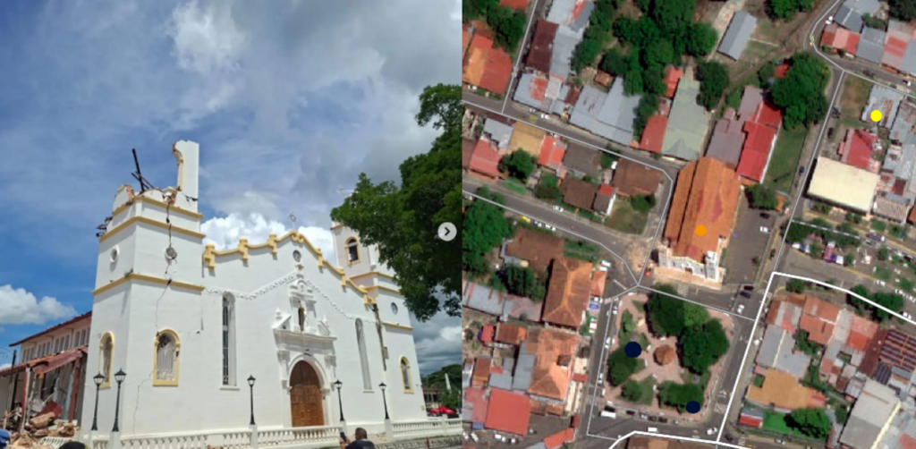
Transitioning from rapid response to long-term resilience
By combining CEMS rapid mapping, very-high-resolution imagery and Sentinel-1 ground-motion analysis, emergency managers can obtain complementary information to help prioritise field verification, infrastructure assessment and recovery planning. Beyond the immediate response, the CopernicusLAC Panama Centre can support the integration of these products into longer-term hazard and resilience workflows. Continued monitoring, combined with field observations and national datasets, can help authorities better understand post-seismic ground movement, slope instability and other secondary hazards.
The satellite response is continuing, and further mapping products may become available as new imagery is acquired and processed.
Follow the latest developments and access newly delivered products through the CEMS EMSR934 reporting page.