


Among the activities of the CopernicusLAC Panama Centre is the development of the Financial Value Mapping pilot service, which will provide Latin America and the Caribbean (LAC) with a robust tool for estimating the economic value of territories. It will provide users with on-demand land use maps segmented into distinct assets; each assigned a corresponding economic evaluation expressed in USD/m². The pilot service will enable improved territorial planning by providing decision-makers with detailed and actionable insights for optimising land use and resource allocation. Furthermore, it will support disaster risk reduction by providing precise economic valuations to inform more effective preparedness strategies and post-disaster assessments.
Demonstration in the Dominican Republic
To showcase its capabilities, the initiative will be initially demonstrated in the Dominican Republic. A pre-operational application covering the entire country will be developed using data from local stakeholders and participants, including detailed economic activity values and other relevant information. This collaborative approach will ensure the production of a high-resolution map with the most accurate and specific economic valuations possible.
As a consequence of its geographical location, the Dominican Republic is significantly exposed to extreme weather phenomena. This vulnerability results in frequent and severe damages and losses. The products derived from the Financial Value Mapping pilot service will provide full coverage of the country, showcasing the project’s ability to deliver high-resolution economic valuation maps tailored to the unique characteristics of the Dominican Republic and at a later stage, the LAC region more broadly.
The initiative is developed in partnership with the Dominican Republic’s Directorate for Disaster Risk Management and Climate Change of the Ministry of Economy, Planning and Development (MEPYD), which provides essential expertise and guidance throughout the development and demonstration phases of the initiative. Their support helps ensure that the pilot service aligns with regional needs and best practices.
Integration with the CopernicusLAC Panama Centre
The Financial Value Mapping pilot service is designed to be integrated seamlessly with the other CopernicusLAC Panama Centre pilot services. For instance, the economic valuation maps derived can be cross-referenced with various risk and impact maps produced by other of Centre’s pilot services. This integration will improve the precision of both real and potential economic loss estimations, ultimately supporting more informed decision-making.
An example of this integration can be seen with Use Case 11 (urban characterisation) , in which the Financial Value Mapping service will be informed by the urban exposure products, further improving its results.
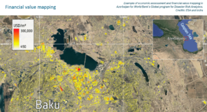
Example of economic assessment and financial value mapping of Baku, Azerbaijan. Credit: ESA and Indra
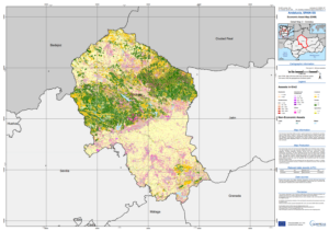
Example of economic assessment and financial value mapping in Andalucia, Spain. Credit: Indra
Background Information
The Copernicus LAC Panama Centre’s activities take place within the overall context of the EU-LAC Digital Alliance, which is a strategic framework for promoting cooperation between the EU and the LAC region on digital and space issues under the EU Global Gateway umbrella. Within this context, the European Space Agency (ESA) is coordinating the Centre’s implementation on the basis of a Contribution Agreement with the Directorate-General for International Partnerships (DG INTPA) of the European Commission, and in close collaboration with Panama’s government, MIRE (Ministry of Foreign Affairs), Government Innovation Authority (AIG), and SENACYT (National Secretariat for Science, Technology and Innovation).