


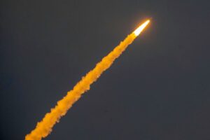
The Launch of Sentinel-1C
The Copernicus Sentinel-1C satellite successfully launched from Europe’s spaceport in Kourou, French Guiana, on 5 December 2024. As the only radar satellite mission delivering data on free and fully open basis, the Copernicus Sentinel-1 mission plays an essential role in support of a wide range of sectors worldwide, including emergency management, as well as land and maritime monitoring.
Sentinel-1C has joined the Sentinel-1A satellite in orbit as a replacement for the retired Sentinel-1B, and will support the mission’s legacy in continuing to deliver important Synthetic Aperture Radar (SAR) data to users around the world. What does this launch mean for the CopernicusLAC Panama Centre and its users in Latin America and the Caribbean (LAC)?
 Credit: ESA–M. Pédoussaut
Applications of Copernicus Sentinel-1 in the LAC region
The Copernicus Sentinel-1 mission has numerous applications on land and at sea. Thanks to the addition of Sentinel-1C, the nominal temporal resolution will allow for land changes to be monitored more closely, informing decisions related to urban planning, agriculture, and forest management. The mission enables the Differential Synthetic Aperture Radar Interferometry technique for the monitoring of the smallest ground movements, helping to better understand earthquakes, landslides, volcanic activity, and other ground deformation events, as illustrated by this image of Haiti after the 2021 earthquake.
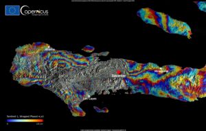
On 14 August 2021, a 7.2 magnitude earthquake struck Haiti, generating massive ground deformations, which can be quantified using this interferogram created using Copernicus Sentinel-1 data from 3 and 15 August 2021. Credit: European Union, Copernicus Sentinel-1 data
The Copernicus Sentinel-1 mission has also applications at sea. In the case of maritime transportation, using radar to detect ships, including fishing boats and vessels, helps to make waters in the LAC region safer. In fact, Sentinel-1 radar imagery also supports oceanographic studies by providing data on wind and wave conditions. This is particularly useful for weather forecasting, optimising the fuel consumption of ships, developing marine renewable energy power generation installations, and understanding ocean circulation patterns. The radar’s ability to observe ocean surface features helps to create accurate models of wave heights and wind speeds. It is also able to detect accidental or voluntary oil spills.
Finally, by providing SAR data, the Copernicus Sentinel-1 mission is key to supporting disaster risk reduction in the LAC region. SAR-equipped satellites acquire data in all weather conditions and at night, enabling the delivery of mapping products for hazard monitoring and supporting emergency response activities.
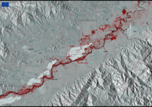
On 15 November 2024, Tropical Storm Sara brought severe flooding to Honduras. This image acquired by Copernicus Sentinel-1A shows flooded areas around the Aguán River near the city of Tocoa. Credit: European Union, Copernicus Sentinel-1 data
Promoting the uptake of Copernicus Sentinel-1 data in the LAC region
By providing free trainings and online courses on how to leverage Sentinel-1 data, the CopernicusLAC Panama Centre plays a key role in fostering user uptake in the LAC region.
The Centre is also co-developing with users from the region a portfolio of pilot services which will be made available by the CopernicusLAC centre in Panama. These services are based on Copernicus data and have a primary focus on disaster risk reduction and resilience. Many of these services leverage data from the Sentinel-1 missions, and will enhance DRR capabilities in the region and support communities, boosting their resilience to climate change-induced extreme weather events.
Background Information
The Copernicus LAC Panama Centre’s activities take place within the overall context of the EU-LAC Digital Alliance, which is a strategic framework for promoting cooperation between the EU and the LAC region on digital and space issues under the EU Global Gateway umbrella. Within this context, the European Space Agency (ESA) is coordinating the Centre’s implementation on the basis of a Contribution Agreement with the Directorate-General for International Partnerships (DG INTPA) of the European Commission, and in close collaboration with Panama’s government, MIRE (Ministry of Foreign Affairs), Government Innovation Authority (AIG), and SENACYT (National Secretariat for Science, Technology and Innovation).