


Throughout 2023 and 2024, multiple countries in Latin America have faced one of the longest droughts in recent decades. The impacts of this drought range from water scarcity, which affects food security, to a lack of energy production from hydroelectric plants as a consequence of significantly reduced river flows. Countries such as Bolivia and Brazil have been seriously affected by drought and rising temperatures since 2023. Ecuador is in the midst of an energy crisis due to the inability to generate hydroelectric power, while some cities, such as Bogotá, Colombia, have implemented a water rationing system to cope with the drought.
This crisis has been exacerbated by the El Niño and La Niña phenomena as well as other factors such as deforestation, over-exploitation of water resources, and soil erosion. In addition to water scarcity, high temperatures and arid conditions have contributed to one of the most severe wildfire crises in decades for Bolivia, Brazil, and Ecuador, with record emissions and worsening air quality for nearby communities.
By exploring the role of Copernicus in monitoring drought in the Latin American and Caribbean (LAC) region in 2023 and 2024, this article introduces how Copernicus open data and services support LAC countries during these crises while informing early warning strategies to mitigate impacts on agriculture, biodiversity, and society at large.
The Copernicus Sentinel Satellites and Copernicus Services
Copernicus is the Earth observation (EO) component of the European Union’s Space Programme. It provides free and openly accessible information services that draw from satellite and in situ (non-space) data.
The Copernicus Sentinel satellites play an important role in monitoring global droughts by identifying key related elements, such as vegetation and bodies of water, through their instruments. For instance, the Copernicus Sentinel-2 mission is equipped with a multispectral instrument (MSI) which extracts information about the Earth’s surface using 13 spectral bands. Band 8 of the satellites operates in the near-infrared spectrum, enabling the accurate identification of vegetation and serving as a basis for the composition of indices such as the Normalised Difference Vegetation Index (NDVI).
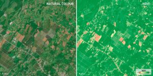
Example of identifying crop and vegetation areas with Copernicus Sentinel-2 data. Left: Natural colour composition showing various agricultural plots in the vicinity of Siquirres, Costa Rica. Right: NDVI index using visible red and near-infrared (NIR) spectral bands. Credit: European Union, Copernicus Sentinel-2, 4 February 2024.
Additionally, thanks to their high temporal resolution, the Sentinel-2 satellites are able to acquire images of a given area of the Earth’s surface every five days, enabling reliable and consistent monitoring of fluctuations in the levels of water bodies. Other satellite missions, including Copernicus Sentinel-1, use radar technology, which allows them to monitor water bodies at night or under cloudy conditions.
Since drought conditions contribute to the spread of fires around the world, fire monitoring is essential to managing areas affected by drought. The European Space Agency’s Sentinel-3 Global Wildfire Atlas enables the identification of wildfire hotspots in near real-time by using data from the Sea and Land Surface Temperature Radiometer (SLSTR) instrument of the Copernicus Sentinel-3A satellite. This information is openly available to users and policymakers managing the impacts of disasters.
Global Wildfire Atlas Viewer
Open data from the Copernicus services are instrumental in providing useful information on the state of droughts in the LAC region. An example is the Copernicus Emergency Management Service (CEMS), which provides geospatial data and information to support disaster management. Thanks to data provided by its Early Warning and Monitoring component, CEMS helps to identify large-scale phenomena such as droughts.
The CEMS Drought Component, composed of the European Drought Observatory (EDO) and the Global Drought Observatory (GDO), provides continuous information on drought conditions, forecasts, and early warnings. As visible in the image below, the Standardised Precipitation Index (SPI) of the GDO enabled the monitoring of the emergence of a meteorological drought in various parts of Brazil between April and October 2023. This index tracks deviations in precipitation over a given period of time in comparison to the average.
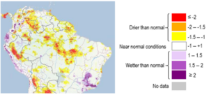
Standardised Precipitation Index SPI-6. Credit: European Union, Copernicus Emergency Management Service (CEMS), GDO data.
The Copernicus Land Monitoring Service (CLMS) provides open data with global coverage on the status of vegetation cover, land use, and soil moisture. These datasets are essential for applications in agriculture, water resource management, and meteorological analysis. The data, accessible through the CLMS viewer, helps address environmental challenges such as drought, food security, and biodiversity conservation.
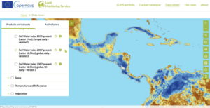
Data from the Soil Water Index (SWI) for 11 October 2024. Dark blue shades identify values above 80%, while brown shades indicate values below 20%. Data provided by the Copernicus Land Monitoring Service viewer.
Critical cases in the LAC Region
By providing information on key parameters related to drought, the Copernicus Sentinel satellites and services are able to support communities and authorities affected by ongoing or future episodes of drought. This free and open data is key to helping LAC countries respond to the effects of these crises on topics such as food security and biodiversity, while creating strategies to foster future resilience.
Recent drought has affected the biodiversity of aquatic ecosystems in the Amazon Basin. In Lake Tefé, approximately 500 km from Manaus, Brazil, over 120 dolphins died in 2023 due to rising water temperatures. In 2024, drought conditions in the lake continued, as evidenced by images acquired by the Copernicus Sentinel-2 satellites. The following false-colour image shows the nearly depleted lake, alongside a notable decrease in the flow of the Solimões River, one of the main tributaries of the Amazon.
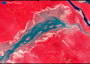
Lake Tefé, Brazil, on 24 September 2024. Credit: European Union, Copernicus Sentinel-2.
The drought risk and persistence forecasts published by the Global Drought Observatory inform decision-makers in creating and implementing policies to manage food or water crises. The Emergency Response Coordination Centre (ERCC) of the Directorate-General for European Civil Protection and Humanitarian Aid Operations (DG ECHO) highlighted the situation in South America using data from the GDO. The following map shows the duration of heatwaves in January 2024, the SPI precipitation anomaly between November 2023 and January 2024, and drought meteorological persistence between February 2023 and January 2024.
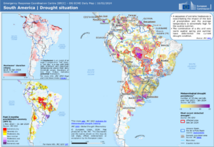
Daily ERCC map from DG ECHO, dated 16 February 2024, showing various indicators provided by the GDO Early Warning and Monitoring component. Credit: European Union, DG ECHO ERCC 2024.
High temperatures and arid conditions in the summer of 2024 led to an increase in the number of fires and related emissions in Bolivia and the Brazilian Amazon. According to the Copernicus Atmosphere Monitoring Service (CAMS), total cumulative emissions in Brazil between January and September were higher than average at around 180 megatonnes of carbon, thus following a similar trajectory as in 2007, a year of record emissions.
Aerosol optical depth (AOD) analyses over South America from August to September 2024. Based on CAMS data.
The Copernicus Sentinel-3 and Sentinel-5P satellites have enabled monitoring of the smoke and atmospheric pollutants produced by fires in the LAC region. The following image shows the smoke plume over the central region of South America, which reached the coast of Africa in the days that followed.
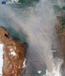
Smoke plume over Argentina, Paraguay, Brazil, and Bolivia on 4 September 2024. Credit: European Union, Copernicus Sentinel-3
The Role of the CopernicusLAC Panama Centre
As climate change leads to an increase in the frequency and intensity of droughts, Copernicus data will play an even more important role in helping public authorities and local communities in the LAC region to prepare for, respond to, and recover from these events and their consequences.
In this context, the CopernicusLAC Panama Centre serves as a hub for communities and individuals interested in harnessing free and open Copernicus data for disaster risk reduction and to address climate change issues.
The CopernicusLAC Panama Centre hosts policy dialogues, private sector support, workshops and community events, while providing trainings and educational resources on EO data, including applications for addressing drought. Furthermore, in October 2024, the Centre hosted its first hackathon, which featured three key challenges which participants addressed by leveraging Copernicus data. Under one of these challenges, dedicated to “Preserving biodiversity and endangered habitats”, some participants focused on using Copernicus data to identify areas vulnerable to drought, as well as ways to improve notification systems for affected communities. In this way, the Centre acts as a focal point for community engagement and the transfer of knowledge and skills related to these topics.
To complement these existing activities and support further local capacity building, the CopernicusLAC Panama Centre will develop three streams of EO-based pilot services. These will be delivered to local stakeholders for continued implementation after the pilot demonstration phase. In addition to a geo-hazards service and an exposure service, the Centre will support the development of a hydrometeorological service which will focus on leveraging Copernicus data to help public authorities strengthen their early warning capabilities in relation to events including drought. This data will support preparedness and prevention activities, thereby increasing resilience to such events.
Finally, in parallel to the activities mentioned above, the Centre’s activities will also include technical assistance and the development of tools for the scoping, design, and installation of a Copernicus Data Centre in Panama, which will ensure privileged access to Copernicus data for users in the region.
The Copernicus LAC Panama Centre’s activities take place within the overall context of the EU-LAC Digital Alliance, which is a strategic framework for promoting cooperation between the EU and the LAC region on digital and space issues under the EU Global Gateway umbrella. Within this context, the European Space Agency (ESA) is coordinating the Centre’s implementation on the basis of a Contribution Agreement with the Directorate-General for International Partnerships (DG INTPA) of the European Commission, and in close collaboration with Panama’s government, MIRE (Ministry of Foreign Affairs), Government Innovation Authority (AIG), and SENACYT (National Secretariat for Science, Technology and Innovation).