


Use Case 4 demonstrates how large‑scale flood hazard information can be produced by merging satellite‑based observations with hydrological model outputs. The approach integrates Sentinel‑1 derived flood maps, including long‑term flood frequency and satellite‑derived flood depth, with GloFAS return‑period and model‑based depth estimates from the Copernicus Emergency Management Service. These two information streams feed the Flood Hazard service, which combines them pixel‑by‑pixel to produce harmonised hazard layers at 90‑m resolution.
To support this, the system generates multi‑year flood frequency maps from the Sentinel‑1 archive across a 1.5‑million‑km² region and ingests these products together with GloFAS outputs to compute the final hazard maps. The result is a consistent set of satellite‑informed, forecast‑aware flood hazard products that provide users with regional‑scale insight into expected flood severity under different return‑period conditions. The use case also includes the demonstration of the service over selected river basins in Colombia and Panama as part of the initial roll‑out.
Areas of application: Central America, Colombia, Peru, Ecuador
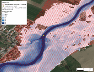
Hazard map developed merging TELEMAC-2D model and adjusted to Earth Observation flood extent. Marche region (Italy), 2023. Legend: Darker shades of blue indicate deeper water. Credits: CIMA foundation