


Las inundaciones son uno de los desastres más frecuentes y afectan a millones de personas cada año. Sus consecuencias van desde la destrucción de cultivos, que compromete la seguridad alimentaria, hasta daños en la infraestructura o la pérdida de vidas humanas.
La deforestación, los incendios forestales y la urbanización son factores que contribuyen al riesgo de inundaciones. Al eliminarse la vegetación, el suelo pierde su capacidad natural para absorber agua, lo que aumenta la escorrentía hacia los ríos y, finalmente, llega a las zonas urbanas. En las ciudades, las superficies impermeables aumentan el riesgo al bloquear la infiltración y, a menudo, sobrecargar los sistemas de drenaje, especialmente a medida que las lluvias torrenciales se vuelven más frecuentes e intensas como consecuencia del cambio climático. Por lo tanto, una planificación urbana eficaz, una infraestructura resiliente y una previsión meteorológica oportuna son esenciales para reducir los impactos y proteger a las comunidades.
En este contexto, existe una necesidad creciente de adoptar estrategias de prevención y mitigación basadas en datos, incluida la gestión de la tierra basada en evidencia y el uso de herramientas de pronóstico para anticipar y responder a los fenómenos meteorológicos extremos de manera más efectiva.
Satélites Sentinel de Copernicus y servicios de Copernicus
Copernicus, el componente de observación de la Tierra (EO) del Programa Espacial de la UE, proporciona datos gratuitos y abiertos desde sus satélites (Sentinels), así como a través de los Servicios Copernicus con alta resolución temporal y espacial en todo el mundo.
Por ejemplo, los datos proporcionados por los satélites Sentinel-2 de Copernicus son clave para el monitoreo de ríos, embalses y ciudades, rastreando estos entornos para evaluar posibles daños por inundaciones y planificar las operaciones de recuperación en las zonas afectadas. Al mismo tiempo, los datos proporcionados por Sentinel-1 de Copernicus permiten identificar masas de agua y observar la magnitud de las inundaciones durante el día, la noche e incluso en condiciones atmosféricas inestables, que pueden coincidir con fenómenos extremos que las desencadenan (como tormentas o huracanes).
Además, los Servicios de Copernicus , que integran datos de satélites, modelos y datos in situ, proporcionan productos relevantes relacionados con la atmósfera, el cambio climático, los océanos y la vigilancia de la tierra, así como para apoyar actividades de gestión de emergencias.
El servicio de referencia para las actividades de preparación, respuesta y recuperación ante inundaciones es el Servicio de Gestión de Emergencias de Copernicus (CEMS), que proporciona información geoespacial clave y oportuna a través de tres componentes:
- Alerta temprana y monitoreo : incluye el Sistema mundial de conocimiento de inundaciones (GloFAS), que proporciona pronósticos hidrológicos probabilísticos globales (días a meses) y el Monitoreo mundial de inundaciones (GFM), que proporciona información sobre la extensión de las inundaciones gracias a un procesamiento automatizado de todas las imágenes de radar entrantes del Sentinel-1 de Copernicus.
- Mapeo a Demanda : Este componente proporciona productos geoespaciales oportunos tras una activación formal . Apoya a las partes interesadas en la gestión de emergencias antes, durante y después de inundaciones. Este servicio ofrece análisis y evaluaciones de riesgos antes y después de inundaciones, además de monitorear la extensión de las inundaciones y proporcionar evaluaciones de daños inmediatamente después.
- Mapeo de Exposición: A través de la Capa Global de Asentamientos Humanos (GHSL), que combina datos satelitales con datos censales, es posible acceder a una amplia gama de conjuntos de datos que ayudan a mapear e identificar poblaciones e infraestructura vulnerables, brindando información crucial para la reducción de riesgos y la planificación a largo plazo.
El uso efectivo de los datos de Copernicus mejora la respuesta inmediata y fortalece la resiliencia de las comunidades afectadas, sirviendo como referencia estratégica para las autoridades nacionales, las agencias humanitarias y los actores interesados en protección civil en todo el mundo, incluida la región de América Latina y el Caribe (ALC).
Casos de uso en la gestión de inundaciones en América Latina y el Caribe
Los fenómenos meteorológicos extremos son cada vez más frecuentes y severos, también en la región de América Latina y el Caribe, que ya es muy vulnerable a huracanes e inundaciones, así como a incendios forestales y sequías prolongadas, lo que a su vez aumenta el riesgo de inundaciones debido a la cobertura terrestre expuesta. Copernicus ha proporcionado datos antes, durante y después de estos fenómenos.
Por ejemplo, 300 mm de lluvia cayeron en las montañas del norte del estado de Rio Grande do Sul, Brasil, el 31 de abril de 2024, lo que provocó la rotura de presas y deslizamientos de tierra, sumergiendo pueblos enteros. Más de 160 personas perdieron la vida cuando las aguas de la inundación se dirigieron hacia el sur, rumbo a la cuenca hidrográfica del Guaíba, donde convergen los arroyos del tercio norte del estado y fluyen directamente cerca del centro de Porto Alegre.
En respuesta, el componente de Mapeo a Demanda del CEMS fue activado por la Dirección General de Protección Civil y Operaciones de Ayuda Humanitaria Europeas (DG ECHO) de la Comisión Europea para monitorear y evaluar el impacto del evento en el estado de Rio Grande do Sul, Brasil.
En el marco de la activación de EMSN194, el equipo de On-Demand Mapping entregó varios productos geoespaciales, entre ellos:
- Mapas de delimitación de inundaciones
- Análisis temporal de eventos de inundaciones
- Análisis detallados de evaluación de daños
- Evaluación de impacto/análisis de exposición para activos y población
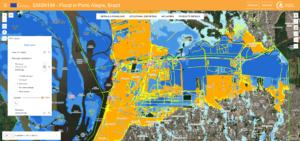
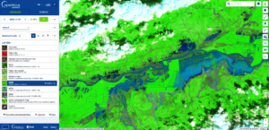
Producto de evaluación de daños entregado con la activación EMSN194, disponible en el visualizador EMS de Copernicus . Crédito: Unión Europea, Servicio de Gestión de Emergencias de Copernicus, 2024.
Desafortunadamente, un segundo episodio de fuertes lluvias en la región provocó una nueva inundación a mediados de junio de 2025. El río Jacuí se desbordó, dejando zonas densamente pobladas como Cachoeira do Sul bajo el agua.
Utilizando la herramienta de Monitoreo Global de Inundaciones (GFM), fue posible visualizar la extensión de las zonas inundadas. De hecho, los datos sobre la extensión de las inundaciones, el uso del suelo y la población afectada pueden descargarse directamente desde el portal GFM . Además, los datos de delimitación de inundaciones proporcionados por GFM están integrados en el portal GloFAS, lo que permite a los usuarios acceder a información y pronósticos de inundaciones en una única plataforma.
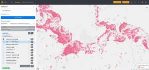
Producto de extensión de inundación observada disponible a través del portal GFM que muestra el río Jacuí el 23 de junio de 2025. Crédito: Unión Europea, Servicio de Gestión de Emergencias Copernicus, 2025.
GloFAS también ha sido clave para la predicción de inundaciones ante eventos extremos como el huracán Iota. En noviembre de 2020, varios países centroamericanos se prepararon para la llegada de uno de los huracanes más intensos de la historia, el huracán Iota de categoría 5.
A medida que el huracán se acercaba a las costas de Nicaragua y Honduras, GloFAS proporcionó pronósticos de llanuras de inundación, describiendo la extensión estimada de las inundaciones de los principales ríos.
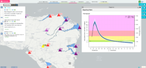
Información de pronóstico disponible a través del visor GloFAS durante la crisis del huracán Iota el 18 de noviembre de 2020. Crédito: Unión Europea, Servicio de Gestión de Emergencias Copernicus, 2025.
En los días posteriores a la llegada del huracán Iota, los datos de los satélites Copernicus Sentinel-1 y Copernicus Sentinel-2 mostraron las zonas afectadas por las inundaciones, con ríos desbordados a lo largo de la costa norte de Nicaragua y Honduras.
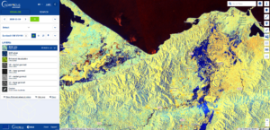
Zonas inundadas a lo largo del río Motagua (Guatemala) y el río Ulúa (Honduras). Crédito: Unión Europea, imágenes de Copernicus Sentinel-1, 19 de noviembre de 2020.
Zonas inundadas a lo largo del río Motagua (Guatemala) y el río Ulúa (Honduras). Crédito: Unión Europea, imágenes de Copernicus Sentinel-2, 25 de noviembre de 2020.
El papel del Centro CopernicusLAC Panamá
El Centro CopernicusLAC Panamá sirve como centro para autoridades nacionales, personal de respuesta a emergencias y partes interesadas locales que buscan aprovechar los datos gratuitos y abiertos de Copernicus para apoyar la reducción del riesgo de desastres y abordar los efectos del cambio climático en nuestra región.
En particular, el Centro aborda directamente los riesgos de inundación a través de sus Servicios de Riesgos Hidrometeorológicos . Este conjunto de servicios, codesarrollado y adaptado a las necesidades locales, se centra en la entrega de productos geoespaciales que aprovechan los datos gratuitos y abiertos proporcionados por los satélites Sentinel de Copernicus para evaluar los riesgos hidrometeorológicos, como inundaciones, tormentas y precipitaciones extremas.
Los productos de este servicio dedicado a las inundaciones incluyen el Mapeo de la Extensión de las Inundaciones , que proporciona una estimación de la extensión acumulada de los rastros de inundaciones utilizando imágenes Copernicus Sentinel-1 durante un período definido alrededor de la fecha de inicio del evento.
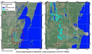
Mapas de extensión de inundaciones de Belice derivados de Copernicus Sentinel 1 (datos adquiridos el 3 de noviembre de 2022). Crédito: Centro CopernicusLAC
Cuando se combinan con datos de elevación, como un mapa del modelo de elevación digital (DEM), estos mapas de extensión de inundaciones permiten la entrega del producto Mapeo de profundidad de inundaciones (FLDM), que ofrece mapas de alta resolución de la profundidad máxima del agua por píxel.
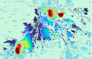
Análisis de mapas de profundidad de agua para una inundación en Colombia. Datos derivados de los mapas de extensión de la inundación e integración con un DEM. Crédito: Centro CopernicusLAC
Los Servicios de EO del Centro tienen como objetivo brindar información clave para instituciones nacionales, personal de respuesta a emergencias y agencias de desarrollo, mejorando los sistemas de alerta temprana, la planificación de riesgos y los esfuerzos de recuperación posteriores a eventos.
Además, el desarrollo de capacidades se apoya a través del Campus Digital del Centro , donde se ofrecen cursos sobre el uso de datos satelitales aplicados a desastres como inundaciones. Los cursos relevantes ya disponibles abarcan:
- “Teledetección aplicada a la monitorización de inundaciones”
- “Riesgos hidrometálicos”
- “Teledetección aplicada a riesgos de desastres”
Estos cursos están diseñados para dotar a los participantes de habilidades teóricas y prácticas, aplicando los datos de Observación de la Tierra a escenarios reales de reducción del riesgo de desastres. Además de desarrollar conocimientos técnicos, fomentan una comprensión integral de las dimensiones socioeconómicas y ambientales esenciales para una gestión y preparación eficaces ante inundaciones.
📝 Regístrate al campus digital aquí::
Conclusiones
Las inundaciones representan una amenaza creciente para la vida, la infraestructura y los ecosistemas en toda la región LAC. Al combinar las potentes capacidades de los satélites Sentinel de Copernicus con servicios operativos como CEMS, Copernicus proporciona datos oportunos y fiables para la previsión de inundaciones, la respuesta a emergencias, el seguimiento y la recuperación. Desde el mapeo de zonas inundadas hasta la previsión de desbordamientos de ríos y la evaluación de la exposición de la población, estas herramientas permiten a las autoridades nacionales y a los actores humanitarios tomar decisiones basadas en la evidencia.
A través del Centro CopernicusLAC Panamá, esta capacidad global se traduce en acción local, empoderando a las autoridades locales para aprovechar los datos gratuitos y abiertos de Copernicus para la reducción del riesgo de desastres. Las iniciativas de capacitación, los eventos comunitarios y el desarrollo conjunto de servicios de observación de la Tierra a medida buscan fortalecer aún más las capacidades locales, ayudando a las comunidades de América Latina y el Caribe a desarrollar resiliencia ante los desastres y los desafíos del cambio climático.
Información de referencia
Las actividades del Centro CopernicusLAC Panamá se desarrollan en el contexto general de la Alianza Digital UE-LAC, que es un marco estratégico para promover la cooperación entre la Unión Europea (UE) y la región de América Latina y el Caribe en cuestiones digitales y espaciales bajo el paraguas de la estrategia Global Gateway de la UE. En este contexto, la Agencia Espacial Europea (ESA) coordina la implementación del Centro sobre la base de un Acuerdo de Contribución con la Dirección General de Asociaciones Internacionales (DG INTPA) de la Comisión Europea, y en estrecha colaboración con el Gobierno de Panamá, el MIRE (Ministerio de Relaciones Exteriores), la Autoridad Gubernamental de Innovación (AIG) y la SENACYT (Secretaría Nacional de Ciencia, Tecnología e Innovación).