


The Copernicus Sentinel satellites’ observations throughout 2025 provided valuable, science-based insights into the Earth’s environment. Over the year, its satellites have captured a range of significant natural phenomena, from snow-covered deserts to unprecedented ocean changes, supplying essential information for understanding global ecosystems. These data and products have played a crucial role in supporting scientific research on climate trends, ecosystem vulnerabilities, and highlighting the importance of Earth Observation (EO) data for monitoring the changing planet.
This article reviews key extreme events which affected the LAC region, as observed through the eyes of Copernicus, and demonstrates how the CopernicusLAC Panama Centre can support via its capacity building and EO Services development activities.
The Eruption of Fuego Volcano, Guatemala
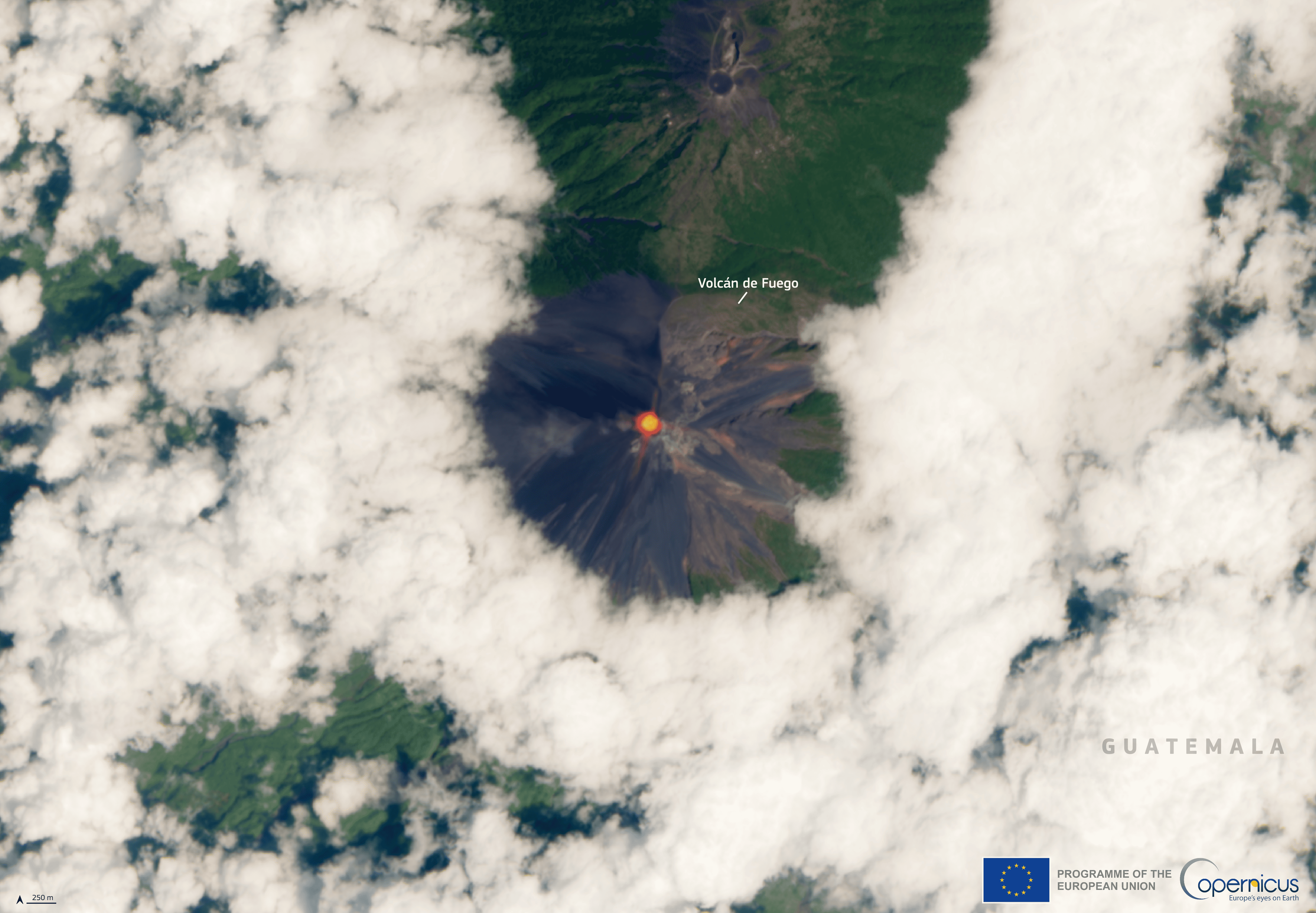
This image, acquired on 9 March 2025 by one of the Copernicus Sentinel-2 satellites, shows the thermal anomaly (infrared signature) detected at the summit of the Fuego Volcano, Guatemala. Credit: European Union, Copernicus Sentinel-2 imagery.
Guatemala’s Fuego Volcano erupted on 9 March 2025, triggering evacuations and heightened monitoring across the region. Copernicus Sentinel-2 imagery acquired on the same day shows a clear thermal anomaly at the summit, with an ash column rising to approximately 6,000 metres and drifting more than 120 kilometres from the crater.
Guatemalan authorities, through the National Coordinator for Disaster Reduction (CONRED), issued an orange alert and evacuated hundreds of people from nearby communities, with up to 30,000 residents advised to prepare for possible evacuation. The Fuego Volcano, located 53 km south-west of Guatemala City, remains one of Central America’s most active volcanoes and a key focus for disaster monitoring agencies.
In this regard, the Centre’s Geological Hazards Theme EO Services under development are helping to monitor similar events. For instance, the Terrain Motion Mapping Interferometric Stacking Service enables users to monitor ground deformation over large areas by processing Copernicus Sentinel-1 SAR data, delivering geocoded outputs, including average displacement rates, at various spatial resolutions. This robust, open-source tool supports reliable assessment of terrain movements and related geological hazards across the LAC region. To delve deeper into the role of EO in managing geohazards, the centre provides a free online course on Remote Sensing Applied to Geohazards, featuring lessons taught by experts in the field.
The Gulf of Panama’s Missing Upwelling
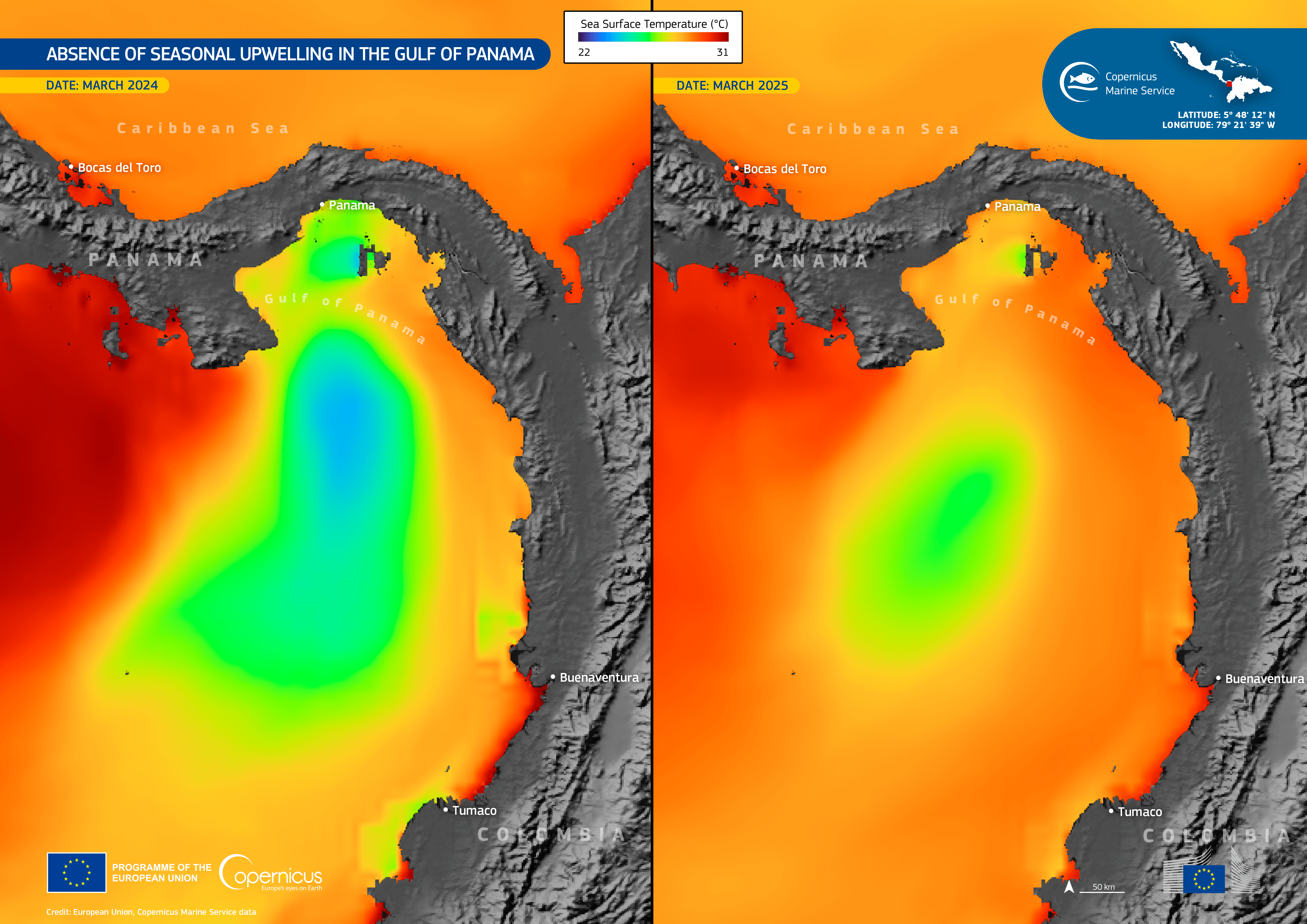
This dataviz, produced leveraging data provided by the Copernicus Marine Service, shows sea surface temperature (SST) in the Gulf of Panama in March 2024 and March 2025. Credit: European Union, Copernicus Marine Service Data
In 2025, the Gulf of Panama did not undergo its usual seasonal upwelling, a process which typically occurs during the dry season from January to April and brings cold, nutrient-rich deep waters to the surface. Scientific analysis attributed the absence of this event to reduced trade-wind activity, which normally drives coastal wind jets and sustains the upwelling. Historically, upwelling begins around 20 January, lasts approximately 66 days, and can cool the waters to 19°C (sometimes as low as 14.9°C). In 2025, the season was unusual: it began 42 days late on 4 March, lasted only 12 days (an 82% reduction) and never cooled below 23.3°C.
As a result, fewer nutrients reached surface waters, while the loss of the cooling effect increased thermal stress on marine ecosystems, including coral reefs. Data from the Copernicus Marine Service revealed markedly higher sea-surface temperatures in March 2025 than in previous years, highlighting a changing marine ecosystem and potential implications for fisheries and coastal communities.
The Wildfire Crisis Across Mexico
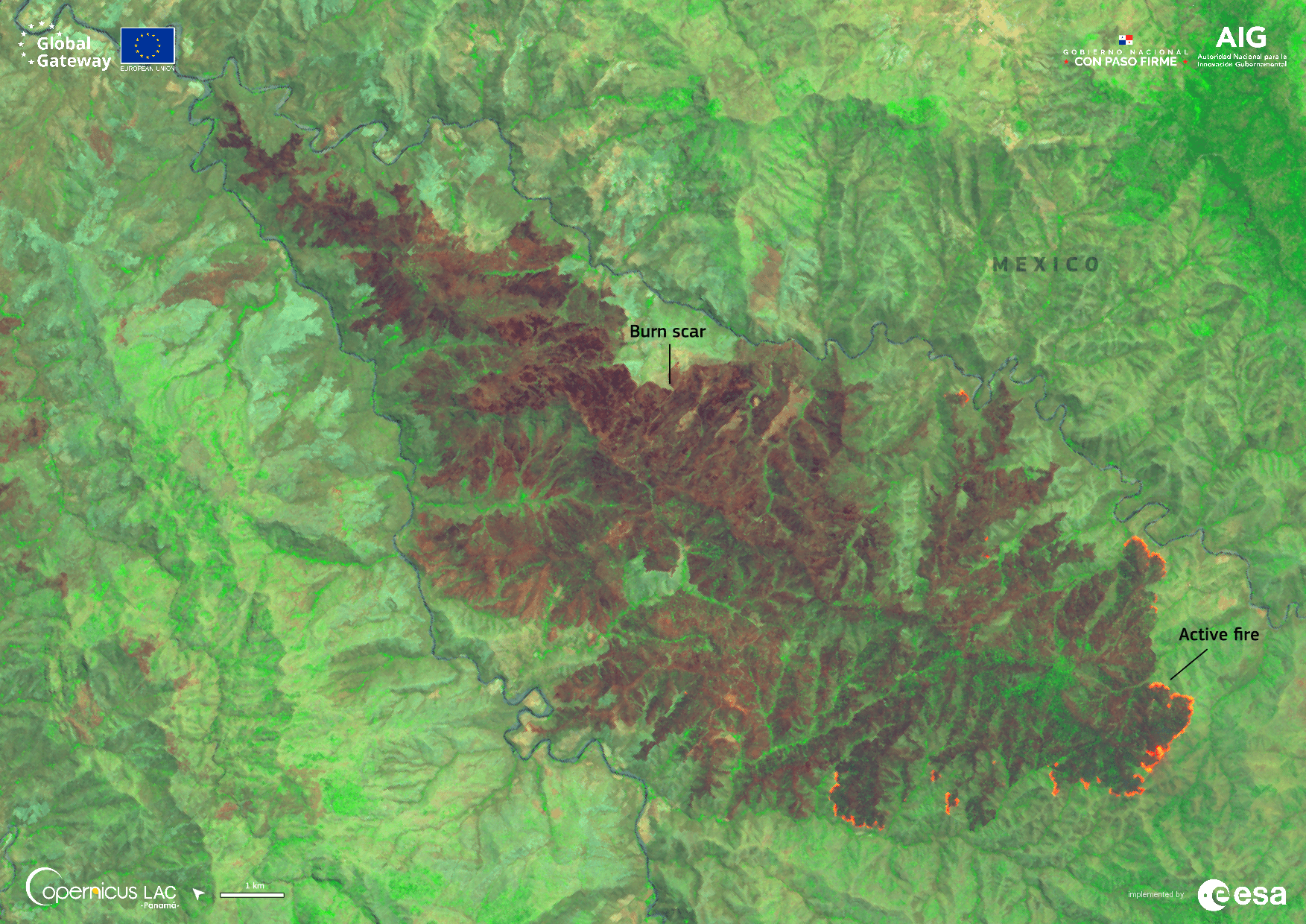
This false colour image acquired by one of the Copernicus Sentinel-2 satellites on 23 April 2025 shows the resulting burn scar from wildfires south of Ciudad Altamirano in the Mexican state of Guerrero. Credit: European Union, Copernicus Sentinel-2 imagery, processed by the CopernicusLAC Panama Centre
Spring marked the onset of widespread environmental devastation as wildfires swept across Mexico. A Copernicus Sentinel-2 image acquired on 23 April 2025 revealed extensive burn scars south of Ciudad Altamirano in Guerrero State, illustrating the rapid escalation of fire activity early in the year. By the end of 2025, a total of 8,106 wildfires were recorded across Mexico, burning approximately 27,955 km², an area equivalent to around 13 times the urban surface area of Mexico City. According to the Global Wildfire Information System (GWIS), this figure represents a reduction of approximately 20% relative to 2024 and 39% compared to 2023, indicating a notable downward trend in wildfire incidence over the past two years.
The CopernicusLAC Panama Centre’s EO services provide significant benefits in wildfire management across the LAC region. Within its Wildfire Theme, the Centre has co-developed tailored products which leverage Copernicus Sentinel data to enable timely and accurate wildfire assessment. An example of this is the Burned Area Mapping Service, which helps users understand and quantify wildfire-related damage by combining Sentinel-3 thermal anomaly detection with high-resolution Sentinel-2 imagery to map fire hotspots and burned-area extent, probability, and severity.
To further understand how EO data can be used for forest fire management, the centre’s free online course provides a range of lessons presented by EO professionals. These resources help LAC authorities and communities respond more effectively to wildfire emergencies, increase resilience, and guide recovery initiatives throughout the region.
Snow in the Atacama Desert
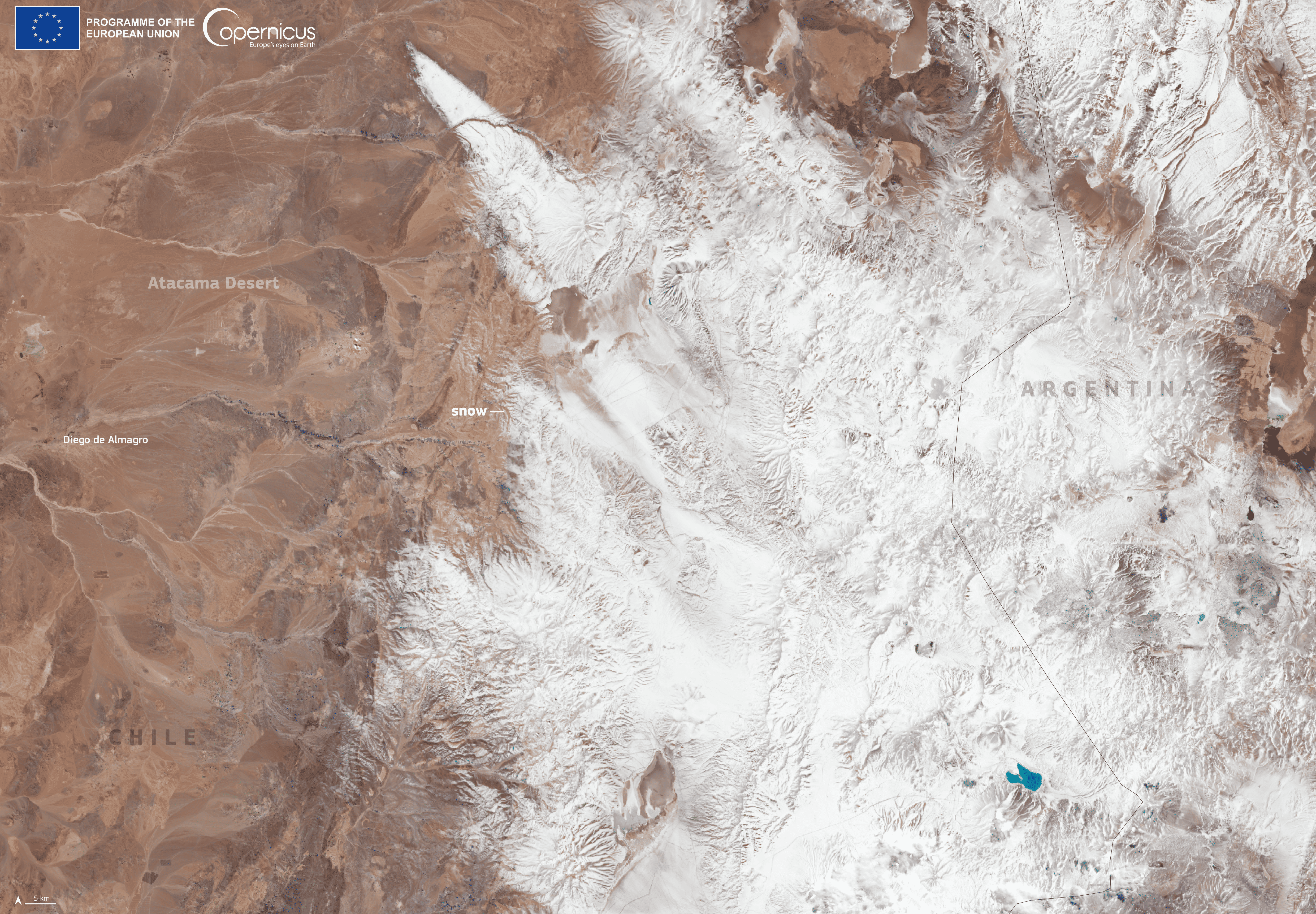
This Copernicus Sentinel-2 image, acquired on 26 June 2025, shows snow in part of the Atacama Desert in Chile and across the border in Argentina. Credit: European Union, Copernicus Sentinel-2 imagery.
A notable event in 2025 took place in Chile’s Atacama Desert, the driest place on Earth. On 26 June, rare snowfall blanketed the region, covering the Operations Support Centre of the ALMA Observatory in Chile, situated at an altitude of 2,900 metres. One of the Copernicus Sentinel-2 satellites acquired an image of significant snowfall covering the arid landscape.
This snow event was driven by an unusual cold-core cyclone (a “cutoff low”) which moved into the subtropics, puncturing the desert’s usual dry conditions and bringing precipitation to the high‑elevation Altiplano, a phenomenon which typically happens only occasionally and had not been seen there for more than a decade.
Floods in Southern Brazil
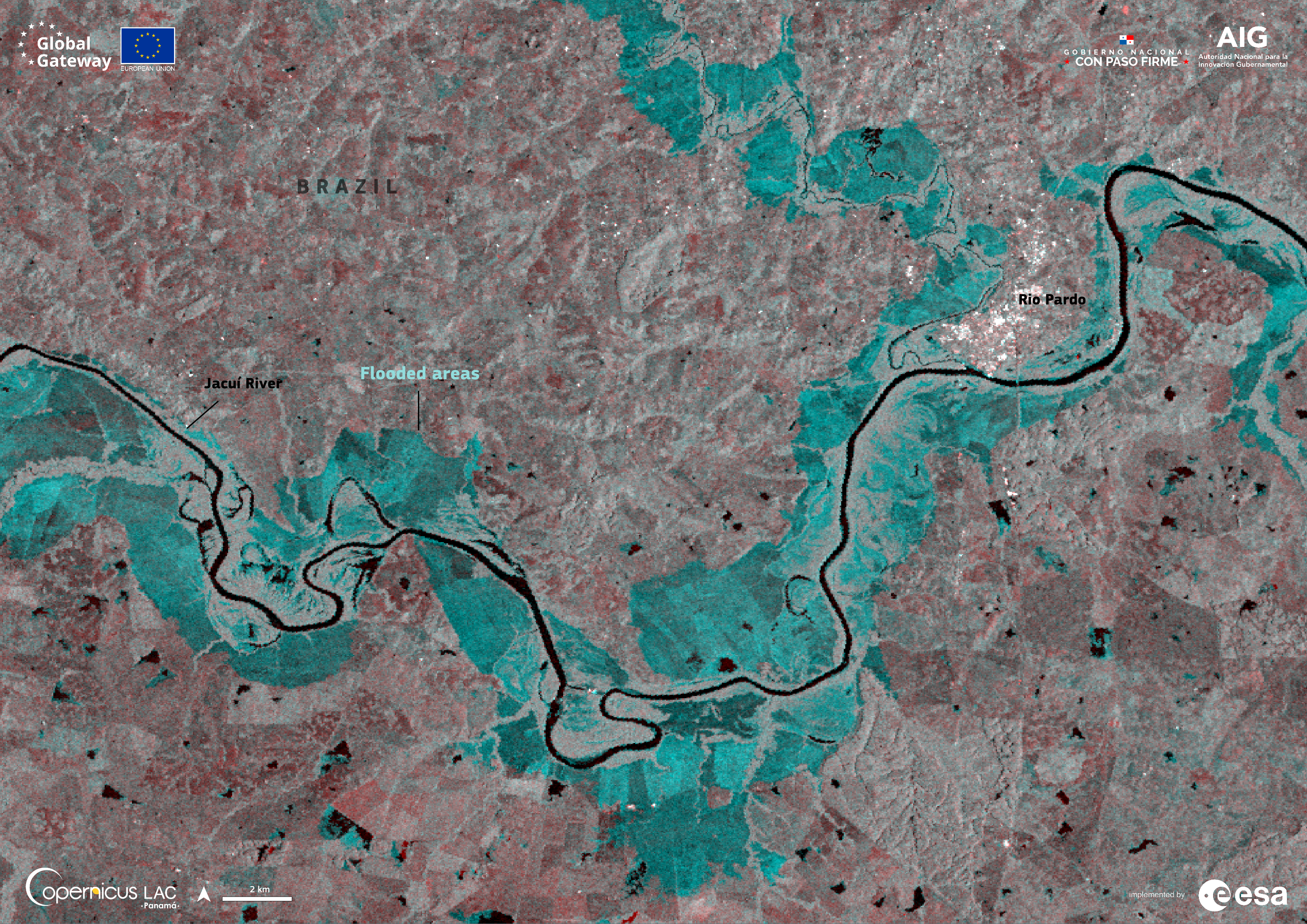
This Copernicus Sentinel-1 image acquired on 23 June 2025 shows flooded areas along the Jacuí River in southern Brazil. Credit: European Union, Copernicus Sentinel-1 imagery, processed by the CopernicusLAC Panama Centre
Heavy rains in mid‑June 2025 unleashed widespread flooding and landslides across southern Brazil’s Rio Grande do Sul, overwhelming rivers and forcing entire communities to evacuate. By 24 June, more than 7,000 people had been displaced, but lessons from recent major floods in Rio Grande do Sul appear to have strengthened preparedness and response during the June 2025 floods. In Cachoeira do Sul, the Jacuí River rose to 28 metres, well above its average level of 18 metres. The image acquired by a Sentinel-1 satellite on 23 June 2025 highlights the extent of the flooding around the Jacuí River.
The CopernicusLAC Panama Centre’s Hydrometeorological Hazards Theme EO Services support flood assessment and preparedness using Copernicus Sentinel data, with flood-mapping services tailored to regional needs. Notably, the Flood Extent Mapping Service generates flood delineation products for individual flooding events, producing maps which capture the maximum flood extent by integrating imagery from Copernicus Sentinel-1 and Sentinel-2 satellites. To deepen understanding of how EO data can aid flood risk assessment, the centre provides a free online course on Remote Sensing for Flood Monitoring, delivered by experienced EO specialists.
Hurricane Melissa’s Devastating Path
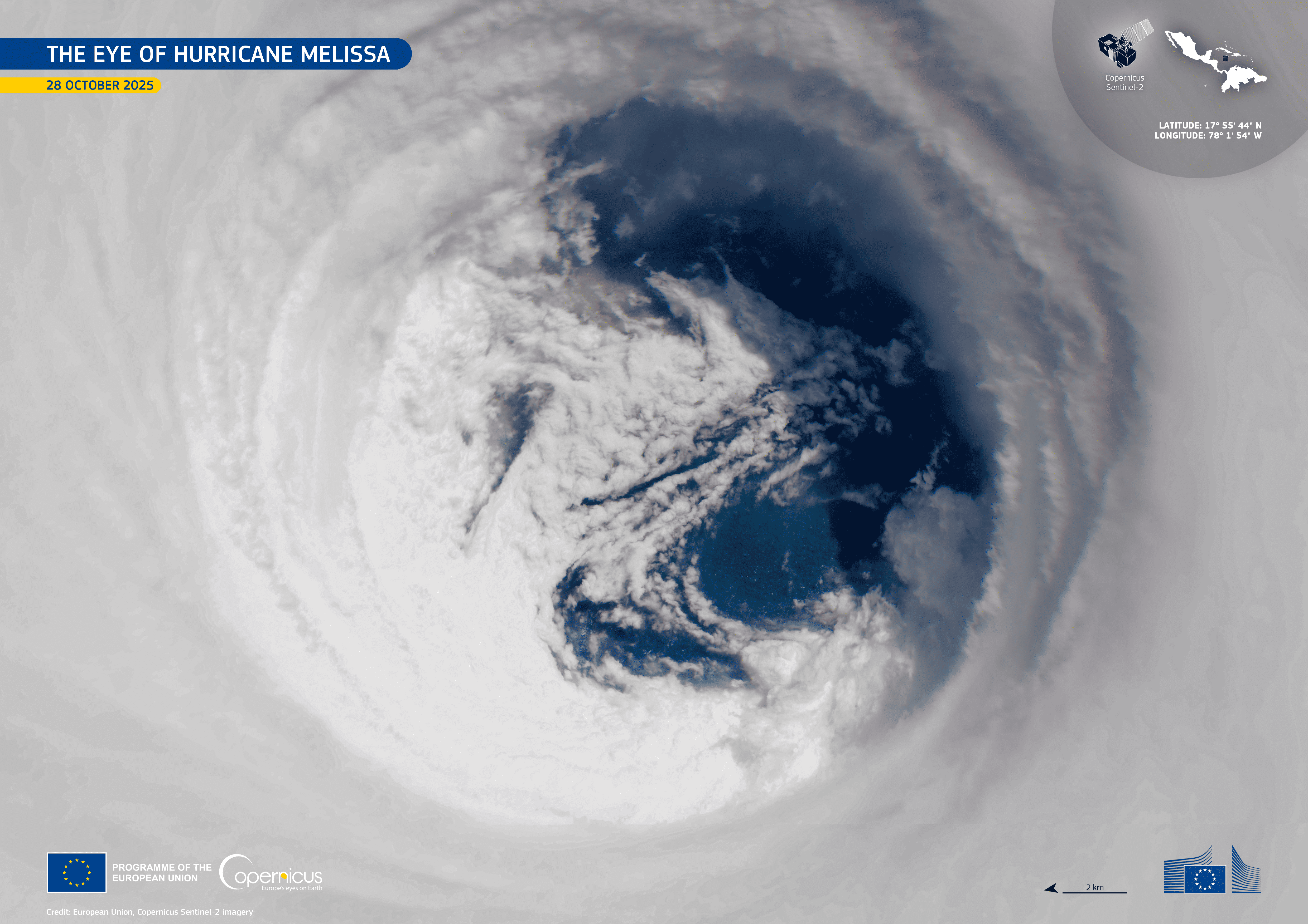
This image shows a vivid view of hurricane Melissa’s eye just a few hours before it made landfall on the southern coast of Jamaica. Credit: European Union, Copernicus Sentinel-2 imagery.
October marked one of the year’s most destructive events, as Hurricane Melissa rapidly intensified into a Category 5 storm before making landfall in Jamaica on 28 October. With sustained winds reaching 298 km/h and a central pressure of 892 hPa, Melissa ranked among the most intense hurricanes ever observed in the Atlantic. A report by Imperial College London, found that a “Melissa” type hurricane at landfall is about four times more likely in the 2025 climate compared to a pre-industrial baseline.
Just hours before landfall, Copernicus Sentinel-2 captured a striking image of the storm’s well-defined eye, highlighting the scale and intensity of the system. The impacts were catastrophic: damage in Jamaica alone exceeded US$8.8 billion, equivalent to approximately 41% of the country’s 2024 GDP. In response, the Copernicus Emergency Management Service was activated to support crisis response, producing rapid mapping of flood extents and damage across 39 areas of interest to support emergency response and recovery efforts.
Following Hurricane Melissa, the CopernicusLAC Panama Centre’s Exposure Theme EO Services were used for exposure mapping of economic assets, thereby supporting disaster management authorities and informing post-event relief and recovery actions. Within the CopernicusLAC Panama Centre’s Exposure Theme, the Economic Value Mapping Service is being developed to estimate the financial value of assets within a region by generating a detailed land-use and land-cover map. To deepen understanding of how EO data can be used for disaster risk management, the centre provides a free online course on Remote Sensing for Disaster Risks, featuring several recorded online sessions and related resources.
Conclusion: The Value of Earth Observation
The events of 2025 highlight the dynamic and changing nature of our planet. Each image acquired by Copernicus Sentinel satellite missions provides more than a compelling visual; it serves as a key tool for understanding environmental change and informing adaptive strategies.
By co-developing specialised EO Services for disaster management and climate monitoring, and by providing free and open access to extensive resources via its Digital Campus, the CopernicusLAC Panama Centre empowers decision-makers with the knowledge and tools to make informed, timely decisions and to build a resilient and sustainable future for the region leveraging Copernicus EO data.
Background Information
The activities of the CopernicusLAC Panama Centre fall within the overall context of the EU-LAC Digital Alliance, which is a strategic framework to promote cooperation between the European Union (EU) and the Latin America and Caribbean (LAC) region on digital and space issues under the umbrella of the EU Global Gateway strategy. In this context, the European Space Agency (ESA) coordinates the implementation of the Centre on the basis of a Contribution Agreement with the Directorate General for International Partnerships (DG INTPA) of the European Commission, and in close collaboration with the Government of Panama, the MIRE (Ministry of Foreign Affairs) and the SENACYT (National Secretariat for Science, Technology and Innovation).