





Latin America and the Caribbean experienced one of the most extreme years on record in 2025, with unprecedented heat, persistent droughts, torrential rain and devastating cyclones. Over the past five decades, rainfall in the region has become more extreme, with heavy precipitation increasing in Central America and northern South America, particularly in Colombia, Venezuela and the Amazon belt. Hurricane Melissa was the most dramatic example: in October 2025, it became the first Category 5 hurricane to make landfall in Jamaica. In 2026, intense rainfall continued to cause flooding, such as in Milagro, Ecuador, in February, and a possible El Niño event is expected in 2026–2027, which typically brings extreme rainfall and flooding to the southern Pacific coast.
Against this backdrop, floods have become one of the greatest threats facing the region, with serious socioeconomic and environmental consequences. To address them, the CopernicusLAC Panama Centre has developed Earth Observation services that make it possible to monitor the land surface and analyse these events. They combine imagery from the Sentinel-1 and Sentinel-2 satellites and have been demonstrated at operational level in two complementary use cases: flood preparedness in the Caribbean, and the analysis of flood frequency and impact in La Mojana, Colombia.
Flood preparedness in the Caribbean
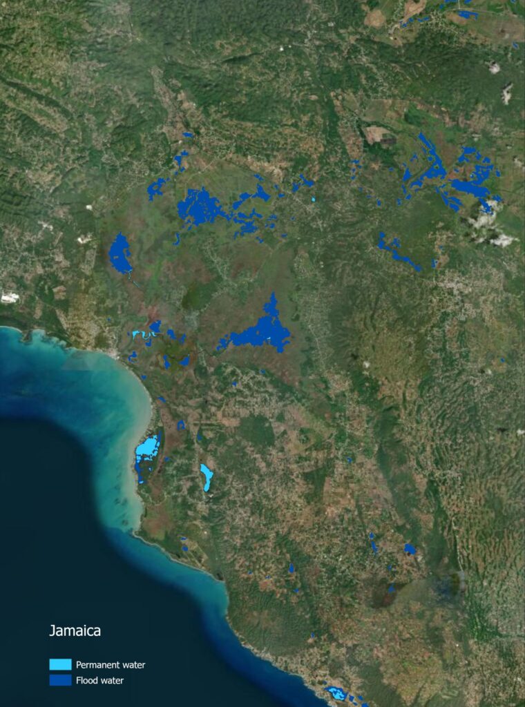
The first use case was designed to strengthen preparedness in Jamaica, Belize and Guyana. Two services were developed to capture the essential characteristics of a flood:
- Flood Extent Mapping (FEM): delineates flooded areas from the date of the event within a specified area of interest.
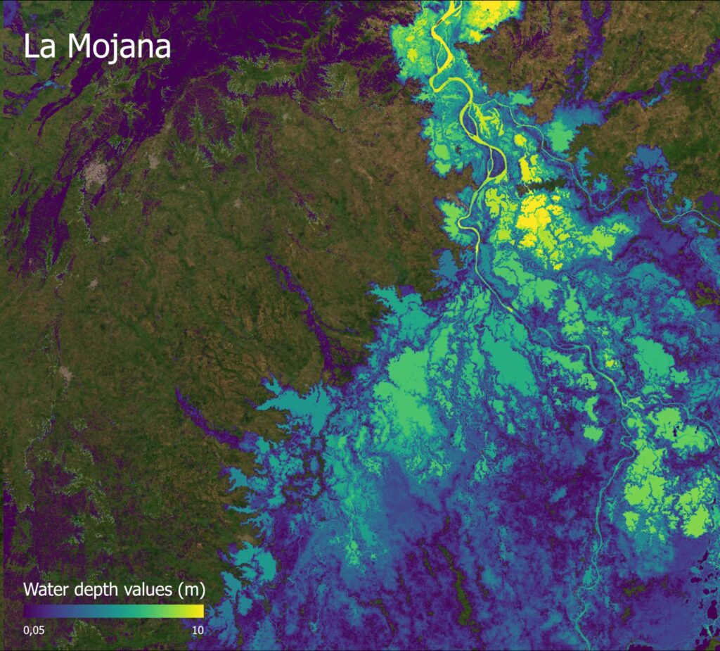
- Flood Depth Mapping (FlDM): estimates floodwater depth in a region of interest over a given time window.
Regional co-development
The work was carried out in close collaboration with regional bodies, such as the Caribbean Institute for Meteorology and Hydrology (CIMH) and the Caribbean Disaster Emergency Management Agency (CDEMA), and with national institutions in each country:
- Jamaica: Meteorological Service of Jamaica, Water Resources Authority (WRA) and Office of Disaster Preparedness and Emergency Management (ODPEM).
- Guyana: Hydro-Meteorological Service (HMS) and Civil Defence Department (CDC).
- Belize: National Meteorological Service (NMS), the Hydrology Department of the Ministry of Natural Resources, and the National Emergency Management Organisation (NEMO).
These institutions took an active part throughout the process, helping to identify areas of interest, select historical events, define the relevant hydrometeorological factors and validate the maps produced.
Belize: an operational reference archive
In Belize, an operational flood archive was created, bringing together extent and depth mapping linked to specific weather conditions. It serves as a reference tool for planning and for the preventive management of future flood events.
Jamaica: Hurricane Melissa as a real-world test
In Jamaica, the demonstration was carried out in response to Hurricane Melissa in October 2025. To track its impact, a dedicated workspace was set up on the CopernicusLAC Panama platform, where flood maps were updated regularly as new satellite images arrived. This monitoring proved crucial in identifying priority areas for intervention and in defining mitigation measures among the stakeholders managing the emergency.
Flood frequency and impact in La Mojana
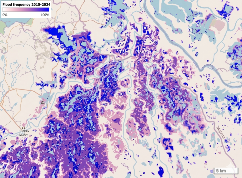
The second use case was developed in La Mojana, Colombia, one of the country’s regions most exposed to recurrent flooding. The Fondo Adaptación Nacional (FAN, the National Adaptation Fund) was the main user and technical partner, providing local data, validating products and helping to adapt the algorithms to national needs. The Instituto de Hidrología, Meteorología y Estudios Ambientales (IDEAM) and the Unidad Nacional para la Gestión del Riesgo de Desastres (UNGRD, the National Disaster Risk Management Unit) also took part, and their contributions steered the development towards applications of genuine operational value.
The main service is Flood Frequency Mapping (FFM), which automatically processes the entire historical archive of available Sentinel imagery and generates a frequency map that identifies the areas most susceptible to recurrent flooding and allows spatial patterns of hydrological behaviour to be analysed. Users can complement this information with the flood depth and impact services. Co-development with the Colombian institutions was decisive, as local data layers were incorporated and the algorithms were adjusted to users’ real needs, which strengthened the operational relevance of the services.
Results and lessons learned
The results of both use cases demonstrate the potential of the Earth Observation services developed by the CopernicusLAC Panama Centre. Thanks to users’ involvement at every stage of the project, the services were adapted to their needs and became effective tools for supporting decision-making. The cases offer invaluable lessons:
- Caribbean: an innovative approach was validated, based on reconstructing historical events and identifying analogous events to improve emergency preparedness.
- Jamaica: the experience with Hurricane Melissa showed the usefulness of the products during a real emergency.
- Colombia: automating flood frequency mapping established a permanent capacity for monitoring and analysing risk.
- La Mojana: the frequency analysis was implemented with a focus on planning and risk reduction.
These results confirm that Earth Observation can contribute effectively to flood risk management in Latin America and the Caribbean, above all when services are designed alongside the institutions that need them.