





The Peruvian Andes have a geography as imposing as it is dynamic. This mountain range is characterised by the frequent occurrence of landslides, processes that tend to intensify during the rainy season and, above all, in the presence of extraordinary climatic events such as the El Niño phenomenon. Steep slopes, geological diversity, and the presence of poorly consolidated soils create the ideal scenario for these processes, whilst earthquakes and certain human activities act as triggering factors.
This situation presents considerable challenges for risk management. According to national mapping produced by the Geological, Mining and Metallurgical Institute (INGEMMET), there are extensive areas of high and very high susceptibility to mass movements in regions ranging from Cajamarca, La Libertad, and Áncash in the north, to Arequipa, Moquegua, and Tacna in the south. In fact, the risk scenario of the National Centre for Disaster Risk Estimation, Prevention and Reduction (CENEPRED) for the 2025-2026 rainy season identifies 1,485 critical zones where these processes threaten populations and infrastructure.
The annual impact is highly variable and devastating; human lives are lost, ecosystems, housing, and roads are affected, and economic activities and the connectivity of exposed populations are disrupted.
Anticipate to protect
In light of this, the integration of satellite remote sensing and artificial intelligence opens a new path for understanding and managing risk. Through the service co-developed with the CopernicusLAC Panama Centre, as part of the use case on landslide susceptibility and hazard mapping, the Geophysics Institute of Peru (IGP) has substantially strengthened its analytical capacity, facilitating the transition towards a more proactive and preventative approach.
Previously, the production of a single regional susceptibility map required between 3 and 4 days of intensive processing. A large part of this time was spent downloading, preparing, and integrating satellite images with terrain variables, further constrained by the limitations of local computing infrastructure. With the automated platform of the CopernicusLAC Panama Centre, the time needed to generate a preliminary susceptibility map has been reduced to just 30 minutes.
This operational acceleration allows scientific teams to analyse multiple zones in record time, have objective prior information at their disposal, and optimise the planning of fieldwork before deployment on the ground.
Co-developed services to understand the terrain
The co-developed service integrates open, free, and high-quality data from the European Union’s Sentinel-2 satellites with advanced Artificial Intelligence algorithms, processed in an automated cloud-hosted chain.
Unlike traditional methodologies, such as the Analytic Hierarchy Process (Saaty), in which specialists manually and subjectively assign weights to terrain factors, the platform’s Artificial Intelligence models identify the relationships between variables and landslides directly from the available data. This makes it possible to consider complex terrain patterns, reduce subjectivity in weightings, and apply a standardised and uniform procedure.
“Before, it took us up to four days to prepare the images, integrate variables, and run the models. With the CopernicusLAC Panama platform, we generate a preliminary susceptibility map in just 30 minutes. This acceleration allows us to analyse multiple areas in record time and optimise our teams’ planning before going into the field.”— Wendy Quiroz, Researcher / Specialist at the Geophysics Institute of Peru (IGP)
For an institution like the IGP, the traceability of processes and the possibility of incorporating objective evaluation metrics are essential to validate the predictive performance of the model against the geological conditions observed in the field.
The case of the Colca Valley
One of the greatest contributions of this service has been its direct application in the Colca Valley, in Arequipa, where the generated maps were used as preliminary information to plan fieldwork and contrast the model’s results with the conditions observed directly on the ground.
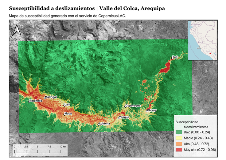
In this area, a large amount of critical infrastructure coexists, such as roads, local paths, and populated centres like Maca, Lari, Madrigal, Chivay, Yanque, and Coporaque. In addition, it is home to extensive areas of agricultural terraces, irrigation canals, and tourist infrastructure (viewpoints, thermal baths, and archaeological sites). Once validated, these maps become the input for prioritising the sectors that require detailed studies and preventative measures. The methodological success in Arequipa has paved the way for its upcoming use in regions such as Huancabamba, in Piura.
The importance of institutional anticipation
When considering decisionmakers, Civil Defence, and the teams responsible for disaster risk management, the impact of Earth Observation services changes the paradigm of action.
Although these products do not allow for the exact prediction of when a landslide will occur, nor do they replace in situ monitoring, their true value lies in anticipation. Institutions no longer need to wait for an emergency to occur to begin data collection and analysis.
With susceptibility maps, authorities can identify beforehand the zones with the most favourable conditions for events to occur, plan inspections, focus attention on vulnerable infrastructure, and draw up specific protocols. Ultimately, tools such as those provided by the CopernicusLAC Panama Centre are allowing Peru to make better use of its resources and transition towards a much more anticipatory, proactive, and focused risk management.
The CopernicusLAC Panama Centre and its contribution to disaster risk reduction in Latin America and the Caribbean
The experience in the Peruvian Andes illustrates how the services of the CopernicusLAC Panama Centre (framed within the EU’s Global Gateway strategy) reduce disaster risk in Latin America and the Caribbean. Faced with high exposure to mass movements, anticipating these threats is a strategic advantage.
Its Earth Observation services strengthen three important aspects of geological risk management:
- Territorial awareness
- Preventative action
- Sustainable planning
In this way, the CopernicusLAC Panama Centre goes beyond providing cloud technology, as it drives a definitive transition from simple emergency reaction towards a culture of proactive, data-driven anticipation.
Background information
The activities of the CopernicusLAC Panama Regional Centre are developed in the framework of the EU-LAC Digital Alliance, which is a strategic framework to promote cooperation between the European Union (EU) and the Latin America and Caribbean (LAC) region on digital and space issues under the umbrella of the EU Global Gateway strategy. In this context, the European Space Agency coordinates the implementation of the Centre on the basis of a Contribution Agreement with the Directorate General for International Partnerships (DG INTPA) of the European Commission, and in close collaboration with the Government of Panama, the Ministry of Foreign Affairs (MIRE), the Government Innovation Agency (AIG), and the SENACYT (National Secretariat for Science, Technology and Innovation).