


Latin American and Caribbean (LAC) countries are some of the world’s most vulnerable when it comes to climate-related hazards and the consequences of El Niño and La Niña. These phenomena impact the region’s unique ecosystems, including tropical rainforests, coastal areas, and mountainous terrain and lead to effects such as rising temperatures, extreme weather events and droughts, and changing precipitation patterns. These same consequences affect the livelihoods of citizens of LAC countries, many of whom depend on sectors which are particularly vulnerable to the effects of climate change.
In this context, the CopernicusLAC Panama Centre is ramping up its operations, poised to support the use of Copernicus’ free and open Earth Observation (EO) data across Latin America and the Caribbean. Serving as a regional hub, the Centre will help LAC countries leverage Copernicus data for Disaster Risk Reduction (DRR) and other areas of application, while contributing to increasing regional resilience to climate change. The Centre’s activities take place alongside those of the CopernicusLAC Data Centre in Chile. The complementary activities of the two Centres will allow them to bring Copernicus open data closer to the LAC region.
Empowering Latin America and the Caribbean through Copernicus EO Data
The Copernicus LAC Panama Centre’s activities take place within the overall context of the EU-LAC Digital Alliance, which is a strategic framework for promoting cooperation between the EU and the LAC region on digital and space issues under the EU Global Gateway umbrella. Within this context, the European Space Agency (ESA) is coordinating the Centre’s implementation on the basis of a Contribution Agreement with the Directorate-General for International Partnerships (DG INTPA) of the European Commission, and in close collaboration with Panama’s government, MIRE (Ministry of Foreign Affairs), Government Innovation Authority (AIG), and SENACYT (National Secretariat for Science, Technology and Innovation).
The Centre will serve as a platform for innovation in the LAC region by supporting local entities in leveraging Copernicus EO data and information for improved socio-economic benefits and resilience. The Centre provides engagement opportunities and is designing tailored geospatial pilot services (addressing hydrometeorological hazards, geological hazards, and exposure services), which are developed in close collaboration with, and will be handed over to local users and stakeholders to ensure that the unique needs of the region are addressed over the long term. Furthermore, knowledge and skills transfer are a key element of the CopernicusLAC Panama Centre, which hosts a Digital Campus with access to training modules and educational resources for technical users and citizens alike. The Centre will also organise political dialogues, community-building and industrial matchmaking events, as well as hackathons and other EO data challenges to foster user uptake and innovation using Copernicus data. Likewise, these events will foster the collaboration and cross-fertilisation of the EO, DRR, and other relevant ecosystems. Finally, the Centre will include the development of a high power and cloud computing infrastructure for the LAC region. One of the ultimate goals of the Centre is also to promote the development of communities of practice and strengthen capabilities in the public sector, academia, the private sector and within social organisations in the knowledge about and use of tools for DRR and other areas.
Copernicus: Taking the Pulse of Our Planet
Copernicus provides a wealth of data and information which are free and openly accessible to all. A great strength of Copernicus lies in its complementary components: the Copernicus Sentinel satellites and the Copernicus Services. The family of Sentinel satellites, designed specifically for the programme, is constantly orbiting our planet, gathering invaluable data on the Earth’s environment and human activities. In addition, observations are obtained from various Contributing Missions, which belong to European and international organisations which supply some of their data to Copernicus. Copernicus information is also often based on a fusion with data from ground-based, airborne or marine sensors, providing decision-makers, researchers, and the general public with a comprehensive view on several phenomena and environmental parameters.
In addition to its free and open satellite data, a great strength of Copernicus lies in its six Services, each dedicated to transforming EO and in situ data into value-added information.
Copernicus Atmosphere Monitoring Service (CAMS)
CAMS provides key information on air quality, ozone levels, solar radiation, and greenhouse gases, delivering important data to policymakers, businesses, and citizens alike. This information supports the understanding and mitigation of the impacts of air pollution and Climate Change on people’s health and the environment, while also supporting the development of the renewable energy sector.
CAMS data has numerous applications in the LAC region. One CAMS product, which forecasts of the distribution of atmospheric aerosols, serves as a prime example. Atmospheric aerosols are small particles or liquid droplets suspended in the atmosphere and which can originate from wildfires, volcanic eruptions, desert dust, or human activity. Forecasts of their distribution can have important applications for public health by providing data on the total amount of aerosol in the atmosphere, as well as the individual levels of sea salt, desert dust, black carbon, and more. This information can empower local communities and decisionmakers in their actions to limit local populations’ exposure to harmful aerosols.
The same data can also benefit researchers studying the local impacts of Climate Change. Since aerosols influence the climate by affecting cloud formation and reflecting or absorbing sunlight, this information allows authorities and researchers to better understand and forecast Climate Change patterns.
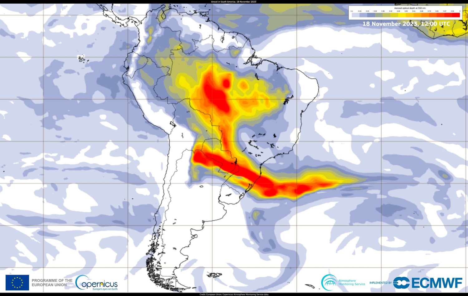
Distribution of aerosols in South America on 18 November 2023 modelled by CAMS. Credit: European Union, Copernicus Atmosphere Monitoring Service (CAMS)
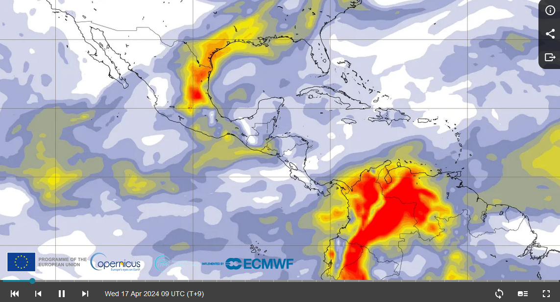
Distribution of aerosols in Central America on 20 April 2024 modelled by CAMS. Credit: European Union, Copernicus Atmosphere Monitoring Service (CAMS)
Copernicus Marine Service (CMEMS)
The world’s oceans are vital to our planet’s well-being. CMEMS delivers essential information on ocean conditions, supporting efforts to combat pollution, protect marine ecosystems, and ensure maritime safety. Information from CMEMS helps scientists, innovators, and authorities understand how Climate Change and human activities are impacting the health of our oceans.
One product provided by CMEMS is data on seawater salinity. Monitoring seawater salinity is key for a number of sectors: for marine ecosystem management, it helps manage fisheries and monitor marine species distribution and survival rates. Seawater salinity data supports researchers in understanding interactions between rivers, groundwater, and the ocean, since salinity levels affect the mixing of freshwater and seawater in estuaries and coastal regions. This data also has applications in climate research, since changes in water salinity can affect ocean circulation patterns, and thus global climate systems.
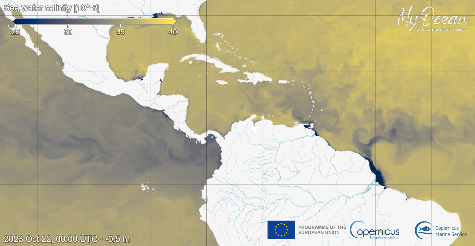
Seawater salinity in Central America on 22 October 2023 modelled by CMEMS. Credit: European Union, Copernicus Marine Service (CMEMS)
Copernicus Land Monitoring Service (CLMS)
Since landscapes are constantly evolving, CLMS has been established to provide detailed geospatial information on land cover, land use, and biophysical parameters. This data is useful for urban planning, agriculture, and forest management, helping to balance development with environmental conservation.
CLMS provides one of the world’s most robust portfolios of open-access land cover and land use datasets. In the LAC region, this data has a wide range of uses, including tracking the status of the rainforests, forest degradation, and reforestation efforts. This information can be used for studies of biodiversity, assessments of vegetation stress, and estimates for forest fire season preparedness. Ultimately, CLMS data provides valuable insights for conservation strategies and improved policymaking, and deforestation monitoring, ensuring a more sustainable future for land in the LAC region.
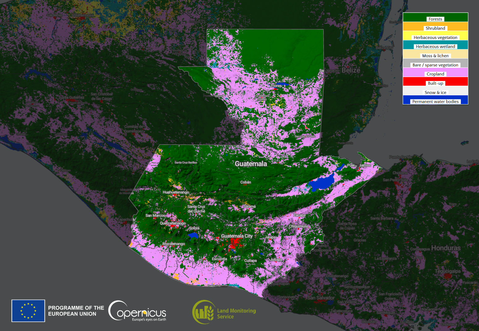
Land use map of Guatemala modelled by CLMS. Credit: European Union, Copernicus Land Monitoring Service (CLMS)
Copernicus Climate Change Service (C3S)
In the face of Climate Change, C3S is an important resource, providing reliable data on climate trends and their impact on selected sectors of the economy. Among other things, this service supports sustainable water management and biodiversity assessments, helping societies around the world adapt to a changing climate.
In the LAC region, C3S datasets can serve as a key resource for accurate data on local and regional impacts of Climate Change. C3S provides datasets on Surface Air Temperature anomalies, which can be used to track global warming trends. Temperature anomalies can also help evaluate the impact of droughts, plan for sustainable water use, and inform economic assessments of the impacts of temperature variations on various sectors.
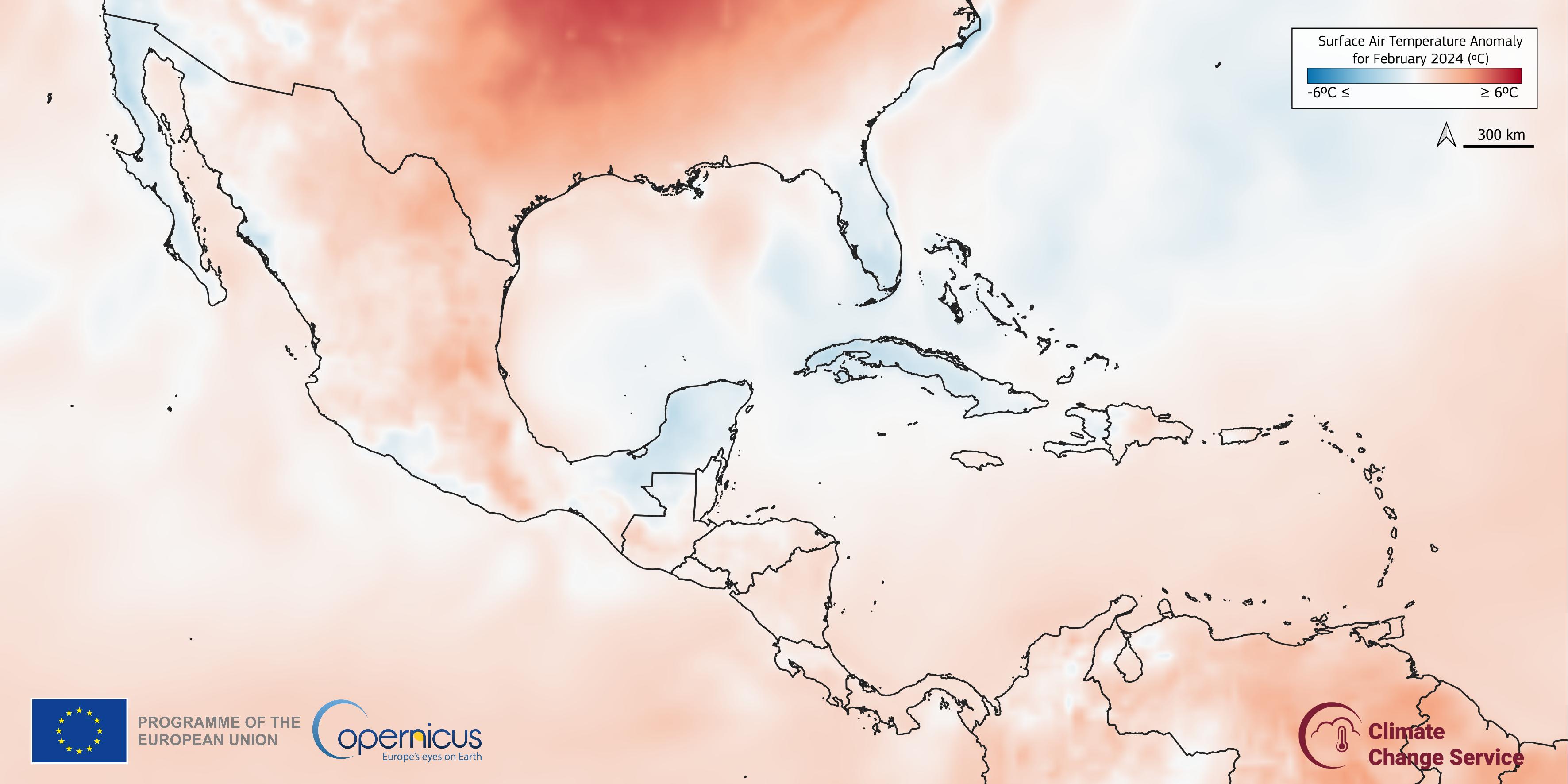
Surface Air Temperature Anomalies in Central America for February 2024 modelled by C3S. Credit: European Union, Copernicus Climate Change Service (C3S)
Copernicus Emergency Management Service (CEMS)
Before and when disasters strike, timely and accurate early warnings and information can save lives. CEMS provides key geospatial information for disaster risk reduction and emergency management, from early warnings for floods, wildfires and droughts, to detailed on-demand mapping products covering all the phases of the disaster management cycle. This data improves community efforts in preventing, responding to, and recovering from emergencies around the world.
Floods are the most common type of disaster in the LAC region, and as the climate continues to change, the frequency and severity of floods will increase. In this regard, CEMS provides flood forecasts and monitoring products as well On-Demand Mapping services which allow authorities to identify the extent of flooded areas and to respond accordingly, leading to better community outcomes after a disastrous event.
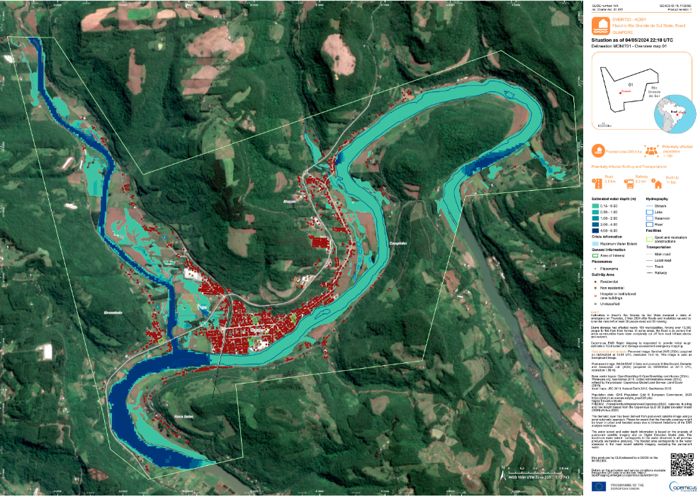
Floods Delineation Monitoring product for the area of Guaporé, Brazil, derived from a satellite image acquired on 4 May 2024 (EMSR720). Credit: European Union, Copernicus Emergency Management Service (CEMS)
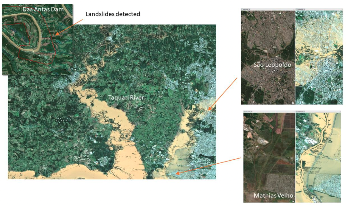
Copernicus Sentinel-2 image acquired on 6 May 2024 showing landslides, flooded areas, and damage to buildings and infrastructure in Brazil (EMSR 720). Credit: European Union, Copernicus Emergency Management Service (CEMS)
Copernicus Security Service (CSS)
Security in a complex world requires reliable and timely information. CSS data supports European Union authorities in anticipating and addressing crises and conflicts, with applications in climate security, international trade, and citizen safety. Among other areas, CSS data informs border and maritime surveillance.
Looking Ahead
The CopernicusLAC Panama Centre will usher in a new era of resilience and sustainability for Latin America and the Caribbean. By harnessing the power of Copernicus EO data and information, the region will be better equipped to face the challenges such as Climate Change-induced extreme weather events, and geohazards, safeguarding its rich landscapes, unique biodiversity and vibrant cultures for future generations.