


Date: 30 April 2024
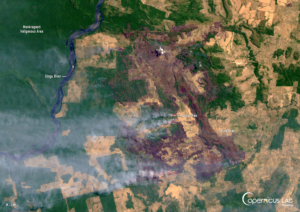
Location: Menkragnoti Indigenous Area, Brazil
Credit: Copernicus Sentinel-2 image, processed by the CopernicusLAC Panama Centre
Description:
According to the United Nations Office for the Coordination of Humanitarian Affairs, 30.8 million hectares of land in Brazil were burnt by wildfires in 2024. This number, larger than the total area of Italy, is a 79% increase from 2023. Experts suggest that the fires in Brazil in 2024 were intensified by both the El Niño phenomenon and the most severe drought to affect the country since 1950.
In this Copernicus Sentinel-2 image, acquired on 30 April 2024, an active fire and a burn scar are visible in the Menkragnoti Indigenous Area in the state of Para in north-central Brazil.
Open data from the Copernicus Sentinel satellites serves as an essential resource for tracking the extent of wildfires and assessing their consequences on ecosystems and communities across the Latin American and Caribbean (LAC) region. Read more about the applications of Copernicus data for wildfires in this blog article.
In this context, the CopernicusLAC Panama Centre works to bring Copernicus data closer to users in the LAC region by providing trainings and educational resources on Copernicus data for wildfires. The series of training courses includes a module on “Remote sensing in preparation for forest fires”, the materials of which will be made available to all registered users of the CopernicusLAC Panama Centre Digital Campus.
The Centre is further developing three streams of Earth Observation (EO)-based pilot services to be handed over to local stakeholders for continued implementation after the end of the pilot demonstration phase. One of these streams – the hydrometeorological service – includes a pilot service dedicated to wildfires. It is composed of three open-source tools designed to help address wildfires before, during, and after they take place. It will increase the ability of institutions in the LAC region to respond to challenges resulting from wildfires more effectively. More information about the wildfire pilot service is available here.
To stay updated on upcoming trainings and additions of modules to the Digital Campus, be sure to follow our Centre on LinkedIn, Instagram, X, and subscribe to our newsletter.
Background Information
The Copernicus LAC Panama Centre’s activities take place within the overall context of the EU-LAC Digital Alliance, which is a strategic framework for promoting cooperation between the EU and the LAC region on digital and space issues under the EU Global Gateway umbrella. Within this context, the European Space Agency (ESA) is coordinating the Centre’s implementation on the basis of a Contribution Agreement with the Directorate-General for International Partnerships (DG INTPA) of the European Commission, and in close collaboration with Panama’s government, MIRE (Ministry of Foreign Affairs), Government Innovation Authority (AIG), and SENACYT (National Secretariat for Science, Technology and Innovation).
The CopernicusLAC Panama Centre will serve as a hub for innovation in the Latin America and Caribbean region, supporting national and local entities in leveraging Copernicus data and information to boost socio-economic benefits and resilience. In addition to providing engagement opportunities, the Centre is developing geospatial Disaster Risk Reduction (DRR) Pilot Services (addressing hydrometeorological hazards, geological hazards, and hazard exposure) in close collaboration with local users and stakeholders, to whom they will be handed over to ensure that the unique needs of the region are addressed in the long term.
In addition, knowledge and skills transfer is a key element of the CopernicusLAC Panama Centre, which hosts a Digital Campus with access to training modules and educational resources for technical users and citizens alike. The Centre will also organise community-building events, policy dialogues and industry matchmaking, as well as hackathons and other Earth Observation (EO) data challenges to stimulate user adoption of Copernicus data and innovation. These events will also foster cross-collaboration among EO, disaster risk reduction (DRR) and other relevant ecosystems.
Finally, the Centre will support the development of a high-power computing and data storage cloud infrastructure for the LAC region. One of the final objectives of the Centre is to promote the development of communities of practice and to strengthen the knowledge and use of tools for DRR and other application areas in the public sector, academia, the private sector, and social organisations.