



The Latin American and Caribbean (LAC) region is uniquely vulnerable to geological hazards as demonstrated by the recent events in Venezuela and Colombia. Copernicus satellite data offers unique information during the phases before and after disasters strike.
Following the devastating 7.4 magnitude earthquake that struck Colombia on August 10, the Copernicus Emergency Management Service (CEMS) was immediately activated (EMSR916). Teams from UNITAR-UNOSAT are currently utilizing critical satellite-derived products to map building damage and guide rescue efforts on the ground. The International Charter: Space and Major Disasters has also been activated, with institutions collaborating to provide information on the extent of the damage.
This immediate crisis response comes just two months after a major seismic event in Venezuela (EMSR884), highlighting an urgent need across the region for rapid, actionable Earth Observation (EO) data and analytic capabilities.
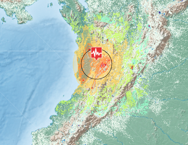
The ongoing response in Colombia mirrors the massive international mobilization seen during the Venezuela earthquake earlier this summer. During that emergency, operational cooperation between CEMS and the International Charter resulted in the rapid acquisition of critical satellite imagery. To leverage this data, regional space agencies, including ABAE (Venezuela), CONIDA (Peru), INPE (Brazil), and CONAE (Argentina), worked alongside international partners to generate 73 distinct value-added products, such as surface displacement and building damage maps.
While responding to emergencies is critical, the true goal of the CopernicusLAC Panama Centre is to empower LAC nations to transition from reactive crisis management to proactive, resilient disaster prevention. The Centre serves to ensure that this level of world-class satellite data, technical infrastructure, and analytical capacity is permanently and seamlessly accessible to LAC nations.
Building Capacity: Training for the Future
The ground cannot be stopped from shaking, but through the CopernicusLAC platform, regional authorities can access specialized data to prepare before disaster strikes. A prime example of this proactive approach is the capacity-building event held in Panama City this past April.
Representatives from Panama (including the Government Innovation Agency, the Institute of Geosciences of the University of Panama, and the Institute of Meteorology and Hydrology) and Ecuador participated in an intensive, two-day training focused on Synthetic Aperture Radar Interferometry (InSAR). Led by experts from the Aristotle University of Thessaloniki, the training taught local authorities how to process Copernicus Sentinel data using the GeoHazards Workspace to create detailed maps of ground movements. By analyzing subtle land deformations, users can identify high-risk areas for landslides, subsidence, and active tectonic shifts before a major rupture occurs.
Putting Training into Action: New Land Deformation Use Cases
Building directly upon this regional training, the CopernicusLAC Panama Centre is currently rolling out two new strategic use cases utilizing Sentinel-1 radar data and InSAR techniques to monitor land deformation on a massive scale.
These initiatives use three complementary analytical services, including KinesIS Ground Motion Mapping, Persistent Scatterer Interferometry (PSI), and 3D Geometric Decomposition, to translate complex geological data into actionable insights for end-users, covering long-term deformation patterns, slow displacement time series, and the separation of vertical and horizontal ground motion.
Use case 1. Mass Production in Central America: The first use case is a large-scale data collection and processing exercise currently being implemented across Guatemala, El Salvador, and Costa Rica. This involves deep collaboration with national seismic, meteorological, and disaster response agencies (e.g., National Institute of Seismology, Vulcanology, Meteorology and Hydrology and the National Coordinator for the Reduction of Disasters) alongside international bodies like DG-ECHO to ensure outputs meet local monitoring needs.
Use case 2. Medium-Scale Monitoring in Mexico and Panama: The second use case applies these same InSAR services to target regional areas in Mexico and Panama. This involves a coalition of Mexican institutions (ranging from the Geological Survey and Civil Protection to forestry and water commissions) as well as the Panama Canal Authority.
By integrating this highly accurate mapping directly into institutional systems, authorities can better identify risk zones and implement effective mitigation measures. Through continuous partnership under the EU-LAC Digital Alliance, CopernicusLAC Panama is enhancing the use and analytical capacity of Copernicus data in Latin American and Caribbean nations to build a safer, more resilient future.
Background information
The activities of the CopernicusLAC Panama Regional Centre are part of the EU-LAC Digital Alliance, which is a strategic framework to promote cooperation between the European Union (EU) and the Latin America and Caribbean (LAC) region on digital and space issues under the umbrella of the EU Global Gateway strategy. In this context, the European Space Agency (ESA) coordinates the implementation of the Centre on the basis of a Contribution Agreement with the Directorate General for International Partnerships (DG INTPA) of the European Commission, and in close collaboration with the Government of Panama, the Ministry of Foreign Affairs (MIRE), the Government Innovation Agency (AIG), and the SENACYT (National Secretariat for Science, Technology and Innovation).